
Teesta River facts for kids
Quick facts for kids Teesta River |
|
 |
|
| Countries | India, Bangladesh |
|---|---|
| States | Sikkim, West Bengal, Rangpur |
| City | Kalimpong, Jalpaiguri |
| Source | Pauhunri glacier |
| - location | Sikkim, India |
| - elevation | 7,068 m (23,189 ft) |
| Mouth | Brahmaputra river |
| - location | Fulchori, Rangpur, Bangladesh |
| Length | 309 km (192 mi) |
| Basin | 12,540 km² (4,842 sq mi) |
The Teesta River (also called Tista) is a very important river. It flows through the Indian states of Sikkim and West Bengal. Then, it enters Bangladesh. This river is about 309 kilometres (192 miles) long. It provides water for many people and helps with farming and electricity.
Where the Teesta River Flows
The Teesta River begins high up in the Sikkim Himalaya mountains. It starts from the Pauhunri glacier, which is a huge body of ice. From there, the river flows south. It rushes through rapids in the mountains.
The river passes by the town of Rangpo. As it continues south, it enters West Bengal. Finally, the Teesta River joins the mighty Brahmaputra River in Bangladesh.
Importance of the Teesta River
The Teesta River is very important for the areas it flows through. It helps farmers grow crops by providing water for irrigation. The river also has dams and barrages built on it. These structures help control the water flow. They also generate electricity for homes and businesses.
Many people also depend on the river for fishing. The Teesta River supports a variety of plants and animals. It is a vital part of the natural environment in this region.
Images for kids
-
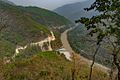
Teesta and Rangeet Confluence
-
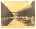
British Engineering - Teesta Suspension Bridge in Sikkim (1894)
-
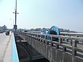
Teesta Barrage on the river Teesta, Bangladesh.
-
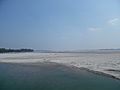
View of the Teesta river from Teesta Bridge of Bangladesh on March 2019. Downstream.

_p022_TEESTA_SUSPENSION_BRIDGE.jpg)
.jpg)
_(01.03.2019)_.jpg)
See also
 In Spanish: Río Tista para niños
