
Rangpur District facts for kids
Quick facts for kids
Rangpur
রংপুর
|
|
|---|---|

Location of Rangpur in Bangladesh
|
|
| Country | |
| Division | Rangpur Division |
| Area | |
| • Total | 2,400.56 km2 (926.86 sq mi) |
| Population
(2011 census)
|
|
| • Total | 2,996,336 |
| • Density | 1,248.1821/km2 (3,232.777/sq mi) |
| Demonym(s) | Rangpuri, Rongpuri |
| Time zone | UTC+06:00 (BST) |
| Postal code |
5400
|
Rangpur is an important district located in the northern part of Bangladesh. It is a key area within the larger Rangpur Division. This district was officially created in 1772, making it a place with a long history.
Contents
Exploring Rangpur's Geography
Rangpur District is part of the Rangpur Division, which is one of the eight main areas of Bangladesh. It's located in the northern part of the country.
Borders and Neighbors
Rangpur shares its edges with several other districts. To the north, you'll find Nilphamari District. To the south, it borders Gaibandha District. On its eastern side is Kurigram District, and to the west lies Dinajpur. The main city of Rangpur serves as the headquarters for the entire division.
Soil and Climate
The land in Rangpur is mostly made up of a special type of soil called alluvial soil. This rich soil, which makes up about 80% of the area, is carried and deposited by the Teesta River. The rest of the soil is known as barind soil.
The weather in Rangpur is generally warm. Temperatures usually range from 11 degrees Celsius (about 52 degrees Fahrenheit) to 32 degrees Celsius (about 90 degrees Fahrenheit). The district also gets a lot of rain, with an average of 2931 millimeters (about 115 inches) of rainfall each year.
Images for kids
-
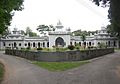
Zilla Porishod Building.
-
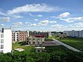
Campus of Begum Rokeya University
-
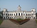
Tajhat Palace in Rangpur
-
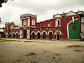
Rangpur town hall


See also
 Learn more about Rangpur in Spanish: Rangpur (zila) para niños
