Nilphamari District facts for kids
Quick facts for kids
Nilphamari
নীলফামারী
|
|
|---|---|

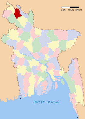
Location of Nilphamari in Bangladesh
|
|
| Country | |
| Division | Rangpur Division |
| Area | |
| • Total | 1,546.59 km2 (597.14 sq mi) |
| Population
(2011 census)
|
|
| • Total | 1,834,231 |
| • Density | 1,185.984/km2 (3,071.684/sq mi) |
| Literacy rate | |
| • Total | 25.35% |
| Time zone | UTC+6 (BST) |
| • Summer (DST) | UTC+7 (BDST) |
| Website | www.nilphamari.gov.bd |
Nilphamari (Bengali: নীলফামারী জেলা) is a district in the northern part of Bangladesh. It is a part of the Rangpur Division. Districts in Bangladesh are like counties or provinces in other countries. They help organize the government and services for people.
Contents
Understanding Nilphamari's Subdistricts
Nilphamari District is divided into several smaller areas called Upazilas. Think of these as smaller towns or administrative zones within the district. Each Upazila has its own local government. This helps manage things like schools, health services, and local development.
List of Upazilas and Their Populations
Here are the main Upazilas in Nilphamari District, along with how many people lived in them according to the 2011 census:
- Nilphamari Sadar (নীলফামারী সদর): This is the central Upazila. It had 306,051 people.
- Saidpur (সৈয়দপুর): This area had 246,201 people.
- Jaldhaka (জলঢাকা): About 233,885 people lived here.
- Kishoreganj (কিশোরগঞ্জ): This Upazila had 199,422 residents.
- Domar (ডোমার): Around 187,696 people lived in Domar.
- Dimla (ডিমলা): This area was home to 175,507 people.
These numbers show how many people live in each part of the district. They help local leaders plan for the needs of the community.
Geography and Location
Nilphamari is located in the northern region of Bangladesh. It is known for its flat plains and fertile land. The district is part of the larger Rangpur Division. This division is important for agriculture in Bangladesh.
Climate and Environment
The climate in Nilphamari is generally tropical. It has hot, humid summers and mild winters. The area receives a lot of rain during the monsoon season. This rainfall is very important for farming. The land is mostly rural, with many fields and small villages.
Economy and Daily Life
Most people in Nilphamari work in agriculture. They grow crops like rice, jute, and various vegetables. Fishing is also a common activity. The district's economy relies heavily on farming. Local markets are busy places where people buy and sell goods.
Education and Development
Nilphamari has various schools and colleges. These institutions help educate the young people of the district. The government and local organizations work to improve education and healthcare. They also focus on developing roads and other important services.
See also
 In Spanish: Nilphamari (zila) para niños
 | Laphonza Butler |
 | Daisy Bates |
 | Elizabeth Piper Ensley |

