Rangpo facts for kids
Quick facts for kids
Rangpo
|
|
|---|---|
|
Municipality
|
|

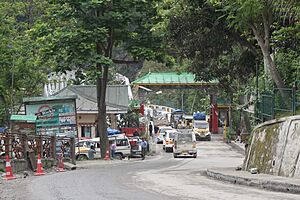
Rangpo Police Checkpoint, Sikkim
|
|
| Country | |
| State | |
| District | Pakyong District |
| Government | |
| • Type | Nagar Panchayat |
| • Body | Rangpo Municipal Council |
| Elevation | 333 m (1,093 ft) |
| Population
(2011)
|
|
| • Total | 10,450 |
| Languages | |
| • Official | |
| • Additional official | |
| Time zone | UTC+5:30 (IST) |
| PIN |
737132
|
| Telephone code | 03592 |
| Vehicle registration | SK |
| Literacy | 87.27% |
| Lok Sabha | Sikkim Constituency |
| Railway Station | Rangpo railway station |
| Nearest Airport | Pakyong Airport |
| Vidhan Sabha | West Pendam Constituency |
Rangpo is a town in the Indian state of Sikkim. It's located in the Pakyong district. This town is right on the border with West Bengal's Kalimpong district. It sits by two rivers, the Teesta and the Rangpo River.
Rangpo is the first town you reach in Sikkim when traveling on National Highway 10. This highway connects Siliguri to Gangtok. The town is about 300 meters (984 feet) above sea level and has a warm, sub-tropical climate. It's known as the 'Gateway to Sikkim'. All vehicles entering Sikkim must stop at the Rangpo Police check-post. Foreign tourists need to show their documents here to enter the state.
Contents
Exploring Rangpo's Location
Rangpo is located at 27°11′N 88°32′E / 27.18°N 88.53°E. It's about 333 meters (1,093 feet) above sea level. The town is nestled between two rivers. The River Teesta flows from areas like Dikchu and Singtam. The River Rangpo comes from places like Rongli and Rorathang.
These two rivers meet just below the town. This meeting point is called Indrakil Prayag. Many Hindus consider it a holy place. The Teesta is Sikkim's largest river, and the Rangpo is the third largest. During the monsoon season, from June to September, these rivers can become very strong. Sometimes, they overflow and cause damage to the lower parts of the town.
Getting Around Rangpo
Road Travel
Since Rangpo is on NH-10, it's easy to find jeeps and taxis. You can travel to many cities and towns in Sikkim. You can also reach places in West Bengal like Siliguri, Kalimpong, and Darjeeling.
Several important roads join NH-10 in Rangpo:
- Rorathang-Kumrek-Rangpo Road
- Namchi-Namthang-Rangpo Road
- Kalimpong-Munsoong-Rangpo Road
Buses: The Sikkim Nationalised Transport (SNT) runs frequent buses from Rangpo. You can go to the SNT Bus Terminus in Siliguri and Gangtok. Many private buses and NBSTC buses also connect Rangpo to Gangtok, NJP Bus stand, and Tenzing Norgay Bus Terminus in Siliguri.
Train Travel
The Rangpo railway station is currently being built in Rangpo. It's part of the Sevoke-Rangpo Railway Line. The closest working train stations are Sivok railway station (55 km away), Siliguri Junction (75 km away), and New Jalpaiguri Junction (87 km away).
Air Travel
The nearest airport is Pakyong Airport, which is about 25 km away. The Bagdogra International Airport is a bit further, around 90 km away.
Rangpo's Economy
Rangpo and its nearby areas have many factories and businesses. Places like Mining, Kumrek, and Chanatar are home to several pharmaceutical and other industries.
The Upper Market along NH-10 is well-known for its fast food and restaurants. These areas, including the Upper Market, Lower Market, IBM, Chanataar, and Mining, are usually busy and full of people.
Farmers trade crops like Large Cardamom, Broom Plant (Kuccho), and Ginger in large amounts at the Rangpo Lower Market.
Places to Visit in Rangpo
There are many interesting places to see in and around Rangpo:
- Mining Cricket Stadium, Rangpo: This stadium belongs to the Sikkim Cricket Association.
- Atal Setu Bridge: This is the longest bridge in Sikkim, crossing the River Rangpo.
- Rangpo - Mining Teesta Bridge: A bridge over the River Teesta.
- Indrakil Prayag: The special place where the River Teesta and River Rangpo meet.
- Rangpo railway station: The new train station that is currently under construction.
- Gulmohar Picnic Spot: A nice place for picnics in Kumrek.
Sports in Rangpo
The Mining Cricket Stadium in Rangpo is the biggest cricket stadium in all of Sikkim. The Sikkim Cricket Association owns it. This stadium hosts important cricket tournaments like the Ranji Trophy. It is also the home ground for the Sikkim cricket team.
Education in Rangpo
Rangpo has many schools and colleges. The Sikkim Manipal Institute of Technology is located in Majitar, just 2 km from Rangpo.
Some of the well-known schools in the town include Rangpo Senior Secondary School, Chanataar Secondary School, New Horizon Academy, Little Bells School, and Tiny Tots School.
People of Rangpo
According to the 2001 India census, Rangpo had a population of 3,724 people. About 55% were male and 45% were female. The average literacy rate in Rangpo was 70%, which is higher than the national average. About 13% of the population was under 6 years old.
Rangpo has a large number of Bhutia people and people of Nepali origin. Many Marwari and Bihari business owners have settled in the town. Some of these families have been doing business in Rangpo since 1912.
Religions in Rangpo
Religious Demographic in Rangpo Nagar-Panchayat (2011) Hinduism (74.71%) Christianity (11.20%) Buddhism (8.58%) Islam (5.28%) Others (0.23%)
Languages Spoken in Rangpo
The Sikkim Railway Project
A new railway line is being built to connect Sevoke railway station to the planned Rangpo railway station. This project began in October 2009. The line will be about 45 km long. Most of it (38.6 km) will go through tunnels. There will also be 28 bridges and 14 tunnels.
New railway stations are planned at Riayang, Geil Khola, Teesta Bazaar, Melli, and Rangpo. This railway line is important for both safety and helping the local economy. It will make it easier to move goods and people. It will also help boost tourism in Sikkim.
Quick Facts about the Sikkim Railway Project
- Estimated Cost: The project was estimated to cost around Rs. 13.4 billion in 2008.
- Total Length: The railway line will be about 45 km long.
- Length in Sikkim: About 3.44 km of the track will be in Sikkim.
- Length in West Bengal: About 41.54 km will be in West Bengal.
- Stations: The new stations will be Riang, Gailkhola, Teesta Bazaar, Melli, and Rangpo.
- Tunnels: About 86% of the route (38.64 km) will be inside tunnels.
- Bridges: There will be 28 bridges.
- Number of Tunnels: There will be 14 tunnels.
- Longest Tunnel: The longest tunnel will be 5.1 km.
2023 Sikkim Flash Floods
Rangpo was badly affected by the 2023 Sikkim Flash Floods. This happened around 2 AM on October 4, 2023. The flood caused a lot of damage in the town. Sadly, many people lost their lives. Authorities quickly moved those who survived to relief camps. Many homes were washed away or covered in mud and debris from the Teesta River.
 | Kyle Baker |
 | Joseph Yoakum |
 | Laura Wheeler Waring |
 | Henry Ossawa Tanner |


