
Gangtok facts for kids
Quick facts for kids
Gangtok
|
|
|---|---|
|
Clockwise from top:
M.G. Marg, Gangtok cable car, Gangtok from Tibet Road, Rumtek Monastery, Dro-dul Chorten, Kangchenjunga view from Gangtok |
|

Gangtok
Location in Sikkim

Gangtok
Location in India

Gangtok
Location in Asia
|
|
| Country | |
| State | |
| District | Gangtok |
| Government | |
| • Type | Municipal Corporation |
| • Body | Gangtok Municipal Corporation |
| Area | |
| • Total | 19.3 km2 (7.5 sq mi) |
| Elevation | 1,650 m (5,410 ft) |
| Population
(2011)
|
|
| • Total | 100,290 |
| • Density | 5,332/km2 (13,810/sq mi) |
| Languages | |
| • Official | |
| • Additional official | |
| Time zone | UTC+5:30 (IST) |
| PIN |
737101
|
| Telephone code | 03592 |
| Vehicle registration | SK-01 |


Gangtok is the capital city of Sikkim, a state in India. It is the largest city in Sikkim and is located in the eastern Himalayas. Gangtok sits high up, about 1,650 meters (5,413 feet) above sea level.
Around 100,000 people live in Gangtok. They come from different groups like the Bhutias, Lepchas, and Nepalis, as well as people from other parts of India. Gangtok is a very important place for tourism in Sikkim because of its beautiful mountain views and mild weather all year round.
The city became a popular Buddhist pilgrimage spot after the Enchey Monastery was built in 1840. Later, in 1894, the ruler of Sikkim, Thutob Namgyal, made Gangtok the capital. In the early 1900s, it was a key stop on the trade route between Lhasa in Tibet and cities like Kolkata in British India. After India became independent in 1947, Sikkim remained its own kingdom with Gangtok as its capital. In 1975, Sikkim joined India, and Gangtok continued to be the state capital.
Contents
What Does "Gangtok" Mean?
The exact meaning of the name "Gangtok" is not fully clear. However, most people agree that it means "hill top."
A Look at Gangtok's Past
We don't know much about Gangtok's very early history, just like the rest of Sikkim. The first records show a monastery being built here in 1716. Gangtok was a small village until the Enchey Monastery was built in 1840, which made it a place where people came to pray.
After the British defeated the Tibetans, Gangtok became a major trading point between Tibet and British India in the late 1800s. Many roads and telegraph lines were built during this time. In 1894, the Sikkimese ruler, Thutob Namgyal, moved the capital from Tumlong to Gangtok, making the city more important. New palaces and government buildings were constructed.
After India gained independence in 1947, Sikkim became an independent country with Gangtok as its capital. Sikkim agreed to let India handle its foreign affairs. Trade between India and Tibet grew through the Nathula and Jelepla passes, which helped Gangtok's economy. However, trade slowed down when China took control of Tibet in 1959, and the passes were closed after the Sino-Indian War in 1962. The Nathula pass reopened for limited trade in 2006, bringing new hope for the economy.
In 1975, after some political struggles, Sikkim became the 22nd state of India, and Gangtok remained its capital. The city has faced annual landslides. A big one in June 1997 killed 38 people and destroyed many buildings.
Gangtok's Location and Landscape

Gangtok is located in the lower Himalayas at an elevation of about 1,650 meters (5,413 feet). The town is built on the side of a hill. One end of the city has "The Ridge," a walking area with the Raj Bhawan (the governor's home). At the other end is the palace, which is even higher up, at about 1,800 meters (5,900 feet).
Two streams, Roro Chu and Ranikhola, flow on either side of the city. These streams join the Teesta further south. Most roads in Gangtok are steep, and buildings are built on solid ground next to them.

Much of Sikkim, including Gangtok, is made of old rocks that can cause landslides. Water flowing from natural streams and drains also increases the risk of landslides. The area is in a zone with frequent earthquakes because it's near where the Indian and Eurasian tectonic plates meet.
The hills around Gangtok are surrounded by taller peaks. Mount Kanchenjunga, the world's third-highest mountain, can be seen from the city. The steep slopes and large forests make it challenging for the city to grow in a balanced way.
Plants and Animals in Gangtok
Gangtok is surrounded by thick forests. You can find trees like poplar, birch, oak, and elm. There are also evergreen trees. Orchids are very common, and rare types are shown in flower shows in the city. Bamboo also grows in large amounts.
In the lower parts of the town, the plants change from mountain types to those found in milder and warmer areas. Flowers like sunflowers, marigolds, and poinsettias bloom, especially in November and December.
Gangtok's Weather
| Climate data for Gangtok (1981–2010, extremes 1966–present) | |||||||||||||
|---|---|---|---|---|---|---|---|---|---|---|---|---|---|
| Month | Jan | Feb | Mar | Apr | May | Jun | Jul | Aug | Sep | Oct | Nov | Dec | Year |
| Record high °C (°F) | 19.9 (67.8) |
22.0 (71.6) |
27.6 (81.7) |
27.3 (81.1) |
28.5 (83.3) |
28.4 (83.1) |
28.4 (83.1) |
29.9 (85.8) |
28.5 (83.3) |
27.2 (81.0) |
25.5 (77.9) |
24.0 (75.2) |
29.9 (85.8) |
| Mean maximum °C (°F) | 16.4 (61.5) |
18.0 (64.4) |
22.7 (72.9) |
24.0 (75.2) |
25.0 (77.0) |
25.2 (77.4) |
25.0 (77.0) |
26.0 (78.8) |
25.3 (77.5) |
24.0 (75.2) |
20.6 (69.1) |
17.4 (63.3) |
26.8 (80.2) |
| Mean daily maximum °C (°F) | 12.3 (54.1) |
13.8 (56.8) |
17.5 (63.5) |
20.5 (68.9) |
21.4 (70.5) |
22.0 (71.6) |
21.6 (70.9) |
22.2 (72.0) |
21.4 (70.5) |
20.4 (68.7) |
17.1 (62.8) |
13.9 (57.0) |
18.7 (65.7) |
| Mean daily minimum °C (°F) | 4.7 (40.5) |
6.1 (43.0) |
9.2 (48.6) |
11.8 (53.2) |
14.0 (57.2) |
16.4 (61.5) |
17.0 (62.6) |
16.9 (62.4) |
15.9 (60.6) |
12.8 (55.0) |
9.1 (48.4) |
6.2 (43.2) |
11.7 (53.1) |
| Mean minimum °C (°F) | 1.8 (35.2) |
2.7 (36.9) |
5.5 (41.9) |
8.2 (46.8) |
11.0 (51.8) |
14.0 (57.2) |
15.6 (60.1) |
15.4 (59.7) |
13.7 (56.7) |
9.9 (49.8) |
6.6 (43.9) |
3.3 (37.9) |
1.3 (34.3) |
| Record low °C (°F) | −2.2 (28.0) |
−1.1 (30.0) |
1.4 (34.5) |
2.9 (37.2) |
6.6 (43.9) |
10.0 (50.0) |
11.3 (52.3) |
10.8 (51.4) |
7.7 (45.9) |
4.3 (39.7) |
2.4 (36.3) |
−1.7 (28.9) |
−2.2 (28.0) |
| Average rainfall mm (inches) | 27.1 (1.07) |
72.2 (2.84) |
126.4 (4.98) |
296.9 (11.69) |
496.4 (19.54) |
609.8 (24.01) |
626.3 (24.66) |
565.9 (22.28) |
438.7 (17.27) |
173.4 (6.83) |
37.9 (1.49) |
19.5 (0.77) |
3,490.4 (137.42) |
| Average rainy days | 2.4 | 5.4 | 9.2 | 15.2 | 20.1 | 23.6 | 27.0 | 24.7 | 20.8 | 8.4 | 2.3 | 1.7 | 161.0 |
| Average relative humidity (%) (at 17:30 IST) | 77 | 78 | 76 | 78 | 85 | 89 | 92 | 92 | 90 | 83 | 79 | 77 | 83 |
| Source: India Meteorological Department | |||||||||||||
Gangtok has a mild, temperate climate all year. It experiences five seasons: summer, monsoons, autumn, winter, and spring. Summers (late April to May) are mild, with temperatures rarely going above 25°C (77°F).
The monsoon season, from June to September, brings heavy rains. These rains often cause landslides that can block roads. Rainfall is highest in July. Winters are cool, with temperatures usually between 4°C (39°F) and 7°C (45°F). Snowfall is rare, but it has happened in recent years. Temperatures rarely drop below freezing. During winter, the weather can change quickly from sunny to rainy. Spring and autumn usually have sunny and mild weather. Because it's high up, Gangtok is often covered in fog during the monsoon and winter months.
-
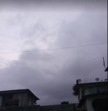
Monsoon clouds in Gangtok
-
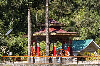
Banjhakri Falls and Energy Park, Gangtok
-
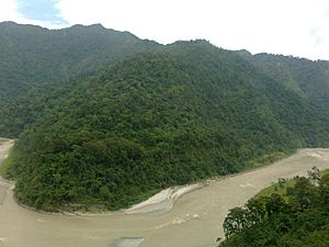
River Teesta is very important for Gangtok
-
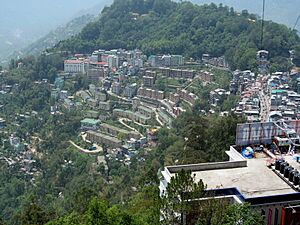
An overhead view of Gangtok from the ropeway facility


Gangtok's Economy

Tourism is a huge part of Gangtok's economy. Many people in Gangtok work in hotels and restaurants, or own them. Summer and spring are the busiest times for tourists.
Mahatma Gandhi Marg and Lal Market are popular business and tourist areas. Ecotourism is also growing, with activities like trekking, mountaineering, and river rafting. In 2007, about 351,000 tourists visited Sikkim, bringing in a lot of money.
The Nathula Pass, about 50 km (31 miles) from Gangtok, was once a major trade route with Tibet. This helped Gangtok's economy until 1962, when the border closed due to the Sino-Indian War. When the pass reopened in 2006, it helped boost the economy again. Sikkim's mountains make it hard for big factories to develop. The government is the biggest employer in the city.
Gangtok has a good Cottage industry for things like watch-making and handicrafts. Handmade paper from plant fibers is a special craft. The main market is where many rural people sell their farm produce. Sikkim is also a special region where people don't have to pay income tax. The Indian army has a large presence nearby, which also helps the local economy.
Agriculture is a big part of Sikkim's economy. In 2016, Sikkim became the first Indian state to be 100% organic in its farming. This creates new chances for selling products and for agritourism.
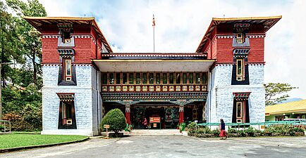
How Gangtok is Governed
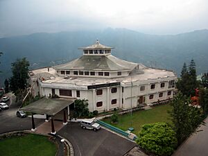
-
The "White Hall" complex houses the homes of the Chief Minister and Governor of Sikkim.
-
Sikkim Legislative Assembly in Gangtok. Fog is common here.


Gangtok is managed by the Gangtok Municipal Corporation (GMC) and other government departments. These groups handle things like garbage collection, water supply, and taxes. Gangtok is also the main office for the East Sikkim district.
The Sikkim High Court, India's smallest High Court, is located in Gangtok. The city's police are part of the state police force. Sikkim is known for having a very low crime rate.
City Services
The Government of Sikkim provides electricity to Gangtok. The city has a steady power supply thanks to many hydroelectric power stations in Sikkim. Roads outside Gangtok are kept up by the Border Roads Organisation, part of the Indian army.
Most homes get water from a central system managed by the PHED. The main water source is the Rateychu River, about 16 km (10 miles) from the city. This river is fed by snow and has clean water.
About 40% of homes have access to sewers for toilet waste. However, other wastewater often goes into open drains. The city's waste goes into the Ranikhola and Roro Chu rivers, which then flow into the Teesta River. The city produces about 45 tonnes of solid waste daily, but only about 40% is collected. The rest is often thrown into drains or valleys. The collected waste goes to a dump about 20 km (12 miles) away. There is a statewide ban on plastic bags in Sikkim.
Getting Around Gangtok
-
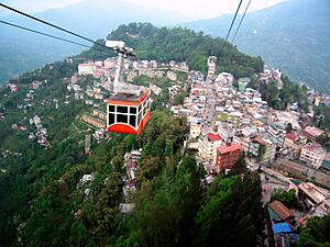
Gangtok cable car
-
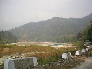
The Teesta River runs along the National Highway 31A connecting Gangtok to Siliguri.
-
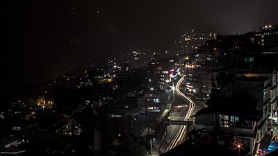
National Highway 31A at night.


Roads in Gangtok
Taxis are the most common way to get around Gangtok. Many people also own their own two-wheelers and cars. Personal vehicles and taxis make up 98% of all vehicles in Gangtok. City buses are not very common. For longer trips, people often use shared jeeps. Four wheel drives are helpful for the steep roads.
A 1 km (0.6 mile) long cable car connects different parts of Gangtok, from the lower areas to the city center and upper areas.
Gangtok is connected to the rest of India by National Highway 10 (NH10). This highway links Gangtok to Siliguri in West Bengal, which is about 114 km (71 miles) away. The highway also connects Gangtok to nearby hill towns like Darjeeling and Kalimpong. Regular jeep, van, and bus services run between these towns and Gangtok. Most roads in Gangtok are two lanes wide with sidewalks on one side. The steep slopes and winding roads can make traffic difficult.
Train Travel to Gangtok
The closest train station to Gangtok is New Jalpaiguri Junction railway station (NJP) in Siliguri, about 124 km (77 miles) away. Another nearby station is Siliguri Junction. Many trains connect Siliguri to Kolkata and other parts of Northeast India. There are plans to build a new railway line from Sevoke in West Bengal to Rangpo in Sikkim, which will eventually extend to Gangtok.
Flying to Gangtok

Pakyong Airport is located about 35 km (22 miles) south of Gangtok. It is one of India's highest airports, at 1,372 meters (4,500 feet) above sea level. It was the first new airport built in Northeast India and the 100th airport to open in India. It is also the only airport in Sikkim.
The airport opened on September 24, 2018. The first commercial flights started on October 4, 2018, connecting Pakyong to Kolkata.
People of Gangtok
| Historical population | ||
|---|---|---|
| Year | Pop. | ±% |
| 1951 | 2,744 | — |
| 1961 | 6,848 | +149.6% |
| 1971 | 13,308 | +94.3% |
| 1981 | 36,747 | +176.1% |
| 1991 | 25,024 | −31.9% |
| 2001 | 29,354 | +17.3% |
| 2011 | 98,658 | +236.1% |
| Population 1951–2011. Negative growth attributed to reduction of notified town limits. | ||
In 2011, Gangtok's population was about 98,658 people. Slightly more than half were male (53%), and 47% were female. Gangtok has a high literacy rate of 82.17%, which is better than the national average in India.
Many people have moved to Gangtok because of better job opportunities and services. This has put pressure on the city's resources.
The majority of people in Gangtok are Nepalis, who came to the region during British rule. Lepchas, who are native to the land, and Bhutias also make up a good part of the population. Many Tibetans have also moved to Gangtok. Other groups include Marwaris, Bhojpuris, and Bengalis.
| Religion in Gangtok city (2011) | ||||
|---|---|---|---|---|
| Hinduism | 58.81% | |||
| Buddhism | 28.15% | |||
| Christianity | 9.07% | |||
| Islam | 3.14% | |||
| Other or not stated | 0.83% | |||
Languages spoken in Gangtok City (2011) Nepali (59.01%) Hindi (14.13%) Bhutia (10.11%) Bhojpuri (2.74%) Bengali (2.71%) Lepcha (2.68%) Tibetan (1.04%) Tamang (1.01%) Sherpa (0.90%) Limbu (0.84%) Marwari (0.72%) Urdu (0.60%) Marathi (0.42%) Odia (0.34%) Malayalam (0.33%) Rai (0.28%) Telugu (0.23%) Assamese (0.19%) Tamil (0.18%) Manipuri (0.18%) Maithili (0.11%) Others (1.29%)
Hinduism and Buddhism are the main religions in Gangtok. There are also Christians and a small number of Muslims. The city has churches and a mosque for these groups. Gangtok has a history of peace between different religions.
Nepali is the most spoken language. English and Hindi are also widely spoken and understood. Other languages include Bhutia (Sikkimese), Tibetan, and Lepcha.
Gangtok's Culture and Fun Facts
-
The Namgyal Institute of Tibetology Museum shows rare Lepcha tapestries and Buddhist statues.
-
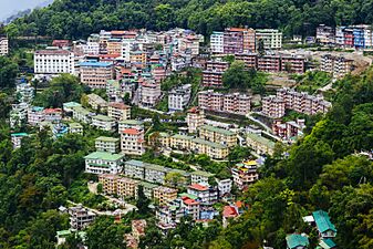
View of downtown Gangtok city from Crown Prince Tenzing Kunzang Namgyal Walkway.
-
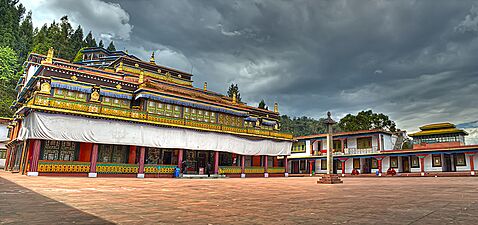
Rumtek Monastery, near Gangtok, is a very holy Buddhist monastery.


Besides major festivals like Dashain, Tihar, Christmas, and Holi, Gangtok celebrates many local festivals. The Lepchas and Bhutias celebrate their new year in January. Tibetans celebrate their new year (Losar) with "Devil Dance" in January or February. Other important festivals include Maghe sankranti, Ram Navami, Chotrul Duchen, Buddha Jayanti, and Saga Dawa.
A popular food in Gangtok is the momo, which is a steamed dumpling filled with meat or vegetables. Wai-Wai is a packaged noodle snack. Thukpa, a noodle soup, is also popular. Other noodle dishes like chowmein and wonton are available. Traditional Sikkimese foods include shah-phaley (patties with spiced meat) and Gack-ko soup. Restaurants offer Indian, continental, and Chinese food. Churpee, a hard cheese made from cow or yak milk, is sometimes chewed. Chhang is a local millet beer, often served in bamboo cups.
Football (soccer), cricket, and archery are the most popular sports. The Paljor Stadium is the main sports ground. Thangka is a special handicraft: a hand-painted religious scroll on fabric. Chhaams are colorful monastic dances performed during festivals, especially during the Tibetan new year.
Important Places to Visit
Gangtok is a center for Buddhist learning and culture. Key Buddhist sites include the Enchey monastery, the Do-drul Chorten stupa, and the Rumtek Monastery. The Enchey monastery is the oldest in the city, housing images of gods and religious items. In January, a masked dance called Chaam is performed there.
The Do-drul Chorten is a stupa built in 1945. It contains holy relics, books, and mantras. Around it are 108 Mani Lhakor, or prayer wheels. This complex also has a religious school.
The Rumtek Monastery, just outside Gangtok, is one of Buddhism's most sacred monasteries. It holds some of the world's rarest Tibetan Buddhist scriptures. Built in the 1960s, it looks like a monastery in Lhasa, Tibet.
The Namgyal Institute of Tibetology, also known as the Tibetology Museum, has a large collection of masks, Buddhist scriptures, statues, and tapestries. It is a place to study Buddhist ideas. Gonjang Monastery, built in 1981, is about 9 kilometers from the city center. It has beautiful Tibetan architecture, golden statues, and a large prayer wheel. It also offers amazing mountain views.
The Thakurbari Temple, built in 1935, is one of the oldest and most famous Hindu temples in the city. The Ganesh Tok and the Hanuman Tok are temples dedicated to the Hindu gods Ganpati and Hanuman, located higher up in the city.
The Himalayan Zoological Park shows animals from the Himalayas in their natural homes. You can see the Himalayan black bear, red pandas, barking deer, snow leopard, and Tibetan wolf. The Jawaharlal Nehru Botanical Gardens, near Rumtek, has many types of orchids and over fifty different kinds of trees, including many oaks.
Education in Gangtok
Schools in Gangtok are run by the state government or by private and religious groups. They mainly teach in English and Nepali. Schools follow different national education boards in India. Some well-known schools include Tashi Namgyal Academy and Holy Cross School.
For higher education, there are colleges like Sikkim Government College. Sikkim University, started in 2007, is in Gangtok and offers many courses. The Sikkim Manipal University is also nearby, with its medical and technology institutes. The Indira Gandhi National Open University has a center here too. There are also places that offer diplomas in Buddhist studies and other special fields.
Media and Communication
More than 50 newspapers are published in Sikkim. Local Nepali and English newspapers are common, and national newspapers from other parts of India are also available.
Gangtok has two cinemas that show Nepali, Hindi, and English movies. There is also a public library.
For TV, the main providers are Sikkim Cable, Nayuma, Dish TV, and Doordarshan. All India Radio has a local station in Gangtok. There are also three FM radio stations. The biggest mobile networks in Gangtok are BSNL, Vodafone, Jio, and Airtel, all offering 4G services.
Images for kids
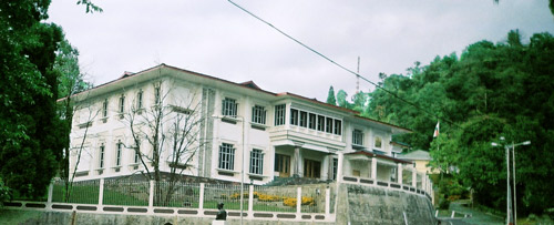
-
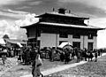
Temple of the Maharajas, Gangtok. 1938.
-
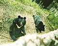
The Himalayan black bear is seen here in the Himalayan Zoological Park.


See also
 In Spanish: Gangtok para niños
