
Fog facts for kids

Fog is like a very thick cloud that forms close to the ground. You might see it on land or over the sea. Fog makes it hard to see far ahead, which is called low visibility. When fog forms high up in the sky, it's actually a type of cloud called a stratus cloud. Fog happens when the air gets cold and the moisture in it turns into tiny water droplets.
Fog is made of millions of tiny water droplets. If it's very cold, it can even be tiny ice crystals. Imagine looking at it with a super slow-motion camera! You would see countless small water drops floating in the air. These tiny droplets are what make up fog or mist. There are different kinds of fog, like radiation fog, advection fog, and evaporation fog. How thick the fog is depends on the air, temperature, weather, and where you are.
Contents
How Fog Forms


Fog starts to form when the air temperature gets very close to the dew point. The dew point is the temperature at which the air can no longer hold all its water vapor, and it starts to turn into liquid. This usually happens when the difference between the air temperature and the dew point is less than 2.5 °C or 4 °F.
Fog forms when water vapor in the air condenses into tiny liquid water droplets. These droplets then float in the air. Water vapor can be added to the air in many ways. For example, water evaporates from oceans, lakes, or wet ground when the sun heats them. Plants also release water vapor into the air. When cool or dry air moves over warmer water, it can pick up moisture. Air also gets moisture when it moves up mountains.
Water vapor usually needs tiny particles to stick to when it condenses. These particles are called condensation nuclei, and they can be dust, ice, or salt. Fog is a lot like a stratus cloud, which is a flat, low-lying cloud. Both tend to form when a cool, stable air mass is trapped under a warmer air mass.
Fog usually appears when the relative humidity is close to 100%. This means the air is holding almost as much water vapor as it possibly can. If more moisture is added, or if the air cools down, fog can form. Sometimes, fog can form very quickly, which is called "flash fog." It can also disappear just as fast.
Fog can sometimes cause light rain or very light snow. This happens when the tiny water droplets in the fog join together to form larger drops. If the temperature is below freezing, these drops can become freezing drizzle when they hit surfaces.
The height of a fog layer depends on something called an "inversion boundary." This is where warmer, drier air sits above the cooler, moist air that forms the fog. When the air pressure is high, the fog layer can be "squashed" down. When the pressure drops, the fog layer can expand upwards.
Types of Fog

.jpg)
Fog can form in several ways, depending on how the air cools down and causes water vapor to condense.
Radiation Fog
Radiation fog forms after the sun sets, usually on clear, calm nights. The ground cools down by releasing heat into the air. This cool ground then cools the air right above it. When this air cools below its dew point, fog forms. If there's no wind, the fog layer can be very thin, sometimes less than a meter deep. But if there's a little bit of wind, it can make the fog layer thicker. Radiation fogs usually happen at night and often disappear soon after sunrise. However, in winter, they can sometimes last all day, especially in valleys. This type of fog is most common in autumn and early winter. An example is the Tule fog in California.
Ground Fog
Ground fog is a type of fog that doesn't cover the whole sky. It usually means the fog is very shallow, sometimes only a few centimeters deep, especially when there's no wind. It's often another name for very shallow radiation fog.
Advection Fog

Advection fog forms when moist air moves over a cooler surface. This often happens at sea when warm, moist air blows over colder ocean water. It's very common along the California coast, where cold water rises from the deep ocean. It can also happen when warm, moist air moves over land that has a lot of snow.
Even strong winds can sometimes create advection fog. If very warm and humid air blows over a snow-covered area, it can still form fog, even at high speeds. This fog will be turbulent and relatively shallow.
Along the California coast, advection fog is often pushed inland by different weather patterns. A cold front can push the fog from the ocean onto land, which often happens in spring or late fall. In summer, intense heat inland creates a low-pressure area that pulls the dense ocean fog towards the coast. Also in summer, high pressure over the desert can cause winds that push the offshore fog up the coastline. This is called a "southerly surge" and usually follows a period of hot weather on the coast. However, if the winds are too strong, they can break up the fog. Moderate winds can lift the fog and turn it into shallow, lumpy clouds called stratocumulus.
Evaporation Fog
Evaporation fog, also known as steam fog, forms over bodies of water that are much warmer than the air above them. You might see this over lakes or rivers on a cold morning. This situation can also create "steam devils," which look like small dust devils made of fog. Lake effect fog is often this type. Unlike most other fogs, evaporation fog can be very dense and look fluffy from above.
Frontal Fog
Frontal fog forms near a weather front. This happens when raindrops fall from warmer air above the front into cooler air closer to the ground. The raindrops evaporate into the cooler air, making it saturated. When the air becomes saturated, fog forms.
Ice Fog
Ice fog forms in very cold temperatures. It can be caused by other fog types or even by the breath of animals in large herds. It's sometimes seen with a type of precipitation called diamond dust, which is made of tiny ice crystals slowly falling. This often happens on clear, sunny days and can create beautiful halos and other light effects as sunlight passes through the ice crystals.
Freezing Fog
Freezing fog is made of tiny water droplets that are "supercooled." This means they are still liquid even though the temperature is below freezing. When these droplets touch a surface, they instantly freeze, forming a white, feathery ice called rime.
Precipitation Fog
Precipitation fog, also called frontal fog, forms when rain or snow falls from a cloud into drier air below. As the liquid droplets evaporate into water vapor, the air cools down. When the air reaches its dew point, the water vapor condenses, and fog forms.
Hail Fog
Hail fog can sometimes form near large piles of hail. This happens because the hail cools the air and adds moisture, making the air very humid in a shallow layer near the ground. It's most common when there's warm, humid air above the hail and the wind is light. This ground fog is usually localized but can be very dense and appear suddenly. It forms as the hail cools the air and absorbs heat while melting and evaporating.
Upslope Fog
Upslope fog forms when moist air moves up the side of a mountain or hill. As the air rises, it cools down. This cooling causes the water vapor in the air to condense and form fog.
Images for kids
-
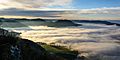
View from Blassenstein mountain near Scheibbs (Lower Austria) with fog over Erlauf valley and the Danube.
-
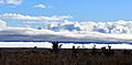
A huge fog bank over Twentynine Palms, California, covering the whole city as it rises to join the clouds.
-
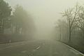
Heavy fog on a road near Baden, Austria.
-
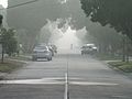
Light fog on a suburban street, making a cyclist look hazy at about 200 m (220 yd). You can see about 400 m (440 yd) down the street.
-
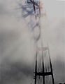
Sutro Tower casting a 3D shadow in the fog.
-
Morning freezing fog in Elko, Nevada.
-
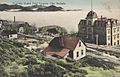
Pogonip fog in Virginia City, Nevada, from an early 1900s postcard.
-
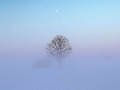
A tree in a field during very cold weather with frozen fog.
-
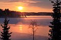
Ice fog on Pyhäjärvi lake in Tampere, Finland, during sunset.
-
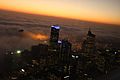
Fog rolling into Seattle from the sea.
-
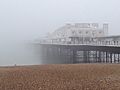
Sea fog, also called "fret," moving towards Brighton Pier.
-
Sea fog in the Arctic Ocean near the island of Jan Mayen.
-
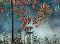
A maple tree with red autumn leaves in the morning mist in western Estonia.
-
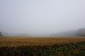
Fog on the fields of Leppälahti and Kuivaniemi villages in Kuopio, Finland.
-
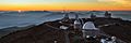
Fog hovering over the valleys around La Silla Observatory.
-
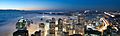
Fog surrounding skyscrapers in the Melbourne city centre.
-

Light fog over Taipei, Taiwan, with Taipei 101 in the background.
-
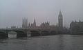
Fog in London with the Palace of Westminster in the background.
-
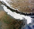
Dense fog over the Indian subcontinent, seen by NASA's Aqua satellite in December 2012.


See also
 In Spanish: Niebla para niños
