
Lower Austria facts for kids
Quick facts for kids
Lower Austria
Niederösterreich
|
|||
|---|---|---|---|
|
|||
 |
|||
| Country | |||
| Capital | Sankt Pölten | ||
| Area | |||
| • Total | 19,186.27 km2 (7,407.86 sq mi) | ||
| Population
(1 January 2016)
|
|||
| • Total | 1,653,419 | ||
| • Density | 86.17720/km2 (223.19792/sq mi) | ||
| Time zone | UTC+1 (CET) | ||
| • Summer (DST) | UTC+2 (CEST) | ||
| ISO 3166 code | AT-3 | ||
| NUTS Region | AT1 | ||
| Votes in Bundesrat | 12 (of 62) | ||
| Website | www.noe.gv.at | ||


Lower Austria (in German, Niederösterreich) is a large region, or 'state,' in the country of Austria. It's located in the northeast part of Austria. It's the biggest state in Austria by land area and the second biggest by how many people live there. It's also a very old and important part of Austrian history.
About 1.7 million people call Lower Austria home, living across an area of about 19,000 square kilometers.
The capital city of Lower Austria is Sankt Pölten. It became the capital in 1986, taking over from Vienna. Sankt Pölten is also the biggest city in the state, followed by Wiener Neustadt.
Lower Austria shares borders with other Austrian states. To the west is Upper Austria, to the south is Styria, and to the southeast is Burgenland. The city-state of Vienna is located right in the middle of Lower Austria.
It also borders other countries. To the north, it meets the Czech Republic, and to the east, it borders Slovakia.
The famous Danube River flows through Lower Austria. It divides the state into two main parts. The northern part includes the regions of Waldviertel and Weinviertel. The southern part has the regions of Mostviertel and Industrieviertel. These regions are further divided into 21 districts, which contain 573 towns.
The northern part of Lower Austria has many hills. The hills in the Waldviertel are part of the Manhartsberg ridge. Those in the Weinviertel are smaller parts of the Carpathian Mountains.
The southern part is more mountainous, with parts of the Alps. These include the Styrian-Lower Austrian Limestone Alps and the Vienna Woods (Wienerwald). The highest mountain in Lower Austria is the Schneeberg, which is 2,076 meters tall.
Lower Austria is mostly a rural area. About 42% of its land is used for farming, and 40% is covered by forests. Winegrowing is very popular, especially in areas like Wachau, Weinviertel, and the Thermenregion.
About 80% of the people living in Lower Austria are Roman Catholic.
Contents
Governing Lower Austria
This section explains how Lower Austria is governed and which political groups are involved.
The Parliament of Lower Austria
Lower Austria has its own parliament, which makes decisions for the state. In the elections of 2013, 56 seats were taken by different political groups:
Who Leads the State?
Lower Austria is currently governed by a partnership, or 'coalition,' between the ÖVP and SPÖ parties. The leader of the state, called the Governor, has been Johanna Mikl-Leitner from the ÖVP party since April 2017.


Burgenland · Carinthia · Lower Austria · Salzburg(erland) · Styria · Tyrol · Upper Austria · Vienna · Vorarlberg
Images for kids
-
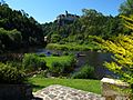
Kamp river below the Rosenburg castle
-
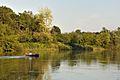
March river with riparian forest
-
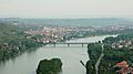
View of Krems (left) at the end of Wachau valley; Danube river in the center


See also
 In Spanish: Baja Austria para niños
