
Carinthia (state) facts for kids
Quick facts for kids
Carinthia
Kärnten
Koroška Carinzia |
|||
|---|---|---|---|
|
|||
 |
|||
| Country | |||
| Capital | Klagenfurt | ||
| Area | |||
| • Total | 9,538.01 km2 (3,682.65 sq mi) | ||
| Population
(1 January 2016)
|
|||
| • Total | 560,300 | ||
| • Density | 58.744/km2 (152.146/sq mi) | ||
| Time zone | UTC+1 (CET) | ||
| • Summer (DST) | UTC+2 (CEST) | ||
| ISO 3166 code | AT-2 | ||
| NUTS Region | AT2 | ||
| Votes in Bundesrat | 4 (of 62) | ||
| Website | www.ktn.gv.at | ||


Carinthia is a beautiful state in the south of Austria. It is located in the Eastern Alps, a famous mountain range. Most people in Carinthia speak German.
Carinthia is known for its many important jobs and businesses. These include tourism, which means lots of visitors come to enjoy the area. Other key industries are electronics, engineering, forestry, and agriculture. Big companies like Philips and Siemens have large operations here, providing many jobs.
Contents
Exploring Carinthia's Regions
Carinthia is divided into different areas called districts. These districts help organize the state. There are eight rural districts and two urban districts. In total, Carinthia has 132 towns.

Main Cities in Carinthia
These are the two largest and most important cities in Carinthia:
Rural Districts of Carinthia
These districts cover the more countryside and smaller towns:
- Spittal an der Drau
- Hermagor
- Villach-Land
- Feldkirchen
- St. Veit an der Glan
- Klagenfurt-Land
- Völkermarkt
- Wolfsberg
Burgenland · Carinthia · Lower Austria · Salzburg(erland) · Styria · Tyrol · Upper Austria · Vienna · Vorarlberg
Images for kids
-
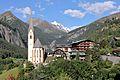
Heiligenblut with Grossglockner (snow-capped peak in the central background)
-
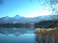
Lake Faak and the Karawanks
-
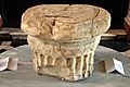
Prince's Stone, exhibited at the Landhaus Klagenfurt
-
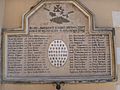
War memorial commemorating soldiers from the village of Obermillstatt who died in World War I
-
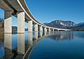
Road bridge across the Ferlach reservoir of the Drava River at Unterschlossberg, Koettmannsdorf, Klagenfurt, Carinthia, Austria
-
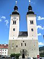
Gurk Cathedral
.JPG)


See also
 In Spanish: Carintia para niños
