Twentynine Palms, California facts for kids
Quick facts for kids
Twentynine Palms, California
|
|||
|---|---|---|---|
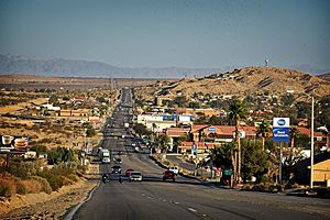
Twentynine Palms looking east on Highway 62
|
|||
|
|||
| Motto(s):
"A Beautiful Desert Oasis"
|
|||
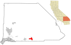
Location in San Bernardino County and California
|
|||
| Country | |||
| State | |||
| County | |||
| Incorporated | November 23, 1987 | ||
| Government | |||
| • Type | Council–manager | ||
| Area | |||
| • Total | 58.76 sq mi (152.18 km2) | ||
| • Land | 58.76 sq mi (152.18 km2) | ||
| • Water | 0 sq mi (0 km2) 0% | ||
| Elevation | 1,988 ft (606 m) | ||
| Population
(2020)
|
|||
| • Total | 28,065 | ||
| • Density | 477.62/sq mi (184.420/km2) | ||
| Time zone | UTC−8 (Pacific) | ||
| • Summer (DST) | UTC−7 (PDT) | ||
| ZIP codes |
92277-92278
|
||
| Area codes | 442/760 | ||
| FIPS code | 06-80994 | ||
| GNIS feature IDs | 1652804, 2412119 | ||
Twentynine Palms (also known as 29 Palms) is a city in San Bernardino County, California. It is a main entrance to Joshua Tree National Park. The city is known for its desert views and connection to nature.
Contents
History of Twentynine Palms
Native American tribes like the Serrano, Chemehuevi, and Cahuilla lived in this area long ago. Colonel Henry Washington was one of the first explorers to write about Twentynine Palms. He found Chemehuevi people living near a spring they called "Mar-rah," which means "Oasis of Mara."
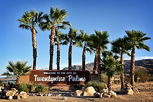
The city got its name from 29 Washingtonia filifera palm trees. The Serrano people planted these trees around the Oasis of Mara. A post office was opened here in 1927.
A road called Utah Trail honors early pioneers. They traveled this trail from Utah to Twentynine Palms in the late 1800s. There is also a small Indian reservation nearby.
Joshua Tree National Park is just south of Twentynine Palms. It became a national monument in 1936 and a national park in 1994. The Marine Corps Air Ground Combat Center Twentynine Palms was built nearby in 1952.
People of Twentynine Palms
| Historical population | |||
|---|---|---|---|
| Census | Pop. | %± | |
| 1970 | 5,667 | — | |
| 1980 | 7,465 | 31.7% | |
| 1990 | 11,821 | 58.4% | |
| 2000 | 14,764 | 24.9% | |
| 2010 | 25,048 | 69.7% | |
| 2019 (est.) | 26,073 | 4.1% | |
| U.S. Decennial Census | |||
In 2020, about 28,065 people lived in Twentynine Palms.
Population in 2010
In 2010, there were 25,048 people living in the city. Most people lived in homes, while some lived in group housing. About 25.6% of the people were under 18 years old. The average age was 23.5 years.
Geography and Climate
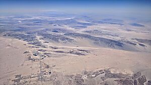
Twentynine Palms is in the Mojave Desert in Southern California. It is on the northern edge of Joshua Tree National Park. One of the park's entrances is located here, at the Oasis of Mara.
The city covers about 59.1 square miles (153.1 km2) of land. It is about 1,988 feet (606 meters) above sea level. The Marine Corps Air Ground Combat Center Twentynine Palms is also located in the city.
Weather in Twentynine Palms
Twentynine Palms has a desert climate. Because it is high up, winters are a bit cooler than in places like Palm Springs. Summers are very hot.
Temperatures often reach 100°F (38°C) on about 89 days each year. They can reach 90°F (32°C) on 154 days. Freezing temperatures happen about 17 nights a year. The hottest temperature ever recorded was 118°F (48°C) in July 1961. The coldest was 10°F (-12°C) in December 1990.
August is usually the wettest month, with some rain from summer thunderstorms.
| Climate data for Twentynine Palms, California, 1991–2020 normals, extremes 1935–present | |||||||||||||
|---|---|---|---|---|---|---|---|---|---|---|---|---|---|
| Month | Jan | Feb | Mar | Apr | May | Jun | Jul | Aug | Sep | Oct | Nov | Dec | Year |
| Record high °F (°C) | 85 (29) |
90 (32) |
95 (35) |
102 (39) |
112 (44) |
117 (47) |
118 (48) |
116 (47) |
114 (46) |
106 (41) |
93 (34) |
86 (30) |
118 (48) |
| Mean maximum °F (°C) | 74.3 (23.5) |
78.1 (25.6) |
86.9 (30.5) |
95.0 (35.0) |
101.8 (38.8) |
109.6 (43.1) |
112.4 (44.7) |
110.5 (43.6) |
105.4 (40.8) |
96.6 (35.9) |
83.9 (28.8) |
73.9 (23.3) |
113.3 (45.2) |
| Mean daily maximum °F (°C) | 63.3 (17.4) |
67.2 (19.6) |
74.1 (23.4) |
81.1 (27.3) |
89.9 (32.2) |
99.4 (37.4) |
104.0 (40.0) |
102.7 (39.3) |
96.5 (35.8) |
84.7 (29.3) |
71.6 (22.0) |
62.0 (16.7) |
83.0 (28.3) |
| Daily mean °F (°C) | 52.6 (11.4) |
55.7 (13.2) |
61.7 (16.5) |
67.8 (19.9) |
76.4 (24.7) |
85.1 (29.5) |
90.7 (32.6) |
89.6 (32.0) |
82.9 (28.3) |
71.2 (21.8) |
59.3 (15.2) |
50.9 (10.5) |
70.3 (21.3) |
| Mean daily minimum °F (°C) | 41.8 (5.4) |
44.1 (6.7) |
49.3 (9.6) |
54.5 (12.5) |
62.9 (17.2) |
70.7 (21.5) |
77.4 (25.2) |
76.4 (24.7) |
69.3 (20.7) |
57.8 (14.3) |
47.0 (8.3) |
39.9 (4.4) |
57.6 (14.2) |
| Mean minimum °F (°C) | 28.6 (−1.9) |
30.6 (−0.8) |
35.8 (2.1) |
41.0 (5.0) |
48.8 (9.3) |
56.7 (13.7) |
66.8 (19.3) |
64.4 (18.0) |
55.7 (13.2) |
42.9 (6.1) |
31.8 (−0.1) |
27.0 (−2.8) |
25.0 (−3.9) |
| Record low °F (°C) | 11 (−12) |
18 (−8) |
23 (−5) |
24 (−4) |
33 (1) |
43 (6) |
53 (12) |
52 (11) |
38 (3) |
24 (−4) |
14 (−10) |
10 (−12) |
10 (−12) |
| Average precipitation inches (mm) | 0.50 (13) |
0.56 (14) |
0.35 (8.9) |
0.12 (3.0) |
0.05 (1.3) |
0.00 (0.00) |
0.40 (10) |
0.65 (17) |
0.34 (8.6) |
0.15 (3.8) |
0.19 (4.8) |
0.56 (14) |
3.87 (98) |
| Average precipitation days (≥ 0.01 in) | 3.9 | 3.2 | 2.3 | 1.0 | 0.6 | 0.1 | 1.7 | 2.3 | 1.7 | 1.1 | 1.0 | 2.2 | 21.1 |
| Source: NOAA | |||||||||||||
Fun Things to Do
The city has 26 outdoor murals painted on buildings. These murals show different parts of desert life and history.
The 29 Palms Historical Society has a museum in the old schoolhouse. It tells the story of the area. They also have a yearly "Weed Show" in November. Artists create art using desert plants. The Twentynine Palms Artists' Guild shows art by local artists.
What Drives the Economy
The Oasis of Mara was the first water source in the area. It was important for all early activities. Today, part of the oasis is near the Joshua Tree National Park Visitor's Center. Many people visit the park each year. The other part of the oasis belongs to the 29 Palms Inn, a historic hotel.
The city's economy mainly relies on the Marine Corps Air Ground Combat Center. Tourism from Joshua Tree National Park is also very important. Many people rent vacation homes here.
Schools and Learning
- Copper Mountain College is a college for the local area.
- The Morongo Unified School District runs the public schools.
- Mayfield College offers training for military members. They learn about heating and air conditioning.
Media and News
The Desert Trail is a newspaper published weekly in Yucca Valley. The Sun Runner Magazine is published every two months. It is about desert life and culture.
There are also local TV and radio stations. These stations provide news and entertainment for the community.
Getting Around
 State Route 62 goes through the city from east to west.
- Buses are available through the Morongo Basin Transit Authority (MBTA).
- The closest airport for passengers is Palm Springs Airport (PSP).
Famous People from Twentynine Palms
- Brant Bjork, a musician who lives here.
- Willie Boy, a Native American whose story became a book and a movie. He was born in 29 Palms.
- Doug Cockle, an actor and director.
- Conrad Dobler, a former NFL player who went to high school here.
- Dick Dale, known as the "king of the surf guitar," lived here until he passed away.
- Mike Evans, an actor and writer who lived here for a long time.
- Huell Howser, a TV personality known for "California's Gold."
- Carrie Ann Lucas, a lawyer and activist for disability rights.
- Bryan D. O'Connor, a retired Marine Corps colonel and former NASA astronaut.
- Cliff Raven, a pioneer in tattooing, lived and worked here later in his life.
- Elizabeth Warder Crozer Campbell, an archaeologist who found many artifacts in Joshua Tree Park.
- Paramahansa Yogananda, an Indian yoga master who had a retreat here.
See also
 In Spanish: Twentynine Palms para niños
 | James Van Der Zee |
 | Alma Thomas |
 | Ellis Wilson |
 | Margaret Taylor-Burroughs |


