
Southern California facts for kids
Quick facts for kids
Southern California
|
|
|---|---|
|
Images top to bottom, left to right: Hermosa Beach Pier, Disneyland Resort, Village of La Jolla, Santa Monica Pier, Surfer at Black's Beach, Hollywood Sign, Downtown Los Angeles, San Diego Skyline
|
|

Red: The ten counties of Southern California
|
|
| Country | United States |
| State | California |
| Counties | Imperial Kern Los Angeles Orange Riverside San Bernardino San Diego San Luis Obispo Santa Barbara Ventura |
| Largest city | Los Angeles |
| Area
(10-county)
|
|
| • Total | 56,505 sq mi (146,350 km2) |
| Population
(2020)
|
|
| • Total | 23,762,904 |
| GDP | |
| • Total | $1.95 trillion (2022) |
_(cropped).jpeg)


.jpg)


Southern California (often called SoCal) is a large area in the southern part of the U.S. state of California. It's known for its unique geography and culture. This region includes the huge Los Angeles metropolitan area, which is one of the biggest city areas in the United States. It also has the Inland Empire, another large metropolitan area.
Southern California usually includes ten of California's 58 counties. These are Imperial, Kern, Los Angeles, Orange, Riverside, San Bernardino, San Diego, Santa Barbara, San Luis Obispo, and Ventura counties.
Even though it's smaller than Northern California in land size, Southern California has more people. About 23.76 million people lived here in 2020. A big part of the area is covered by deserts. The Colorado Desert is on the eastern border with Arizona. The Mojave Desert borders Nevada to the northeast. Southern California's border with Baja California is part of the Mexico–United States border.
Contents
- Major City Areas in Southern California
- Why is Southern California Important?
- Where is Southern California?
- Cities and Counties of Southern California
- What is the Economy Like?
- How People Get Around: Transportation
- Communication: Phone Area Codes
- Colleges and Universities
- Parks and Outdoor Fun
- Sports Teams in Southern California
- Images for kids
- See also
Major City Areas in Southern California
Southern California is home to many large city areas. These are called metropolitan areas. Three of these areas together form the Greater Los Angeles region. This region has over 18 million people. It is the second-largest combined city area in the U.S.
What are the Main Metropolitan Areas?
- The Los Angeles metropolitan area includes Los Angeles and Orange counties. It has about 13.3 million people.
- The Inland Empire includes Riverside and San Bernardino counties. It has about 4.3 million people.
- The Oxnard–Thousand Oaks–Ventura metropolitan area has about 0.8 million people.
- The San Diego metropolitan area has about 3.3 million people.
- Other metro areas include Bakersfield, Santa Barbara, San Luis Obispo, and El Centro.
This entire Southern California Megaregion is even bigger. It stretches into Las Vegas, Nevada, and south into Tijuana, Mexico.
Why is Southern California Important?
Southern California has two very important cities: Los Angeles and San Diego. It also has three of the country's largest metropolitan areas.
Major Cities and Their Populations
- Los Angeles is the biggest city in California. It is the second-largest city in the United States. About 4 million people live there.
- San Diego is south of Los Angeles. It is the second-biggest city in California. About 1.4 million people live there. It is the eighth-largest city in the U.S.
The counties of Los Angeles, San Diego, Orange, Riverside, and San Bernardino are the five most populated in California. They are also among the top 15 most populated counties in the entire United States.


Entertainment and Culture Hub
The movie, TV, and music industries are mostly found in the Los Angeles area. Hollywood, a part of Los Angeles, is famous worldwide for American movies. Many big entertainment companies have their main offices here. These include The Walt Disney Company, Sony Pictures, Universal Pictures, MGM, Paramount Pictures, and Warner Bros.
Southern California is also a big center for surf and skateboard culture. Many popular brands like Vans and Volcom are based here. Famous skateboarders like Tony Hawk and surfers like Rob Machado live in the area. Some of the best surf spots in the world are here, such as Trestles and Huntington Beach. Big action sports events like the X Games are also held in Southern California.
The region is important for yachting too. The San Diego Yacht Club hosted the America's Cup races several times. The first modern triathlon race happened in San Diego in 1974. Since then, Southern California has become a major place for triathlon sports.
Popular Places to Visit
Many locals and tourists enjoy the beautiful beaches along the Southern California coast. Some popular beaches are Malibu, Laguna Beach, La Jolla, Manhattan Beach, and Hermosa Beach.
Southern California also has mountain towns like Big Bear Lake and Lake Arrowhead. These towns have ski resorts like Bear Mountain. The desert city of Palm Springs is also a popular spot.

Where is Southern California?
Southern California is generally considered the area south of 35°45' latitude. This is about one-third of the state. It includes the northern borders of San Luis Obispo, Kern, and San Bernardino counties. These borders are not perfectly straight.
Another way to define Southern California is by its natural barriers. These include Point Conception and the Tehachapi Mountains to the north.


Historical Attempts to Divide California
After the U.S. got California, some politicians wanted to split the state. They wanted to create a separate state in the south. This new state would have allowed slavery. However, the Compromise of 1850 made California a free state. This stopped the division.
Later, in the 1850s, people in Southern California tried three times to form their own state. They were unhappy with taxes and land laws. The last attempt was the Pico Act of 1859. It passed the state legislature and was approved by voters. This plan would have created the Territory of Colorado. But the start of the American Civil War stopped this plan from happening.
In 1900, the Los Angeles Times newspaper said Southern California included seven counties. These were Los Angeles, San Bernardino, Orange, Riverside, San Diego, Ventura, and Santa Barbara. This definition did not include San Luis Obispo and Kern counties.
More recently, in 2020, during the COVID-19 pandemic, the state government divided California into five regions. Southern California was one of these regions. It included Imperial, Los Angeles, Kern, Orange, Riverside, San Bernardino, San Diego, San Luis Obispo, Santa Barbara, and Ventura counties.
Cities and Counties of Southern California
Southern California has a population of 23,762,904 people as of 2020. Even though it's known for fast growth, its population has grown slower than the rest of California since the 2000s. This is because more growth has happened in Northern California. That area has a strong economy based on technology.
The region has two very large metropolitan areas. The Greater Los Angeles Area has over 17.7 million people. The San Diego–Tijuana area has over 5.1 million people.
Major Cities in Southern California

- Los Angeles is the largest city in California. It has about 3.9 million people.
- San Diego is the second largest city in California. It has almost 1.4 million people.
Southern California also has 14 cities with over 200,000 residents. There are 48 cities with over 100,000 residents. Many of the biggest cities are near the coast. Exceptions include San Bernardino and Riverside, which are inland.
Counties in Southern California
.jpg)
- Imperial
- Kern
- Los Angeles
- Orange
- Riverside
- San Bernardino
- San Diego
- San Luis Obispo
- Santa Barbara
- Ventura
What is the Economy Like?
Southern California has one of the biggest economies in the United States. It relies heavily on oil, especially because so many people use cars and highways.
Key Industries and Businesses
Southern California is famous for its tourism and the entertainment industry. Other important industries include:
- Software
- Automotive
- Aerospace
- Finance
- Biomedical
- Ports and shipping
From 2001 to 2007, the region saw a big increase in housing construction. This was called the housing bubble. The area was greatly affected when the housing market crashed.
Since the 1920s, movies, oil, and airplane making have been major industries. Farming, especially cattle and citrus, was also very important. But much of this farmland has been turned into suburbs. Even though military spending has decreased, the aerospace industry is still a big part of the economy.
Major Business Areas

Southern California has many important business districts. These include:
- Downtown Los Angeles
- Downtown Riverside
- Downtown San Bernardino
- Downtown San Diego
- The South Coast Metro
In the Los Angeles area, other business districts are Downtown Pasadena, Downtown Burbank, and Downtown Santa Monica. The area of Santa Monica and Venice is sometimes called "Silicon Beach." This is because many tech companies are located there.
In Orange County, there are large suburban business centers. These include the area around Anaheim and Santa Ana. Also, the area from the South Coast Metro to the Irvine Business Complex is important.
Downtown San Diego is the main business area for San Diego. But the city has many other business districts. These include Carmel Valley and Mission Valley.
Fun Theme Parks and Water Parks
Southern California is home to many famous theme parks and water parks:
- Los Angeles Area
- Orange County Area
- San Diego Area
How People Get Around: Transportation
Southern California has a very busy transportation system.
Airports
The region has several major airports:
- Los Angeles International Airport (LAX) is the second-busiest airport in the U.S.
- San Diego International Airport is the busiest single-runway airport in the world.
- Van Nuys Airport is the busiest airport for private planes.
- Other important airports are in San Bernardino, Orange County, Bakersfield, Ontario, Burbank, and Long Beach.
Freeways and Highways

Southern California is known for its large system of freeways. Many of these freeways are called by names instead of just their numbers. For example, Interstate 5 is also known as the Golden State Freeway or San Diego Freeway. Interstate 10 is called the Santa Monica Freeway or San Bernardino Freeway.
Public Transportation

Southern California has public transportation options. The Metrolink train system connects many counties. These include Los Angeles, Ventura, San Bernardino, Riverside, Orange, and San Diego counties.
The region also has major ports. The Port of Los Angeles is the busiest commercial port in the country. The nearby Port of Long Beach is the second busiest container port. The Port of San Diego is also important.
Communication: Phone Area Codes
Southern California uses many different telephone area codes. Each code covers a specific part of the region.
- 213 and 323 cover Central Los Angeles.
- 310 and 424 cover West Los Angeles and the South Bay.
- 562 covers Long Beach and parts of northern Orange County.
- 619 and 858 cover most of San Diego County.
- 626 covers most of the San Gabriel Valley.
- 661 covers Bakersfield and the Antelope Valley.
- 714 and 657 cover northern Orange County.
- 760 and 442 cover northern San Diego County, Imperial County, and desert areas.
- 805 and 820 cover Santa Barbara, Ventura, and San Luis Obispo Counties.
- 818 covers the San Fernando Valley.
- 909 and 840 cover southwestern San Bernardino County and parts of Riverside County.
- 949 covers southern Orange County.
- 951 covers western Riverside County.
Colleges and Universities
Southern California is home to many excellent colleges and universities.
Public Universities

The University of California system has five campuses in Southern California:
The California State University system has 12 campuses in Southern California:
- Bakersfield
- Channel Islands
- Dominguez Hills
- Fullerton
- Los Angeles
- Long Beach
- Northridge
- Pomona
- San Bernardino
- San Diego
- San Marcos
- San Luis Obispo
Private Universities

Some well-known private universities include:
- California Institute of Technology (Pasadena)
- Chapman University (Orange)
- Loyola Marymount University (Los Angeles)
- Pepperdine University (Los Angeles)
- University of San Diego
- University of Southern California (Los Angeles)
Parks and Outdoor Fun
Southern California has many parks and outdoor areas for recreation.
National Parks and Monuments
- Channel Islands National Park
- Death Valley National Park
- Joshua Tree National Park
- Mojave National Preserve
- Santa Monica Mountains National Recreation Area
State Parks and Historic Sites
- Anza-Borrego Desert State Park
- Crystal Cove State Park
- Chino Hills State Park
- Malibu Creek State Park
- Old Town San Diego State Historic Park
- Will Rogers State Historic Park
Sports Teams in Southern California
Southern California is home to many professional sports teams:
- NFL (American Football): Los Angeles Rams, Los Angeles Chargers
- NBA (Basketball): Los Angeles Lakers, Los Angeles Clippers
- MLB (Baseball): Los Angeles Dodgers, Los Angeles Angels, San Diego Padres
- NHL (Ice Hockey): Los Angeles Kings, Anaheim Ducks
- MLS (Soccer): LA Galaxy, Los Angeles FC, San Diego FC
- NWSL (Soccer): Angel City FC, San Diego Wave FC
- WNBA (Basketball): Los Angeles Sparks
The region also has popular college sports programs. These include the UCLA Bruins and the USC Trojans. Both teams play football in NCAA Division I. There is a long-standing rivalry between these two schools.
Images for kids
-
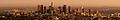
The skyline of Downtown Los Angeles at sunset. The U.S. Bank Tower was once the tallest building on the West Coast.
-
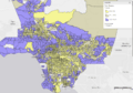
Map showing areas with higher income households in Los Angeles County.
-
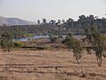
Proctor Valley in Chula Vista.
-
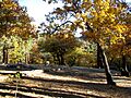
Autumn in the San Gabriel Mountains in Southern California.
-
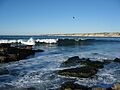
A view from La Jolla Cove in San Diego.
-
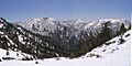
Peaks in the eastern San Gabriel Mountains.
-
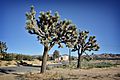
Yucca Valley with a Visitor Center in the background.
-
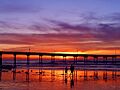
A beautiful sunset at Ocean Beach in San Diego.
-
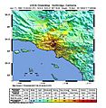
Shake map from the 1994 Northridge earthquake.
-
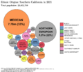
Chart showing ethnic origins in Southern California.


.jpg)


See also
 In Spanish: Sur de California para niños
