
Anza-Borrego Desert State Park facts for kids
Quick facts for kids Anza-Borrego Desert State Park |
|
|---|---|
|
IUCN Category III (Natural Monument)
|
|

Desert view from Font's Point
|
|

Anza-Borrego Desert State Park
Location in California

Anza-Borrego Desert State Park
Location in the United States
|
|
| Location | San Diego, Imperial, and Riverside counties, California, US |
| Nearest city | Borrego Springs and Julian, California |
| Area | 585,930 acres (2,371.2 km2) |
| Established | 1933 |
| Governing body | California Department of Parks and Recreation |
| Designated | 1974 |
Anza-Borrego Desert State Park (pronounced AN-zuh buh-RAY-goh) is a huge California State Park in the Colorado Desert of southern California, United States. The park gets its name from an explorer named Juan Bautista de Anza. The word borrego is Spanish for sheep.
This park covers about 585,930 acres (237,120 hectares). It takes up one-fifth of San Diego County. This makes it the largest state park in California. It is also the third largest state park in the whole country!
The park is mostly in eastern San Diego County. It also reaches into Imperial and Riverside counties. Two towns are inside the park: Borrego Springs, where the park's main office is, and Shelter Valley.
Contents
Exploring the Park's Landscape
.jpg)
Anza-Borrego Desert State Park is a very important part of the Mojave and Colorado Deserts Biosphere Reserve. It is also next to the Santa Rosa and San Jacinto Mountains National Monument.
High mountains surround the park's desert area. The Vallecito Mountains are to the south. The tallest Santa Rosa Mountains are to the north. These northern mountains are a wilderness area. They have no paved roads and are home to the only year-round creeks.
Valleys and Canyons

Blair Valley is a large valley within the State Park. It has a main part and a smaller part called Little Blair Valley. A small mountain range separates them. You can cross this range using Foot and Walker Pass.
To the west of Blair Valley is Granite Mountain. To the east are the Vallecito Mountains. You can drive on dirt roads through the valley. These roads lead to places like a viewpoint over Smuggler Canyon. You can also find sites with ancient Native American art.
Borrego Palm Canyon is where the park's main office is. It offers a famous view of the "Borrego Badlands." These badlands are barren and have been shaped by erosion. Tamarisk Grove has a campground. It is near Yaqui Well, a historic watering spot. This spot has beautiful desert ironwood trees and lots of wildlife.
Visiting Anza-Borrego Desert State Park

Anza-Borrego is often pictured as a wrinkled wasteland of harshly eroded, nearly barren clay and gravel, possibly because its gullied badlands are its most eroded phenomenon. There is more to it than that: cool piney heights, springs and oozing ciénegas, spectacular although brief waves of wild flowers in spring, and native fragrances of pervasive sage, subtle cottonwood, and even more subtle earth.
The park has 500 miles (800 km) of dirt roads. It also has 12 special wilderness areas. There are 110 miles (180 km) of hiking trails. You can get maps and information at the visitor center. The park even has Wi-Fi access.
The park is about a two-hour drive from San Diego. It's also about two hours from Riverside or Irvine. From Palm Springs, it's about a two-hour drive south.
You can reach the park from the east side using County Route S22 and State Route 78. From the west side, use California County Route S2 and State Route 78. Highway SR-79 goes through the high, forested Laguna Mountains. These highways climb from the coast to 2,400 feet (730 m) high. Then they drop 2,000 feet (610 m) into the Borrego Valley. This valley is in the middle of the park. You can also get to the park from the south using the lower part of S2.
A popular hike near the visitor center is to Hellhole Palms. This is a group of California fan palms in Hellhole Canyon. It is close to Maidenhair Falls. The park also has access points to the famous Pacific Crest Trail.
Stargazing is another fun activity at Anza-Borrego. In 2018, the park was named an International Dark Sky Park. This means it's a great place to see the stars because there's very little light pollution.
Ecotourism is very important for Anza-Borrego. During the peak wildflower superbloom season, the number of people in Borrego Springs grows a lot. The town usually has about 3,400 residents. But during a superbloom, it can have around 200,000 tourists!
Plants and Animals


The park's natural areas are mostly part of the Colorado Desert ecosystem. This is a section of the larger Sonoran Desert. The higher northern and eastern parts of the park are in the California montane chaparral and woodlands area. The park is home to about 600 different kinds of native plants.
The park has wide, gently sloping areas called bajadas. It also has dry riverbeds called washes. You can see amazing rock formations and colorful badlands. There are also vast dry landscapes and mountains.
The bajadas mostly have creosote bushes and bur sage. The palo verde tree, cacti, and ocotillo are also common. In the washes, you can find woodlands with plants like smoke tree, velvet mesquite, and catclaw. The park is special because it has elephant trees. These trees are common in Baja California, Mexico. But in the U.S., they are mostly found only in the Anza-Borrego area.
The park has natural springs and oases. Here you can find the state's only native palm tree, the California fan palm. When there's enough rain, you can see amazing seasonal wildflower displays. These huge blooms, called superblooms, are a big draw for the park. They also show how climate change is affecting the desert. Superblooms are important for the desert's health. They also help the local economy by bringing in many tourists.
The higher areas to the north and east have closed-cone pine forests. You can also find manzanitas and oak woodlands there.
The oases are full of many kinds of animals. They are great for bird-watching. Throughout the park, you might see bighorn sheep, mountain lions, badgers, kit foxes, mule deer, coyotes, greater roadrunners, golden eagles, black-tailed jackrabbits, ground squirrels, kangaroo rats, deer mice, quail, and prairie falcons. Among reptiles, you might spot desert iguanas, chuckwallas, and red diamond rattlesnakes.
Anza-Borrego Desert State Park is home to several endangered species. Sadly, roads and highways can harm these animals. Many animals are hit by cars. Roads also split up natural areas, which makes it harder for animals to move around.
Desert Bighorn Sheep
Some parts of the park are home to the desert bighorn sheep. The peninsula bighorn sheep live in Anza-Borrego. They have been an endangered species since 1998. They are one of the most well-known animals in this state park. Experts count these sheep to study their numbers. They also watch how human activity is causing their population to shrink.
The two biggest threats to bighorn sheep are humans and climate change. As people build more in and around Anza-Borrego Desert State Park, the bighorn sheep lose their homes. Also, hotter temperatures and less rain mean less water for them to drink. Bighorn sheep lose their habitat because of human actions. These include changing water flow, noise, and breaking up their living areas. These sheep are a key part of the desert's ecosystem. So, it's important to protect them and reduce our impact on their special home.
Climate and Its Effects
Anza-Borrego State Park is in the Colorado Desert Region of Southern California. This area is part of the Mexican Sonoran Desert. The climate here is hot and dry. There is not much rain because of the very dry, warm air.
Climate change might bring more wet years, which cause "superblooms." These blooms bring many tourists in winter and early spring. Local towns rely on this tourism to help their economies. However, climate change can also cause longer droughts. These droughts threaten the towns that depend on tourists.
As the environment changes, some people try to keep tourism steady. They might build large resorts or artificial oases. But studies show that plants in artificial oases are not good at handling dry conditions. They also use a lot of groundwater. This lowers the water level underground. It also harms native plants that are used to the desert. Desert animals and plants depend on each other. So, building in deserts or creating artificial oases can harm the whole ecosystem.
| Climate data for Borrego Desert Park, CA | |||||||||||||
|---|---|---|---|---|---|---|---|---|---|---|---|---|---|
| Month | Jan | Feb | Mar | Apr | May | Jun | Jul | Aug | Sep | Oct | Nov | Dec | Year |
| Record high °F (°C) | 90 (32) |
95 (35) |
101 (38) |
111 (44) |
114 (46) |
122 (50) |
121 (49) |
120 (49) |
117 (47) |
113 (45) |
98 (37) |
87 (31) |
122 (50) |
| Mean daily maximum °F (°C) | 69.3 (20.7) |
72.3 (22.4) |
77.9 (25.5) |
84.5 (29.2) |
93.2 (34.0) |
102.7 (39.3) |
107.4 (41.9) |
106.1 (41.2) |
101.0 (38.3) |
89.7 (32.1) |
77.9 (25.5) |
68.9 (20.5) |
87.6 (30.9) |
| Mean daily minimum °F (°C) | 44.0 (6.7) |
46.5 (8.1) |
50.0 (10.0) |
53.8 (12.1) |
60.7 (15.9) |
68.4 (20.2) |
75.8 (24.3) |
75.5 (24.2) |
70.3 (21.3) |
60.6 (15.9) |
50.4 (10.2) |
43.4 (6.3) |
58.3 (14.6) |
| Record low °F (°C) | 20 (−7) |
24 (−4) |
28 (−2) |
28 (−2) |
34 (1) |
45 (7) |
56 (13) |
55 (13) |
49 (9) |
33 (1) |
31 (−1) |
23 (−5) |
20 (−7) |
| Average precipitation inches (mm) | 1.11 (28) |
1.08 (27) |
0.70 (18) |
0.23 (5.8) |
0.06 (1.5) |
0.02 (0.51) |
0.28 (7.1) |
0.51 (13) |
0.30 (7.6) |
0.30 (7.6) |
0.45 (11) |
0.80 (20) |
5.84 (147.11) |
| Average snowfall inches (cm) | 0 (0) |
0 (0) |
0 (0) |
0 (0) |
0 (0) |
0 (0) |
0 (0) |
0 (0) |
0 (0) |
0 (0) |
0 (0) |
0.1 (0.25) |
0.1 (0.25) |
| Source: http://www.wrcc.dri.edu/cgi-bin/cliMAIN.pl?ca0983 | |||||||||||||
Ancient History: Fossils and Geology

The eroded badlands of Anza-Borrego Desert State Park offer a look into the region's ancient past. This area was not always a desert. Paleontology, the study of fossils, helps us understand this prehistoric world. The park has an amazing collection of fossils. These include ancient plants, shells, animal tracks, and bones. Most fossils found here are from six million to about half a million years ago. This was long after the last dinosaurs disappeared.
How the Land Was Formed


Anza-Borrego Desert State Park is in a special spot. It sits along the western edge of the Salton Trough. This is a huge dip in the land. It is the northern end of an active rift valley. This valley is where two of Earth's tectonic plates meet. The trough stretches from the Gulf of California north to San Gorgonio Pass. It goes from the eastern edge of the Peninsular Ranges to the San Andreas Fault zone.
Over the last seven million years, more than 20,000 feet (6,100 m) of sediment has built up here. This sediment contains many fossils. Fossils are found over hundreds of square miles of eroded badlands. These areas stretch from the Santa Rosa Mountains south into northern Baja California, Mexico.
The fossils show both ocean and land environments. Six million years ago, the ancient Gulf of California covered the Salton Trough. It reached north past where Palm Springs is today. These warm waters were home to many sea creatures. Over time, the sea began to disappear. This happened as a huge amount of sediment from the forming Grand Canyon flowed into the Salton Trough. Slowly, the ancient Colorado River built a massive river delta across the seaway. Fossils of hardwood trees from this delta show that the area once received three times more rain than it does now.
The Anza-Borrego region slowly changed from mostly ocean to a system of land habitats. North of the Colorado River Delta, a series of lakes and dry lakes existed for over three million years. At the same time, sediment from the growing Santa Rosa Mountains and other Peninsular Ranges spread east. These sediments provide a nearly complete fossil record of land animals. This record ends about half a million years ago. Here, ancient streams and rivers trapped the remains of animals. These animals lived in a vast brushland savannah with woodlands along the rivers.
Amazing Fossils Found Here
This record of changing environments includes over 550 types of fossil plants and animals. These range from tiny plant pollen to baleen whale bones and mammoth skeletons. Many of these species are now extinct. Some are only known from fossils found in this park. This wide variety of fossils, along with the long history of sediment layers, makes this park an incredibly important place for paleontology worldwide.
The fossils here show important changes in Earth's history. These changes mark the beginning of the Ice Ages. The layers of rock contain clues about how modern southwestern desert landscapes formed.
The first fossils were collected in 1853 by William Blake. He found marine shells from the ancient Gulf of California. He also found freshwater shells from a prehistoric lake called Lake Cahuilla. This lake was the ancestor of today's Salton Sea. Blake was a geologist who was looking for a railway route to the Pacific. He was the first to call this region the Colorado Desert.
Life in the Ancient Ocean

Since the late 1800s, many studies have focused on the sea creatures that lived in the ancient Gulf of California. Fossils from the Imperial Formation include tiny plant plankton and dinoflagellates. There are also foraminifera, corals, polychaetes, clams, snails, sea urchins, sand dollars, crabs, and shrimp. The deposits also have bones of sea animals. These include sharks and rays, bony fish, baleen whales, walruses, and dugongs.
The Imperial Formation shows different ocean environments. These include outer and inner shelves, reefs, beaches, and lagoons. As the sea became shallower, it became more like an estuary or brackish water. This is shown by thick layers of oyster and pecten shells. These now form the "Elephant Knees" along Fish Creek. Many of the marine fossils are similar to those found in the Caribbean Sea. This shows a time before the Isthmus of Panama formed. Back then, the warm Gulf Stream from the western Atlantic Ocean flowed into the eastern Pacific Ocean.
Life on Ancient Land
When North and South America connected about three million years ago, animals started moving between the continents. This is called the Great American Interchange. Evidence of this is found in Anza-Borrego's fossils. Animals like giant ground sloths and porcupines first appeared in North America at this time.
The oldest land animal fossils from the Colorado Desert are even older. These very rare fossils are from 10 to 12 million years ago. They include an elephant-like mammal called a gomphothere, a rodent, a cat, and a small camelid. These were found in ancient river and lake deposits.
However, the most important and common land animal fossils are from later times. They are from the latest Miocene through late-Pleistocene periods. These were found in river and flood plain deposits. These fossils are in a 3.5-million-year-long, unbroken sequence of rock layers. Scientists have dated these layers using volcanic ash and magnetic methods.
The animals that lived in this ancient savannah included some very unusual creatures. Some of them were:
- Geochelone, a giant tortoise the size of a bathtub.
- Aiolornis incredibilis, the largest flying bird in the Northern Hemisphere, with a 17-foot (5.2-meter) wingspan.
- Paramylodon, Megalonyx, and Nothrotheriops, giant ground sloths. Some even had bony armor in their skin!
- Pewelagus, a very tiny rabbit.
- Borophagus, a hyena-like dog.
- Arctodus, a giant short-faced bear.
- Smilodon, a saber-toothed cat.
- Miracinonyx, the North American cheetah.
- Mammuthus imperator, the largest known mammoth.
- Tapirus, an extinct tapir.
- Equus enormis and Equus scotti, two types of extinct horses.
- Gigantocamelus, a giant camel.
- Capromeryx minor, the dwarf pronghorn.
Inside the park, mammoth remains have been found at 46 different sites. These include two complete skulls and part of a skeleton. Most of these sites are in the Borrego Badlands. Different types of mammoth fossils have been found here, such as Gompotherium, Stegomastodon, Mammuthus meridionalis, and Mammuthus columbi. A Gompotherium jaw is on display at the University of California Museum of Paleontology in Berkeley.
Native American History

The Native Americans who lived in the surrounding mountains and deserts included the Cahuilla, Cupeño, and Kumeyaay tribes. This land was their home for thousands of years. Their artists created petroglyphs (carvings) and pictograms (paintings) on rocks. These artworks show their cultures.
They ate foods like the Agave deserti plant, jumping cholla cactus, jackrabbit, bighorn sheep, and Indian rice grasses. Preparing and gathering food took a lot of work and time. Roasting pits, grinding holes in rocks, and other tools show this. Many artifacts have been found, such as obsidian (volcanic glass), pumice (lightweight volcanic rock), and fish bones. These tell us that these groups traded a lot with each other across the region. These findings were made at a site called CA-SDI-813, also known as the Mine Wash Site, in Anza-Borrego Desert State Park.
Park Organizations
The Anza-Borrego Foundation was started in 1967. It is a non-profit group that helps the park. It is the only official partner of the park. This foundation manages all sales at the State Park Visitor Center and the State Park Store.
The Anza-Borrego Institute is the education part of the foundation. It offers in-depth learning programs to over 100,000 visitors each year. The institute has field programs, a special camp for fifth graders, and citizen science research. It also helps teachers and students with online resources. The foundation's main goal is to protect the park's natural beauty, wildlife, and cultural history. They want to make sure it can be enjoyed by people now and in the future.
Gallery
- Flora and fauna of Anza-Borrego Desert Park
-
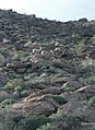
Peninsular bighorn sheep in Anza-Borrego Desert State Park
-
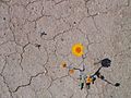
A desert marigold pushes its way through the dry, cracked, and sun-hardened desert after a rare and substantial rainfall
-
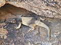
Common chuckwalla, Sauromalus ater in Palm Canyon, near Palm Springs
-
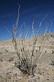
An ocotillo plant common in Anza-Borrego Desert State Park


See also
 In Spanish: Parque Estatal Desierto de Anza-Borrego para niños
