
Riverside County, California facts for kids
Quick facts for kids
Riverside County
|
|||
|---|---|---|---|
| County of Riverside | |||
    .jpg)   Images, from top down, left to right: Riverside's Mission Inn Festival of Lights, North face of the San Jacinto Mountains in the Santa Rosa and San Jacinto Mountains National Monument, Coachella Valley Music and Arts Festival, Temecula Valley Balloon and Wine Festival, Palm Springs aerial tramway, Joshua Tree National Park, Riverside National Cemetery Medal of Honor memorial
|
|||
|
|||

Location in the state of California
|
|||
| Country | United States | ||
| State | California | ||
| Region | Inland Empire | ||
| Incorporated | May 9, 1893 | ||
| Named for | The City of Riverside, and the city's location beside the Santa Ana River | ||
| County seat | Riverside | ||
| Largest city (population) | Riverside | ||
| Largest city (area) | Palm Springs | ||
| Government | |||
| • Type | Council–CEO | ||
| Area | |||
| • Total | 7,303 sq mi (18,910 km2) | ||
| • Land | 7,206 sq mi (18,660 km2) | ||
| • Water | 97 sq mi (250 km2) | ||
| Highest elevation | 10,843 ft (3,305 m) | ||
| Lowest elevation | −234 ft (−71.3 m) | ||
| Population
(2020)
|
|||
| • Total | 2,418,185 | ||
| • Density | 336/sq mi (130/km2) | ||
| GDP | |||
| • Total | $95.159 billion (2022) | ||
| Time zone | UTC−8 (Pacific Time Zone) | ||
| • Summer (DST) | UTC−7 (Pacific Daylight Time) | ||
| FIPS code | 06-065 | ||
| Congressional districts | 25th, 35th, 39th, 40th, 41st, 48th | ||


Riverside County is a large county in Southern California. As of 2020, over 2.4 million people live here. This makes it the fourth-most populated county in California and the 10th-most populated in the whole United States. The county is named after the city of Riverside, which is its main city and where the county government is located.
Riverside County is part of a larger area called the Inland Empire. This area also includes San Bernardino and Ontario. The county stretches from the greater Los Angeles area all the way to the Arizona border.
The western part of the county has a mild, Mediterranean climate with lots of chaparral plants. But as you move east, the land becomes mostly desert or mountains. A big part of Joshua Tree National Park is in Riverside County. Many popular resort cities like Palm Springs, Indio, and Coachella are found in the desert area called the Coachella Valley.
Many people have moved to Riverside County from the Los Angeles metropolitan area and San Diego metropolitan area. They come for more affordable homes. Cities like Temecula and Murrieta have grown a lot because of this.
Contents
- Where is Riverside County?
- How did Riverside County get its name?
- A Look Back: History of Riverside County
- What is Riverside County like?
- People of Riverside County
- Learning and Education
- Getting Around: Transportation
- Fun Places to Visit
- Communities in Riverside County
- Climate
- Images for kids
- See also
Where is Riverside County?
Riverside County shares its borders with several other counties and a state.
- To the north is San Bernardino County.
- To the northeast is La Paz County in Arizona.
- To the southeast is Imperial County.
- To the southwest is San Diego County.
- To the west is Orange County.
- To the northwest is Los Angeles County.
How did Riverside County get its name?
When Riverside County was created in 1893, it was named after its main city, Riverside. The city of Riverside was founded in 1870. It got its name because it is located near the Santa Ana River.
A Look Back: History of Riverside County
Early People of the Land

Long before Europeans arrived, different groups of Native American people lived in the valleys, mountains, and deserts of what is now Riverside County. These groups included the Serrano, Payómkawichum, Mohave, Cupeno, Chemehuevi, Cahuilla, and Tongva tribes. For example, the Cahuilla people traditionally lived in the inland valleys of the Santa Rosa and San Jacinto Mountains, and the desert around the Salton Sink.
Spanish and Mexican Times
The first European settlement in the area was a farm called an estancia at the Luiseño village of Temescal. This farm belonged to the Mission San Luis Rey de Francia. In 1819, a man named Leandro Serrano was allowed to use the land for farming and raising animals. He started Rancho Temescal.
Later, in 1821, Mexico became independent from Spain. The San Gabriel Mission continued to grow and started Rancho San Gorgonio in 1824. This ranch was one of the Mission's most important and farthest outposts. It covered most of the San Gorgonio Pass area today. After Mexico took over the mission lands in 1833, many large ranches were created across the state, including several in what is now Riverside County.
Becoming Part of the United States
When California first became a state in 1850, the area that is now Riverside County was split between Los Angeles County and San Diego County. In 1853, San Bernardino County was created from the eastern part of Los Angeles County.
How Riverside County Was Formed
Between 1891 and 1893, people tried to create new counties in Southern California. Finally, a plan to create Riverside County was approved on March 11, 1893. The new county was made from parts of San Bernardino County and San Diego County. On May 2, 1893, most voters agreed to form Riverside County and chose the city of Riverside as the county seat. Riverside County officially began on May 9, 1893.
The county is also home to the March Air Reserve Base. This is one of the oldest airfields used by the United States military. It started in 1918 as a training field during World War I. It was renamed March Field and became a very important base during World War II and the Cold War. Today, it is a major base for the Air Force Reserve.
Riverside County was also important during the Civil Rights Movement. Many people, including Cesar Chavez who fought for farm workers' rights, visited the area.
Native American tribes in Riverside County have also been a focus of modern gaming businesses. In the 1980s, the county tried to stop small bingo games run by the Morongo Band of Cahuilla Mission Indians and the Cabazon Band of Mission Indians. The tribes worked together and won their case in the U.S. Supreme Court in 1987. This led to a law in 1988 that set up rules for Native American gaming and state governments. Now, both tribes run large casinos in the county.
The county's population grew very quickly starting in the 1970s. By 1990, over a million people lived here. At first, many people moved here to live and commute to jobs in Los Angeles or Orange County. But since the late 1990s, Riverside County has also become a place where new businesses, offices, and factories are built, creating many local jobs.
What is Riverside County like?
_04.jpg)
Riverside County is very large, covering about 7,206 square miles. It is the fourth-largest county in California. It is about 180 miles wide from east to west, which is roughly the size of the entire state of New Jersey! Driving from the county seat in Riverside to the town of Blythe near the Colorado River can take about three hours.
The county has different types of land. The western part is often called the Inland Empire. The eastern part is mostly Mojave Desert or Colorado Desert. There are also mountains like the Santa Rosa Mountains and areas around the Salton Sea.
Plants and Animals in Riverside County


Riverside County has many different kinds of plants and animals. You can find many desert plants, but there are also forests. The Blue oak tree, which is native to California, grows in Riverside County at the southern end of its natural range.
Protected Natural Areas
Many parts of Riverside County are protected to preserve their natural beauty and wildlife. These include:
- Cleveland National Forest (part)
- Joshua Tree National Park (part)
- San Bernardino National Forest (part)
- Sand to Snow National Monument (part)
- Santa Rosa and San Jacinto Mountains National Monument
There are also 19 official wilderness areas in Riverside County. These are special places where nature is kept wild and untouched.
State and County Parks
- California Citrus State Historic Park
- Lake Perris State Recreation Area
- Mount San Jacinto State Park
- Hurkey Creek Park
- Idyllwild Park
- Lake Skinner Recreation Area
- Santa Rosa Plateau
People of Riverside County
| Historical population | |||
|---|---|---|---|
| Census | Pop. | %± | |
| 1900 | 17,897 | — | |
| 1910 | 34,696 | 93.9% | |
| 1920 | 50,297 | 45.0% | |
| 1930 | 81,024 | 61.1% | |
| 1940 | 105,524 | 30.2% | |
| 1950 | 170,046 | 61.1% | |
| 1960 | 306,191 | 80.1% | |
| 1970 | 459,074 | 49.9% | |
| 1980 | 663,166 | 44.5% | |
| 1990 | 1,170,413 | 76.5% | |
| 2000 | 1,545,387 | 32.0% | |
| 2010 | 2,189,641 | 41.7% | |
| 2020 | 2,418,185 | 10.4% | |
| 2023 (est.) | 2,492,442 | 13.8% | |
| U.S. Decennial Census 1790–1960 |
|||
Population in 2020

In 2020, Riverside County had a population of 2,418,185 people. The county is very diverse. About 32.6% of the people were White (not Hispanic). About 6.07% were Black or African American. About 6.82% were Asian. And about 49.72% of the population was Hispanic or Latino, who can be of any race. This shows how many different cultures and backgrounds make up Riverside County.
Learning and Education
Colleges and Universities

Riverside County has many colleges and universities where students can continue their education after high school. Some of these include:
- California Baptist University in Riverside
- California State University, San Bernardino, which has a campus in Palm Desert
- College of the Desert in Palm Desert and Indio
- La Sierra University in Riverside
- Mt. San Jacinto College with campuses in Banning, Menifee, San Jacinto, and Temecula
- Riverside City College
- University of California, Riverside
K-12 Schools
Riverside County has many public school districts that serve students from kindergarten through 12th grade. These districts include:
- Alvord Unified School District
- Corona-Norco Unified School District
- Desert Sands Unified School District
- Hemet Unified School District
- Jurupa Unified School District
- Lake Elsinore Unified School District
- Moreno Valley Unified School District
- Murrieta Valley Unified School District
- Palm Springs Unified School District
- Riverside Unified School District
- Temecula Valley Unified School District
There are also special schools like the California School for the Deaf, Riverside and Sherman Indian High School.
Getting Around: Transportation
Main Roads
Many important highways run through Riverside County, connecting its cities and towns.
 I-10
I-10 I-15
I-15 I-215
I-215 U.S. Route 95
 State Route 60
 State Route 74
 State Route 91
 State Route 111
Public Transport
- Buses: The Riverside Transit Agency serves the western part of the county. The SunLine Transit Agency serves the Palm Springs and Coachella Valley areas. Other agencies serve smaller communities.
- Trains: Amtrak trains stop in Riverside and Palm Springs. Metrolink commuter trains serve nine stations in Riverside County. These trains connect to Orange, San Bernardino, and Los Angeles counties.
Airports
Riverside County has several airports, including:
- Palm Springs International Airport for commercial flights.
- March Air Reserve Base, a military air base.
- Many smaller airports for general aviation, like Riverside Municipal Airport and French Valley Airport.
Fun Places to Visit
Riverside County has many interesting places to explore:
- The Cheech Marin Center for Chicano Art & Culture: A museum dedicated to Chicano art.
- Empire Polo Club: Home to famous music festivals like Coachella and Stagecoach.
- Joshua Tree National Park: A beautiful desert park with unique trees and rock formations.
- Living Desert Zoo and Gardens: A zoo and botanical garden focusing on desert animals and plants.
- March Field Air Museum: A museum dedicated to aviation history at the March Air Reserve Base.
- Mission Inn Hotel & Spa: A historic and beautiful hotel in Riverside.
- Palm Springs Aerial Tramway: A tramway that takes you up to Mount San Jacinto State Park for amazing views.
- Riverside National Cemetery: A national cemetery with a special memorial for Medal of Honor recipients.
- Santa Rosa Plateau: A natural preserve with unique habitats and trails.
- Temecula Valley AVA Wine Region: An area known for its vineyards and wineries.
- Western Science Center: A museum focused on natural history and science.
Communities in Riverside County
Cities
Riverside County has many cities, each with its own unique character. Here are some of the largest:
| City | Population, 2020 |
|---|---|
| † Riverside | 314,998 |
| Moreno Valley | 208,634 |
| Corona | 157,136 |
| Murrieta | 110,949 |
| Temecula | 110,003 |
| Jurupa Valley | 105,053 |
| Menifee | 102,527 |
| Hemet | 89,833 |
| Indio | 89,137 |
| Perris | 78,700 |
| Lake Elsinore | 70,265 |
| Eastvale | 69,757 |
| San Jacinto | 53,898 |
| Beaumont | 53,036 |
| Cathedral City | 51,493 |
| Palm Desert | 51,163 |
| Palm Springs | 44,575 |
| Coachella | 41,941 |
| La Quinta | 37,558 |
| Wildomar | 36,875 |
Unincorporated Communities
These are smaller towns and areas that are not officially cities but are still important parts of Riverside County.
Native American Reservations
Riverside County is home to 12 federally recognized Indian reservations. This is one of the highest numbers for any county in the United States. These reservations are sovereign lands belonging to Native American tribes.
- Agua Caliente Indian Reservation
- Augustine Indian Reservation
- Cabazon Indian Reservation
- Cahuilla Indian Reservation
- Colorado River Indian Reservation (partly in La Paz County, Arizona and San Bernardino County, California)
- Morongo Indian Reservation
- Pechanga Indian Reservation
- Ramona Village
- Santa Rosa Indian Reservation
- Soboba Band of Mission Indians
- Torres-Martinez Indian Reservation (partly in Imperial County, California)
- Twenty-Nine Palms Indian Reservation (partly in San Bernardino County, California)
Climate
|
||||||||||||||||||||||||||||||||||||||||||||||||||||||||||||||||||||||||||||||||||||||||||||||||
Riverside County has a varied climate due to its large size and different landscapes. The western parts have a Mediterranean climate with warm, dry summers and mild, wet winters. As you move east into the desert areas, the climate becomes much hotter and drier, especially in summer. Winters in the desert are mild. The mountains have cooler temperatures and more snow in winter.
Images for kids
-
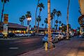
El Paseo in Palm Desert, California
-
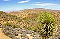
Yucca pines near Ryan Mountain Trail in Joshua Tree National Park
-
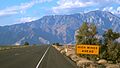
Southerly view of the San Jacinto Mountains from State Route 62
See also
 In Spanish: Condado de Riverside para niños
