
Santa Ana River facts for kids
Quick facts for kids Santa Ana River |
|
|---|---|

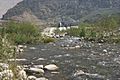
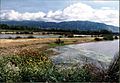
The Santa Ana River as seen from a small bluff overlooking the water.
|
|

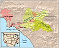
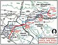
Map of the Santa Ana River drainage basin
|
|
| Other name(s) | Rio de los Temblores, Rio de Santa Anna |
| Country | United States |
| State | California |
| Counties | San Bernardino, Riverside, Los Angeles, Orange |
| Cities | San Bernardino, Riverside, Anaheim, Santa Ana |
| Physical characteristics | |
| Main source | Coon Creek 8,650 ft (2,640 m) 34°09′14″N 116°41′20″W / 34.15389°N 116.68889°W |
| 2nd source | Heart Bar Creek 7,900 ft (2,400 m) 34°08′06″N 116°44′23″W / 34.13500°N 116.73972°W |
| River mouth | Pacific Ocean Huntington Beach, Orange County 0 ft (0 m) 33°37′41″N 117°57′31″W / 33.62806°N 117.95861°W |
| Length | 96 mi (154 km), Northeast-Southwest |
| Basin features | |
| Basin size | 2,650 sq mi (6,900 km2) |
| Tributaries | |
The Santa Ana River is a big river in southern California, in the United States. It starts high up in the San Bernardino Mountains in San Bernardino County. From there, it flows west for about 100 miles (160 km) (160 km) until it reaches the Pacific Ocean.
This river travels through several counties, including Riverside and Orange counties. It has a large watershed, which is the area of land where all the rain and snowmelt drain into the river. This watershed covers about 2,650 square miles (6,863 square kilometers).
The Santa Ana River has many smaller streams that flow into it, called tributaries. Some of its biggest tributaries are Lytle Creek, Temescal Creek, and Santiago Creek. Just like other rivers in the area, like the Los Angeles River, parts of the Santa Ana River are lined with concrete. This helps control the water flow. A very important structure on the river is the Seven Oaks Dam. It's 632 feet (193 m) tall, making it one of the tallest dams in the United States!
Contents
Where the River Begins and Ends
Starting High in the Mountains
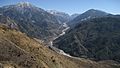
The Santa Ana River begins in the beautiful San Bernardino Mountains. It's formed by two smaller streams, Coon Creek and Heart Bar Creek, coming together. This meeting point is high up, about 6,991 feet (2,131 meters) above sea level. Imagine starting your journey from such a high place!
Journey to the Ocean
From the mountains, the river flows through many different areas. It passes through cities like San Bernardino, Riverside, Anaheim, and Santa Ana. As it gets closer to the coast, the river often flows through channels made of concrete.
Reaching the Pacific Ocean
Finally, after its long journey, the Santa Ana River empties into the Pacific Ocean. This happens near Huntington Beach in Orange County. At this point, the river is at sea level, meaning it's 0 feet (0 meters) high.
Why the Santa Ana River is Important
Controlling Floods
The Santa Ana River has a history of big floods, especially before dams and channels were built. For example, in 1938, a huge flood caused a lot of damage. To prevent this, engineers built dams like the Seven Oaks Dam and the Prado Dam. They also lined parts of the river with concrete. These projects help control the water, especially during heavy rains, keeping nearby communities safe.
Water for People
Even though parts of the river can look dry, the Santa Ana River is a very important source of water for the millions of people who live in Southern California. Water from the river and its underground sources (called aquifers) is treated and used for drinking, farming, and other needs.
Fun and Nature
The river isn't just for water and flood control. Many parts of the Santa Ana River have riparian zones, which are areas with plants and animals that live near the water. These areas are important for wildlife. There's also a long bicycle path along the river, which is great for biking, walking, and enjoying nature.
Images for kids
-
Map Santa Ana River
-
Mill Creek (pictured) is one of the main headwaters tributaries of the Santa Ana River.
-
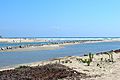
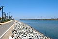
The channeled mouth of the Santa Ana River between Huntington Beach and Newport Beach
-
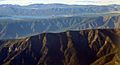
The Transverse Ranges were formed by uplift along the San Andreas Fault. Santa Ana Canyon is between the first and second ridges and Big Bear Lake is in the background.
-
This segment of the Santa Ana River just downstream of Seven Oaks Dam marks the beginning of the inland riparian zone
-
Bernardo Yorba Adobe was built by Mexican settlers in Rancho Cañón de Santa Ana in 1835
-
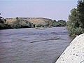
The Santa Ana River near Riverside
-
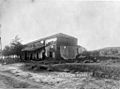
The Santa Ana River flooding in 1938, just downstream of Santa Ana Canyon. This view, taken by a Los Angeles Times photographer from a United Air Lines "Mainliner", shows flooded agricultural fields in central Orange County, with the Pacific Ocean in the distance.
-
Army Corps of Engineers map of the 100-year floodplain of the Santa Ana River
-
The Prado Flood Control Basin on the Santa Ana River has one of the largest remaining riparian zones along the main stem.
-
The Santa Ana River bicycle path
-
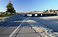
The Orangewood Avenue bridge near Angel Stadium of Anaheim


.JPG)
See also
 In Spanish: Río Santa Ana para niños
