
San Timoteo Creek facts for kids
Quick facts for kids San Timoteo Creek |
|
|---|---|

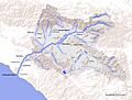
Map of the Santa Ana River drainage basin
|
|
| Other name(s) | San Timoteo Wash |
| Country | United States |
| State | California |
| Counties | San Bernardino, Riverside |
| Physical characteristics | |
| Main source | Confluence of Little San Antonio Creek and Noble Creek San Bernardino Mountains 2,430 ft (740 m) 33°56′28″N 117°0′22″W / 33.94111°N 117.00611°W |
| River mouth | Santa Ana River Near Loma Linda 1,004 ft (306 m) 34°04′10″N 117°16′50″W / 34.06944°N 117.28056°W |
| Basin features | |
| Basin size | 125 sq mi (320 km2) |
| Tributaries |
|
San Timoteo Creek is a stream in southern California, United States. It is also known as San Timoteo Wash or simply San Tim. This creek flows through Riverside and San Bernardino counties.
San Timoteo Creek is a smaller stream that flows into the Santa Ana River. It runs through a place called San Timoteo Canyon. The area of land that drains water into the creek is about 125 square miles (320 km2). Most of its water comes from smaller streams in the San Bernardino Mountains, near Cherry Valley. Another important stream, Yucaipa Creek, also adds water to San Timoteo Creek.
In the past, the creek would sometimes dry up. But today, it flows all year. This is because of water from farms and treated water from a plant in Yucaipa. The name "San Timoteo" was given to the creek and canyon around 1830. It means Saint Timothy in Spanish.
Contents
Where San Timoteo Creek Flows
San Timoteo Creek starts when two smaller streams, Little San Antonio Creek and Noble Creek, join together. This happens west of Beaumont. Another stream, Coopers Creek, joins it just before San Timoteo Creek enters San Timoteo Canyon.
The creek then flows northwest through San Timoteo Canyon. This area is north of a place called The Badlands, which are in the southern hills of Redlands. Inside the canyon, Yucaipa Creek also flows into San Timoteo Creek. After leaving the canyon, the creek passes through Bryn Mawr and Loma Linda. Finally, it reaches its end at the Santa Ana River. This spot is near where two major highways, I-10 and I-215, meet.
History of the Creek and Canyon
San Timoteo Canyon has a long history. Native Americans and Spanish ranchers used it as a path for travel. Later, from the 1880s to the 1920s, stagecoaches used San Timoteo Canyon Road. By the 1910s, cars also started using this road.
A large village of Native Americans once stood near the entrance to San Timoteo Canyon. The people from this village later became part of the Mission San Gabriel Arcángel. In the 1800s, a new village called Saahatpa was built in the canyon. It was founded by Chief Juan Antonio and his group of Cahuilla Indians. Sadly, the village was left empty after a terrible smallpox sickness in 1862–63.
In May 1877, the Southern Pacific Railroad Company built train tracks through San Timoteo Canyon. These tracks went over San Gorgonio Pass and continued east to Yuma, Arizona.
Floods and Flood Control Efforts
San Timoteo Creek has flooded several times in history. During the big Los Angeles flood of 1938, the creek overflowed and caused a lot of damage. In 1969, the creek flooded again. It damaged parts of Redlands and covered two-thirds of Loma Linda with water. Many bridges over the creek were washed away, and Loma Linda Academy was completely flooded.
These floods led to discussions about how to control the creek's water. In 1988, the government planned to build channels along the whole creek to control floods. However, many local people did not want this. They worried it would harm the natural environment.
Eventually, a plan was agreed upon. In 2008, the US Army Corps of Engineers only partly built channels along the creek. In 2010, parts of Loma Linda flooded again. In 2013, the Corps of Engineers finished a project to help control floods. This included keeping the creek clean and replanting plants along its banks.
Today, the creek is a popular place for hiking and mountain biking.
Protecting the Creek's Environment
More and more buildings are being built in the area around San Timoteo Creek. This means there is a higher chance of floods. The United States Army Corps of Engineers has built structures to control floods along most of the lower parts of the creek. A concrete channel runs for about 3.1 mi (5.0 km) from where the creek meets the Santa Ana River.
Further upstream, people did not want more concrete channels. So, the flood control in those areas uses a natural, soft-bottom channel. The Environmental Protection Agency is working with local groups to restore parts of the creek's natural environment. They want to make it as close to its original state as possible.
San Timoteo Creek is very important for wildlife. It is one of the few remaining natural paths for animals to move between the Santa Ana River and the mountains. It is also one of the last major streams in this part of Southern California that still has important natural plants and animal homes along its banks.
Images for kids
-
Map of the Santa Ana River drainage basin
