Yucaipa, California facts for kids
Quick facts for kids
Yucaipa, California
|
||
|---|---|---|

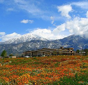
Yucaipa City Hall, with San Bernardino Peak in the background
|
||
|
||

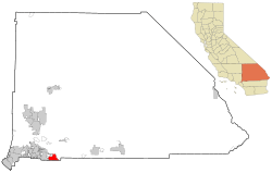
Location in San Bernardino County and the state of California
|
||
| Country | United States | |
| State | California | |
| County | San Bernardino | |
| Incorporated | November 27, 1989 | |
| Government | ||
| • Type | Council-Manager | |
| Area | ||
| • Total | 28.27 sq mi (73.22 km2) | |
| • Land | 28.27 sq mi (73.22 km2) | |
| • Water | 0.00 sq mi (0.00 km2) 0.02% | |
| Elevation | 2,618 ft (798 m) | |
| Population
(2020)
|
||
| • Total | 54,542 | |
| • Density | 1,929.32/sq mi (744.91/km2) | |
| Time zone | UTC-8 (PST) | |
| • Summer (DST) | UTC-7 (PDT) | |
| ZIP code |
92399
|
|
| Area code(s) | 909 | |
| FIPS code | 06-87042 | |
| GNIS feature ID | 1652818 | |
Yucaipa is a city in San Bernardino County, California. It is about 10 miles (16 km) east of San Bernardino. In 2020, about 54,542 people lived there. Yucaipa has been home to many Serrano Native Americans for a long time.
Contents
History of Yucaipa
Before people from Europe and Mexico arrived, the Yucaipa Valley was called Yukaipa't. This meant "green valley" in the Serrano language. The Serrano Native Americans lived here for thousands of years. Today, some of their family members are part of the San Manuel Band of Mission Indians.
Yucaipa Rancheria
| Yucaipa Rancheria | |
|---|---|
| Location | Yucaipa, California |
| Built | 1842 |
| Designated | September 11, 1957 |
| Reference no. | 620 |
The Yucaipa Valley was home to many Serrano Native Americans. Fresh water from springs and creeks flowed from the San Bernardino Mountains. The Serrano people lived in this area for most of the year. They would also go into the mountains to gather acorns and other foods. This important historical site is marked by California Historical Landmark #620.
The Yucaipa Adobe
| Yucaipa Adobe | |
|---|---|
| Location | Yucaipa, California |
| Built | 1842 |
| Designated | September 11, 1957 |
| Reference no. | 528 |
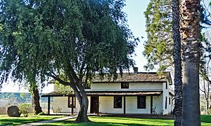
Close to the Rancheria is the Yucaipa Adobe. Many believe it is the oldest house in San Bernardino County. Diego Sepúlveda built the Adobe in 1842. It was part of the Rancho San Bernardino, a large piece of land. The Rancho was later sold to Mormon settlers in 1851. The Adobe has had several owners over the years. San Bernardino County bought it in 1955. This site is marked by California Historical Landmark #528.
The nearby Oak Glen area is famous for its apple orchards. Some of these orchards are still run by the families who first started them.
Yucaipa in the 21st Century
On June 16, 2005, Yucaipa had an earthquake. It was a 4.9 magnitude earthquake. It was felt in Los Angeles and San Diego.
In 2016, Yucaipa started building a new performing arts center. This center opened in 2019. It hosts many events like plays, concerts, and dance shows.
Geography and Parks
Yucaipa is in southern California. It is about 72 miles (116 km) east of Los Angeles. The city is about 2,600 feet (792 m) above sea level. It is next to Redlands to the west and Calimesa to the south.
The city has a total area of about 27.8 square miles (72 km2). Very little of this area is water.
Parks in Yucaipa
Yucaipa has many parks for everyone to enjoy. These include:
- Yucaipa Regional Park
- Flag Hill Veterans Memorial Park
- Seventh Street Park
- "I" Street Park
- Wildwood Park
- Yucaipa Community Park
- Bryant Glen Sports Complex
- Rick McCowan Regional Soccer Complex
- Wildwood Canyon State Park
Yucaipa's Climate
Yucaipa has a Mediterranean climate. This means it has warm, dry summers and mild, wet winters.
| Climate data for Yucaipa (2,630 feet above sea level) | |||||||||||||
|---|---|---|---|---|---|---|---|---|---|---|---|---|---|
| Month | Jan | Feb | Mar | Apr | May | Jun | Jul | Aug | Sep | Oct | Nov | Dec | Year |
| Record high °F (°C) | 83 (28) |
88 (31) |
95 (35) |
100 (38) |
106 (41) |
109 (43) |
114 (46) |
113 (45) |
112 (44) |
106 (41) |
94 (34) |
86 (30) |
114 (46) |
| Mean daily maximum °F (°C) | 63 (17) |
65 (18) |
69 (21) |
74 (23) |
81 (27) |
89 (32) |
96 (36) |
97 (36) |
92 (33) |
81 (27) |
71 (22) |
63 (17) |
78 (26) |
| Daily mean °F (°C) | 52.0 (11.1) |
53.0 (11.7) |
55.5 (13.1) |
59.5 (15.3) |
65.5 (18.6) |
71.5 (21.9) |
78.0 (25.6) |
79.0 (26.1) |
74.5 (23.6) |
65.5 (18.6) |
57.5 (14.2) |
51.5 (10.8) |
63.6 (17.6) |
| Mean daily minimum °F (°C) | 41 (5) |
41 (5) |
42 (6) |
45 (7) |
50 (10) |
54 (12) |
60 (16) |
61 (16) |
57 (14) |
50 (10) |
44 (7) |
40 (4) |
49 (9) |
| Record low °F (°C) | 11 (−12) |
19 (−7) |
21 (−6) |
25 (−4) |
31 (−1) |
35 (2) |
42 (6) |
38 (3) |
37 (3) |
29 (−2) |
20 (−7) |
20 (−7) |
11 (−12) |
| Average precipitation inches (mm) | 3.91 (99) |
4.45 (113) |
3.09 (78) |
1.19 (30) |
0.65 (17) |
0.17 (4.3) |
0.35 (8.9) |
0.26 (6.6) |
0.49 (12) |
1.03 (26) |
1.57 (40) |
2.33 (59) |
19.49 (493.8) |
| Source: Weather Channel | |||||||||||||
People of Yucaipa
| Historical population | |||
|---|---|---|---|
| Census | Pop. | %± | |
| 1970 | 19,284 | — | |
| 1980 | 23,345 | 21.1% | |
| 1990 | 32,824 | 40.6% | |
| 2000 | 41,207 | 25.5% | |
| 2010 | 51,367 | 24.7% | |
| 2020 | 54,542 | 6.2% | |
| U.S. Decennial Census | |||
Yucaipa has grown a lot since it became a city in 1989.
Population in 2010
In 2010, Yucaipa had 51,367 people. Most people (79.5%) were White. About 27.1% of the people were Hispanic or Latino.
Most people (98.9%) lived in homes. There were 18,231 households. About 38.4% of these homes had children under 18. The average household had 2.79 people.
Population in 2000
In 2000, Yucaipa had 41,207 people. The racial makeup was mostly White (85.2%). About 18.4% of the people were Hispanic or Latino.
About 35.4% of homes had children under 18. The average household had 2.7 people. The median age in the city was 37 years old.
Education in Yucaipa
The Yucaipa-Calimesa Joint Unified School District serves schools in Yucaipa and Calimesa.
Schools in Yucaipa
- Elementary Schools (Kindergarten to 5th grade): Dunlap, Chapman Heights, Calimesa, Ridgeview, Valley, Wildwood, Inland Leaders Charter School, Competitive Edge Charter Academy
- Middle Schools (6th to 8th grade): Park View Middle School, Mesa View Middle School (in Calimesa), Competitive Edge Charter Academy, Inland Leaders Charter School
- High Schools (9th to 12th grade): Yucaipa High School, Green Valley High School
Yucaipa is also home to Crafton Hills College. This is a college where students can continue their education after high school.
California Historical Landmarks
There are two important historical markers in Yucaipa:
- NO. 620 YUCAIPA RANCHERIA: This marker tells us that the Yucaipa Valley was home to many Serrano Indians. They called this area 'Yucaipat,' meaning 'wet lands.' The Serrano people lived here most of the year. They would also travel to the mountains to gather food.
- NO. 528 YUCAIPA ADOBE: This marker is about the Yucaipa Adobe. Diego Sepúlveda built it in 1842. It is thought to be the oldest house in San Bernardino County. The land was once part of a large ranch called Rancho San Bernardino.
Famous People from Yucaipa
- Susan Anton - A singer and actress who was Miss California in 1969.
- Matt Carson - A professional baseball player.
- Tyler Chatwood - A professional baseball player for the Toronto Blue Jays.
- Matt Davidson - A professional baseball player.
- Noble Johnson - An actor.
- May Montoya Jones - A writer and speaker.
- Corky Miller - A professional baseball player.
- Lois Rodden - An astrologer and author.
- Mark Teahen - A professional baseball player.
- Taijuan Walker - A professional baseball player.
See also
 In Spanish: Yucaipa para niños
 | Mary Eliza Mahoney |
 | Susie King Taylor |
 | Ida Gray |
 | Eliza Ann Grier |


