
Cahuilla facts for kids

Desert Cahuilla woman by Edward S. Curtis, 1926
|
|
| Total population | |
|---|---|
| 2010: 4,238 alone and in combination | |
| Regions with significant populations | |
| Languages | |
| English, Spanish, Cahuilla language | |
| Religion | |
| Christianity (Roman Catholic, Moravian, Protestant), and traditional tribal religion | |
| Related ethnic groups | |
| Cupeño, Luiseño, Serrano, and Tongva |
| Person | ʔívil̃uqalet |
|---|---|
| People | ʔívil̃uqaletem |
| Language | ʔívil̃uʔat |
| Country | ʔívil̃uqaletem Meytémak |
The Cahuilla people are Native Americans from southern California. They are also known as ʔívil̃uqaletem or Ivilyuqaletem. Their traditional lands covered a large area in the inland parts of Southern California. These lands stretched about 2,400 square miles (6,200 square kilometers). They reached from the San Bernardino Mountains in the north to Borrego Springs in the south. Their territory extended to the Colorado Desert in the east and the San Jacinto Mountains in the west.
Contents
Cahuilla Language and Name Meaning
The Cahuilla language is part of the Uto-Aztecan language family. In 1990, only about 35 people still spoke it. Most speakers were older adults. This means the language is in danger of disappearing. In their own language, they call themselves ʔívil̃uqaletem. Their language is called ʔívil̃uʔat (Ivilyuat). They also use the word táxliswet, which means "person." The name "Cahuilla" was given to them by outsiders. It likely comes from their word kawiʔa, meaning "master."
Ancient Cahuilla History
Oral legends say that when the Cahuilla first moved into the Coachella Valley, a huge lake existed there. Geographers call this ancient lake Lake Cahuilla. It was fed by the Colorado River. The lake dried up before the year 1700. This happened after the river repeatedly changed its course. In 1905, a new, smaller lake called the Salton Sea formed in the same location.
The Cahuilla were skilled at living off the land. They used many native plants for food and tools. The California fan palm was very important. They ate its fruits. They also used its leaves to make baskets of many shapes and sizes. Palm leaves were also used for sandals and roofing for their homes. The Cahuilla lived in smaller family groups.
Cahuilla History and European Contact
The Cahuilla first met Europeans in 1774. This was when Juan Bautista de Anza explored the area. He was looking for a trade route. Because they lived far inland, the Cahuilla did not have much contact with Spanish soldiers or missionaries. Many European settlers thought the desert was not useful.
The Cahuilla learned about Spanish missions from other Native American groups. They sometimes helped protect the cattle of Spanish ranchers. They guarded against raids from other desert and mountain tribes.
Anglo-Americans first met the Cahuilla in the 1840s. Chief Juan Antonio, a leader of the Cahuilla Mountain Band, allowed travelers to pass through his lands. His group also helped a U.S. Army expedition. They defended it from attacks by Ute warriors.
During the Mexican–American War, Chief Juan Antonio and his warriors joined with Californios. They fought against their traditional rivals, the Luiseño. This battle, known as the Temecula Massacre of 1847, resulted in many Luiseño warriors losing their lives. After the war, the United States took control of California. The US promised to respect land rights. However, European-American settlers often moved onto Cahuilla lands.
The California Gold Rush in the 1850s brought many new settlers. This put more pressure on the Cahuilla. In 1851, Chief Juan Antonio led his warriors to stop a group of bandits. These bandits had been stealing from the San Bernardino Valley. After this, Juan Antonio and his people moved to a new village called Saahatpa.
The Cahuilla also had conflicts with the neighboring Cupeño tribe. In 1851, a Cupeño leader named Antonio Garra tried to start a revolt. Chief Juan Antonio helped the Americans capture Garra, which ended the revolt.
In 1852, the California Senate did not approve a treaty. This treaty would have given the Cahuilla control of their lands. Some tribal leaders then began to fight against settlers and soldiers. Chief Juan Antonio did not join these actions.
To encourage railroad building, the U.S. government divided lands. They gave Native Americans every other section. In 1877, the government set up reservation boundaries. This left the Cahuilla with only a small part of their original lands.
Over the last century, many Cahuilla people have married non-Cahuilla individuals. Today, many Cahuilla tribal members have mixed ancestry. This includes Spanish and African American heritage. People who grew up with Cahuilla traditions can become official tribal members. Each federally recognized tribe sets its own rules for membership.
Cahuilla Culture and Daily Life
Cahuilla Cuisine: Food from the Desert
Cahuilla men hunted deer and rabbits. However, the tribe mostly relied on plants from the desert for food. Acorns were important, but oak trees were rare in the dry desert. A common food was the fruit of the mesquite tree. Mesquite trees have deep roots that find water. In summer, the green bean pods from these trees were made into a drink.
The Cahuilla also ate agave and yucca plants. Many desert cacti provided edible fruits. The palm tree also gave them fruit. They gathered seeds from juniper and pine trees, as well as chia seeds. Several types of berries were dried and ground into a meal.
The Cahuilla Today
Modern Cahuilla Communities and Businesses
Today, the area around Palm Springs is growing quickly. The Agua Caliente Band of Cahuilla Indians is a big part of the local economy. They run many businesses. These include leasing land, operating hotels and casinos, and banking.
The Agua Caliente Indian Reservation covers about 126.7 square kilometers (48.9 square miles). It includes parts of Palm Springs, Cathedral City, and Rancho Mirage. In 2000, over 21,000 people lived on the reservation. However, only a few of them were registered tribal members.
The Morongo Band of Mission Indians is another Cahuilla group. They operate the Morongo Casino, Resort & Spa. They also run the Hadley Fruit Orchards in Cabazon. The Morongo Casino is one of the largest Native American casinos in the United States. The Morongo Indian Reservation is in northern Riverside County. It covers about 127.1 square kilometers (49.1 square miles). In 2000, 954 people lived there, mostly Native Americans.
Smaller Cahuilla groups live across Southern California. These include the Augustine Band of Cahuilla Indians in Coachella. The Cabazon Band of Mission Indians is in Indio. The Cahuilla Band of Mission Indians of the Cahuilla Reservation is in Anza. The Los Coyotes Band of Cahuilla and Cupeno Indians is in Warner Springs. The Ramona Indian Reservation is in Pine Meadow. The Santa Rosa Band of Cahuilla Indians is in Pinyon. The Twentynine Palms Band is in Twentynine Palms. The Torres-Martinez Desert Cahuilla Indians are in La Quinta. There is also the Mission Creek Reservation in Desert Hot Springs.
The Torres-Martinez tribe helps its members with various services. They have offices in many Southern California cities. This is because many Cahuilla moved for farming and factory jobs in the late 1900s.
Many Cahuilla descendants have mixed backgrounds. This includes European, African American, and Asian-American heritage. Some Cahuilla families continue to marry people from other local groups. Others prefer to marry within Native American tribes.
The University of California, Riverside is on land that once belonged to the Cahuilla. The university recognizes the Cahuilla and other local Indigenous peoples. This helps honor their history and culture.
Cahuilla Tribal Groups
Historically, experts divided the Cahuilla into "Mountain," "Desert," and "(San Gorgonio) Pass" or "Western" groups. Today, there are nine federally recognized Cahuilla reservations in Southern California. These are in Imperial, Riverside, and San Diego Counties.
- "Pass" Cahuilla or "Western" Cahuilla (near San Gorgonio Pass, including Palm Springs and Palm Desert):
- Agua Caliente Band of Cahuilla Indians of the Agua Caliente Indian Reservation (headquarters at Palm Springs, California)
- Morongo Band of Cahuilla Mission Indians of the Morongo Reservation (headquarters at Banning, California)
- Mission Creek Band (headquarters at Desert Hot Springs, California)
- "Mountain" Cahuilla (in the Santa Rosa and San Jacinto Mountains):
- Cahuilla Band of Mission Indians of the Cahuilla Reservation (headquarters at Anza, California)
- Los Coyotes Band of Cahuilla and Cupeno Indians of the Los Coyotes Reservation (headquarters at Warner Springs, California)
- Ramona Band of Cahuilla Mission Indians (headquarters at Anza, California)
- Santa Rosa Band of Cahuilla Indians (headquarters at Hemet, California)
- "Desert" Cahuilla (in the deserts of the northern Lake Cahuilla area):
- Augustine Band of Cahuilla Indians (headquarters at Coachella, California)
- Cabazon Band of Mission Indians (headquarters at Indio, California)
- Torres-Martinez Desert Cahuilla Indians (headquarters at Thermal, California)
Notable Cahuilla People
- Juan Antonio (1783-1863), a major chief of the Mountain Cahuilla.
- Ramona Lubo (1865-1922), a skilled basketmaker.
- Marigold Linton (born 1936), a cognitive psychologist.
- John Tortes "Chief" Meyers (1880–1971), a famous Major League baseball catcher.
- Katherine Siva Saubel (1920–2011), worked to preserve the Cahuilla language.
- Gerald Clarke, an artist and educator.
See Also
 In Spanish: Cahuilla para niños
- Agua Caliente Cultural Museum
- Cahuilla mythology
- Cahuilla traditional narratives
- Golden Checkerboard
- Muut
Images for kids
-
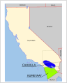
Historic distribution of Cahuilla
-
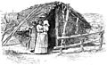
19th century Cahuilla hut
-
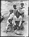
Cahuilla woman and children (1903)
-

Office of the Augustine Band of Cahuilla Indians
-

John Tortes "Chief" Meyers was a catcher in major league baseball


.jpg)


