
Banning, California facts for kids
Quick facts for kids
Banning, California
|
||
|---|---|---|
|
||
| Nickname(s):
"Gateway to the Coachella Valley"
|
||
| Motto(s):
"Endless Opportunity"
|
||

Location of Banning in Riverside County, California.
|
||

Banning, California
Location in the United States
|
||
| Country | ||
| State | ||
| County | ||
| Incorporated | February 6, 1913 | |
| Government | ||
| • Type | Council-Manager | |
| • Body | Banning City Council Dave Happe Mary Hamlin Alberto Sanchez |
|
| Area | ||
| • Total | 23.24 sq mi (60.18 km2) | |
| • Land | 23.24 sq mi (60.18 km2) | |
| • Water | 0.00 sq mi (0.00 km2) 0% | |
| Elevation | 2,349 ft (716 m) | |
| Population
(2020)
|
||
| • Total | 29,505 | |
| • Density | 1,269.74/sq mi (490.25/km2) | |
| Time zone | UTC-8 (Pacific) | |
| • Summer (DST) | UTC-7 (PDT) | |
| ZIP code |
92220
|
|
| Area code | 951 | |
| FIPS code | 06-03820 | |
| GNIS feature IDs | 1660306, 2409785 | |

Banning is a city in Riverside County, California, USA. In 2020, about 29,505 people lived there. The city is located in the San Gorgonio Pass, also called Banning Pass. It is named after Phineas Banning, who owned a stagecoach line. He is also known as the "Father of the Port of Los Angeles."
Banning is close to its western neighbor, Beaumont. Both cities have grown a lot since the 1990s. They are about 80 miles (129 km) east of downtown Los Angeles. They are also 30 miles (48 km) west of Palm Springs. Freeways and railroads connect both cities.
Contents
History of Banning
How Banning Got Its Name
The town was first called Moore City. This name came from Ransom B. Moore. But after only a few months, the town was renamed Banning. It was named after Phineas Banning. He used to graze sheep in the San Gorgonio Pass area. He also ran a stagecoach service through the Pass.
Early Days of the City
Long ago, the Cahuilla people lived in this area. The region around Banning was originally home to the Maringayam (Serrano) people. In 1824, the Mission San Gabriel Arcángel started a ranch called Rancho San Gorgonio in the pass. The first American settler was Dr. Isaac Smith in 1853.
In 1863, a smallpox disease greatly reduced the Cahuilla population. The government later created Indian reservations for the Cahuilla in 1877.
Banning started to grow when the Colorado River Gold Rush began. The Bradshaw Trail was a wagon road built in 1862. It went through the area to gold towns in the Arizona Territory. Gilman's Ranch, north of downtown, was a stop for stagecoaches on this road.
The railroad came through Banning in 1876. The Southern Pacific Railroad (now part of Union Pacific) helped the area grow a lot. Later, major roads like U.S. Route 99 (in 1923) and U.S. Route 60/70 (in 1936) were built. Eventually, Interstate 10 followed.
Banning is next to the Morongo Indian Reservation. This is where the Morongo Band of Cahuilla Indians live. The town of Banning officially became a city on February 6, 1913.
Almond Farms
In the early 1900s, the area around Banning was perfect for growing almonds. It was known as the oldest almond growing area in southern California.
St. Boniface Indian School
The St. Boniface Indian Industrial School opened in 1890. It taught job skills to Cahuilla, Serrano, Luiseño, Kumeyaay, and other Native American students. About 8,000 students attended the school over its history. The school was taken down in 1974, but a small cemetery remains.
Banning During World War II
During World War II, Banning had a large hospital called Banning General Hospital. It had 1,000 beds. This hospital helped soldiers training at the Desert Training Center. Later, it became a hospital for recovering naval patients. The hospital buildings were removed in 1948.
In 1942, the people of Banning raised money to buy an M3 Stuart tank for the war. After the war, the tank was given to the South African Defence Force. This tank, named "City of Johannesburg," is now in a museum in Richmond, South Africa.
Geography of Banning
Banning is located at 33°55′54″N 116°53′51″W / 33.93167°N 116.89750°W.
The city covers about 23.1 square miles (60.1 square kilometers) of land. Banning is about 2,300 feet (701 meters) above sea level. This higher elevation gives it a cooler climate. For example, Riverside is only about 800 feet (244 meters) above sea level.
The San Andreas Fault runs through Banning. This fault created the pass where the city is located. Banning is about 25 miles (40 km) west of Palm Springs. It is also about 100 miles (161 km) east of Los Angeles.
Banning's Climate
Banning has a warm-summer Mediterranean climate. This means it has hot, dry summers and mild, wet winters.
Population and People
| Historical population | |||
|---|---|---|---|
| Census | Pop. | %± | |
| 1930 | 2,752 | — | |
| 1940 | 3,874 | 40.8% | |
| 1950 | 7,034 | 81.6% | |
| 1960 | 10,250 | 45.7% | |
| 1970 | 12,034 | 17.4% | |
| 1980 | 14,020 | 16.5% | |
| 1990 | 20,570 | 46.7% | |
| 2000 | 23,562 | 14.5% | |
| 2010 | 29,603 | 25.6% | |
| 2020 | 29,505 | −0.3% | |
| U.S. Decennial Census | |||
In 2010, Banning had a population of 29,603 people. About 95.4% of the people lived in homes. The average household size was about 2.61 people.
In 2010, about 22.9% of the population was under 18 years old. About 25.9% of the population was 65 years or older. The average age in Banning was 42.3 years.
In 2000, there were 23,562 people living in Banning. About 26.4% of the population was under 18. About 26.8% was 65 or older. The average age was 41 years.
Fun Things to Do in Banning
Events
Banning Stagecoach Days is a yearly event. It has been held since 1957. It celebrates the city's history with stagecoaches. Phineas Banning, the city's namesake, was a stagecoach operator. The event is held at the AC Dysart Equestrian Park.
Places to Visit
- Gilman Ranch Historic Park
- Gilman Historic Ranch and Wagon Museum
Public Services
Safety Services
Banning has its own police department. Other police departments, like Beaumont and Palm Springs, can help in big emergencies. The California Highway Patrol also helps. The Morongo Tribal Police Department serves the nearby Morongo Reservation.
The city also has fire and paramedic services. These are provided by the Riverside County Fire Department. They work with CAL FIRE.
Education
Most of Banning is part of the Banning Unified School District. Some parts are in the Beaumont Unified School District.
Schools in the Banning USD include:
- Banning High School
- Cabazon Elementary
- Central Elementary
- Coombs Alternative Education
- Hemmerling Elementary
- Hoffer Elementary
- New Horizons High (Independent Studies)
- Nicolet Middle
The city also has a college campus. It is the San Gorgonio Pass Campus of Mt. San Jacinto College.
Getting Around Banning
Interstate 10 goes through Banning. It connects the city to Los Angeles in the west. It also connects to the Coachella Valley in the east. State Route 243 starts in Banning. It goes south to Idyllwild.
Banning has its own airport, called Banning Municipal Airport. It has a 5,200-foot (1,585-meter) runway.
Pass Transit operates three bus routes in the city. Other bus services connect Banning to nearby cities. These include Palm Desert, Riverside, and Hemet.
Cemetery
The San Gorgonio Memorial Park is a cemetery in Banning. It was started in 1931. A famous person buried there is Medal of Honor winner William Powers Morris.
Library
The Banning Public Library is operated by the Banning Library District. It was first started in 1916.
Famous People From Banning
- Johnny Longden
- Sally Sweetland
- Earl Palmer
- John Doucette
Images for kids
-
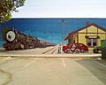
Public art in the City of Banning
-
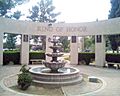
The City of Banning Ring of Honor


See also
 In Spanish: Banning (California) para niños
