
Coachella Valley facts for kids
Quick facts for kids Coachella Valley |
|
|---|---|

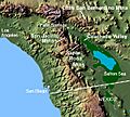
Coachella Valley
|
|
| Width | 15 miles (24 km) |
| Naming | |
| Native name | Error {{native name}}: an IETF language tag as parameter {{{1}}} is required (help) |
| Geography | |
| Location | Riverside County, California, United States |
| Population centers | Indio, Palm Springs, Palm Desert |
| Borders on | Salton Sea (southeast), Santa Rosa Mountains (southwest), San Jacinto Mountains (west), Little San Bernardino Mountains (east), San Gorgonio Mountain (north) |
| Traversed by | Interstate 10 |
The Coachella Valley is a dry valley in the Colorado Desert part of Southern California. It's located in Riverside County. People sometimes call it Greater Palm Springs or the Palm Springs Area because Palm Springs is a very famous city there.
The valley stretches about 45 miles (72 km) southeast from the San Gorgonio Pass to the northern edge of the Salton Sea. It's about 15 miles (24 km) wide. Mountains surround it: the San Bernardino and Little San Bernardino Mountains to the northeast, and the San Jacinto and Santa Rosa Mountains to the southwest.
The Coachella Valley is well-known for its many resort cities. These places are popular winter getaways for people who want to escape colder weather. The valley also hosts exciting yearly events. These include the Coachella Valley Music and Arts Festival, the Stagecoach Country Music Festival, and the Riverside County Fair and National Date Festival. All of these big events happen in Indio. Other fun events are the Palm Springs Modernism Week, the Palm Springs International Film Festival, and major golf and tennis tournaments.
Cities in the Coachella Valley include Cathedral City, Coachella, Desert Hot Springs, Indian Wells, Indio, La Quinta, Palm Desert, Palm Springs, and Rancho Mirage.
Summers in the valley are super hot, but winters are mild and pleasant. Because of this, the number of people living here changes a lot. In April, there might be almost 500,000 people, but in July and August, it drops to around 300,000. By January, it can reach about 600,000. In 2013, about 3.5 million tourists and visitors came to the valley each year.
The Coachella Valley connects to the Greater Los Angeles area through the San Gorgonio Pass. This pass is a key route for travel, used by Interstate 10 and the Union Pacific Railroad. The valley is part of the "Low Desert," which is different from the larger Inland Empire in Southern California.
Contents
History of the Valley
Early Explorers and Growth
In 1857, Edward Fitzgerald Beale explored this area. His team even used camels to cross the desert! The valley really started to grow when the Southern Pacific Railroad arrived. Also, many natural water sources called artesian wells were found in the late 1800s.
Later, in 1926, U.S. Route 99 was built. This road went through Coachella and Indio, connecting the valley to Los Angeles. This helped farming, businesses, and tourism grow. In the early 1930s, State Highway 111 was also built. It cut across the valley, linking all the main towns.
Dr. June McCarroll, a nurse, is famous for a big idea that started in Indio. She was the first person to paint a stripe down the middle of the road. This helped prevent head-on crashes. Her idea became a worldwide standard! A part of Interstate 10 through Indio is named after her.
A Place for Stars
The Coachella Valley became a popular spot for famous people, from Frank Sinatra to other celebrities. They loved to visit or own winter homes in this desert resort area. In the 1980s and 1990s, it became a top place for buying homes and a major tourist spot.
Geography and Nature
Valley Shape and Mountains
The Coachella Valley is the northern end of a huge sunken area called the Salton Trough. This area includes the Salton Sea and the Imperial Valley in the U.S., plus parts of Mexico. This valley was formed by the movement of Earth's plates. The San Andreas Fault runs along the northeast side of the valley.

Tall mountains surround the valley. To the southwest are the Santa Rosa Mountains. To the west are the San Jacinto Mountains. The Little San Bernardino Mountains are to the east, and San Gorgonio Mountain is to the north. These mountains are very high, often between 5,000 and 7,000 feet (1,500 to 2,100 meters) tall. The valley floor itself ranges from 1,600 feet (490 meters) above sea level in the north to 250 feet (76 meters) below sea level near Mecca.
Earthquakes and Hot Springs
Because the San Andreas Fault runs through the valley, there are many hot springs. These natural hot water sources made it possible for people to live and build towns in this desert. Earthquakes have happened here. For example, the 1986 North Palm Springs earthquake was a 6.0 magnitude quake that caused some damage.
Climate and Weather
Summers in the Coachella Valley are extremely hot, with daytime temperatures often reaching 104°F to 112°F (40°C to 44°C). Nights are warm too. In winter, it's much milder, with daytime temperatures from 68°F to 88°F (20°C to 31°C). This makes it a popular winter vacation spot. The warm weather all year helps farmers grow fruits like mangoes, figs, and dates.
The valley is very dry, like a desert. Most rain falls in winter. In summer, some moisture comes from the Gulf of Mexico and the Gulf of California. Sometimes, even a tropical storm can bring heavy rain, like Tropical Storm Kathleen did in 1976, causing big floods. Dust storms called haboobs can also happen every couple of years.
| Climate data for Palm Springs, CA (1991–2020 Normals) | |||||||||||||
|---|---|---|---|---|---|---|---|---|---|---|---|---|---|
| Month | Jan | Feb | Mar | Apr | May | Jun | Jul | Aug | Sep | Oct | Nov | Dec | Year |
| Record high °F (°C) | 95 (35) |
99 (37) |
104 (40) |
112 (44) |
116 (47) |
123 (51) |
123 (51) |
123 (51) |
121 (49) |
116 (47) |
102 (39) |
93 (34) |
123 (51) |
| Mean daily maximum °F (°C) | 70.5 (21.4) |
73.7 (23.2) |
80.6 (27.0) |
86.7 (30.4) |
94.7 (34.8) |
103.6 (39.8) |
108.6 (42.6) |
108.1 (42.3) |
101.8 (38.8) |
91.1 (32.8) |
78.7 (25.9) |
69.2 (20.7) |
88.9 (31.6) |
| Daily mean °F (°C) | 59.0 (15.0) |
61.7 (16.5) |
67.5 (19.7) |
72.9 (22.7) |
80.3 (26.8) |
88.2 (31.2) |
94.0 (34.4) |
94.0 (34.4) |
88.1 (31.2) |
77.8 (25.4) |
66.0 (18.9) |
57.7 (14.3) |
75.6 (24.2) |
| Mean daily minimum °F (°C) | 47.6 (8.7) |
49.7 (9.8) |
54.4 (12.4) |
59.1 (15.1) |
65.9 (18.8) |
72.7 (22.6) |
79.4 (26.3) |
79.8 (26.6) |
74.4 (23.6) |
64.5 (18.1) |
53.4 (11.9) |
46.2 (7.9) |
62.3 (16.8) |
| Record low °F (°C) | 19 (−7) |
24 (−4) |
29 (−2) |
34 (1) |
36 (2) |
44 (7) |
54 (12) |
52 (11) |
46 (8) |
30 (−1) |
23 (−5) |
23 (−5) |
19 (−7) |
| Average precipitation inches (mm) | 1.16 (29) |
1.16 (29) |
0.49 (12) |
0.05 (1.3) |
0.02 (0.51) |
0.02 (0.51) |
0.14 (3.6) |
0.29 (7.4) |
0.22 (5.6) |
0.20 (5.1) |
0.38 (9.7) |
0.70 (18) |
4.83 (123) |
| Average precipitation days | 3.8 | 3.5 | 2.4 | 0.7 | 0.4 | 0.2 | 0.7 | 1.1 | 1.0 | 0.8 | 1.0 | 2.6 | 18.2 |
| Source: NOAA | |||||||||||||
| Climate data for Boyd Deep Canyon Campground (1982–2012) Elev. 682 ft. | |||||||||||||
|---|---|---|---|---|---|---|---|---|---|---|---|---|---|
| Month | Jan | Feb | Mar | Apr | May | Jun | Jul | Aug | Sep | Oct | Nov | Dec | Year |
| Mean daily maximum °F (°C) | 69.8 (21.0) |
72.1 (22.3) |
78.6 (25.9) |
85.3 (29.6) |
93.4 (34.1) |
101.7 (38.7) |
105.6 (40.9) |
104.5 (40.3) |
99.5 (37.5) |
89.4 (31.9) |
77.4 (25.2) |
68.2 (20.1) |
87.1 (30.6) |
| Daily mean °F (°C) | 59.7 (15.4) |
61.7 (16.5) |
66.7 (19.3) |
72.1 (22.3) |
79.1 (26.2) |
86.7 (30.4) |
92.3 (33.5) |
91.6 (33.1) |
86.9 (30.5) |
77.9 (25.5) |
66.8 (19.3) |
59.3 (15.2) |
75.0 (23.9) |
| Mean daily minimum °F (°C) | 49.5 (9.7) |
51.3 (10.7) |
54.7 (12.6) |
58.8 (14.9) |
64.8 (18.2) |
71.6 (22.0) |
79.0 (26.1) |
78.6 (25.9) |
74.3 (23.5) |
66.4 (19.1) |
56.1 (13.4) |
48.4 (9.1) |
62.8 (17.1) |
| Average precipitation inches (mm) | 0.68 (17) |
0.80 (20) |
0.40 (10) |
0.07 (1.8) |
0.04 (1.0) |
0.01 (0.25) |
0.29 (7.4) |
0.48 (12) |
0.37 (9.4) |
0.21 (5.3) |
0.29 (7.4) |
0.61 (15) |
4.20 (107) |
| Source: deepcanyon.ucnrs.org | |||||||||||||
| Climate data for Indio, CA (Lower Valley) | |||||||||||||
|---|---|---|---|---|---|---|---|---|---|---|---|---|---|
| Month | Jan | Feb | Mar | Apr | May | Jun | Jul | Aug | Sep | Oct | Nov | Dec | Year |
| Record high °F (°C) | 97 (36) |
100 (38) |
103 (39) |
109 (43) |
117 (47) |
123 (51) |
125 (52) |
121 (49) |
122 (50) |
115 (46) |
101 (38) |
93 (34) |
125 (52) |
| Mean daily maximum °F (°C) | 71.9 (22.2) |
75.3 (24.1) |
81.3 (27.4) |
87.5 (30.8) |
95.7 (35.4) |
103.1 (39.5) |
107.3 (41.8) |
106.6 (41.4) |
102.0 (38.9) |
91.9 (33.3) |
79.6 (26.4) |
71.0 (21.7) |
89.5 (31.9) |
| Daily mean °F (°C) | 58.3 (14.6) |
61.6 (16.4) |
68.1 (20.1) |
74.1 (23.4) |
81.7 (27.6) |
88.6 (31.4) |
93.8 (34.3) |
93.4 (34.1) |
88.0 (31.1) |
77.8 (25.4) |
65.7 (18.7) |
57.6 (14.2) |
75.8 (24.3) |
| Mean daily minimum °F (°C) | 44.6 (7.0) |
48.0 (8.9) |
54.8 (12.7) |
60.7 (15.9) |
67.7 (19.8) |
74.2 (23.4) |
80.3 (26.8) |
80.3 (26.8) |
74.0 (23.3) |
63.7 (17.6) |
51.8 (11.0) |
44.2 (6.8) |
62.1 (16.7) |
| Record low °F (°C) | 13 (−11) |
20 (−7) |
25 (−4) |
33 (1) |
38 (3) |
45 (7) |
59 (15) |
56 (13) |
46 (8) |
31 (−1) |
23 (−5) |
19 (−7) |
13 (−11) |
| Average precipitation inches (mm) | 0.56 (14) |
0.64 (16) |
0.43 (11) |
0.05 (1.3) |
0.07 (1.8) |
0.01 (0.25) |
0.04 (1.0) |
0.54 (14) |
0.04 (1.0) |
0.26 (6.6) |
0.18 (4.6) |
0.62 (16) |
3.44 (87) |
| Source: www.ncdc.noaa.gov | |||||||||||||
Desert Plants and Animals
This desert area is home to many unique plants and animals. You can find the California Fan Palm, which is an endangered tree. Bighorn sheep live in the Santa Rosa and San Jacinto mountains. The fringe-toed lizard, a desert reptile, is also found here. Other animals include bobcats, coyotes, foxes, kangaroo rats, rattlesnakes, roadrunners, and scorpions.
People and Communities
Who Lives Here?
Many people who live in the Coachella Valley are 65 or older. This area has some of the highest numbers of senior citizens in California. For example, Indian Wells, Rancho Mirage, and Palm Desert have many older residents.
The valley has a diverse history with many different groups of people. In 2004, studies showed that about 49.9% of residents were Hispanic, 44.7% were non-Hispanic White, and smaller percentages were Black, Asian, or Native American.
Early Residents
In the early 1900s, less than 1,000 people lived full-time in Palm Springs and the surrounding areas. By 1930, less than half of the Coachella Valley's population was "white." Many residents were Mexicans who worked on the railroads, and Native Americans from local tribes.
Starting in the 1890s, many Irish and Scottish people moved to the region. Palm Springs began as a farming community called "Palm Valley."
Hispanic Community
Hispanic Americans have lived in Palm Springs and the eastern valley for a long time. They have been the majority in cities like Indio and Coachella for many decades. Today, about half of the valley's residents are Latino. Many Latinos moving to the area come from Los Angeles and San Diego.
Most Hispanic residents are Mexican, with families who have lived here for generations. There are also people from Central America, Cuban Americans, Puerto Ricans, and South Americans. Many Hispanic immigrants came to work in farming. Today, they also work in construction, hotels, landscaping, and retail.
Other Groups
Native Americans from the Cahuilla tribe have a strong presence here. Many tribal members are very successful due to casino businesses and land ownership.
African Americans live in different parts of the valley, including Palm Springs, Indio, and Desert Hot Springs. There are also about 10,000 Indian Americans, whose families came as farm workers long ago. Palm Desert is also home to about 1,000 Tahitians.
Other groups who came to the area for farming in the early 1900s include Asian Americans (like Chinese, Japanese, and Filipinos), Armenians, and Arabs. More recently, people from Iran, Israel, and Korea have bought homes here.
Community Spirit
Palm Springs is known for being a welcoming place. City leaders have even talked about calling it a "hate-free zone" to celebrate its acceptance of different cultures. Many people choose to live here because of this open and friendly atmosphere.
Religious Life
Many different religions are practiced in the Coachella Valley. Protestants and Catholics are the largest groups. The valley also has one of California's biggest Jewish communities, with about 35,000 people. There's also a growing Mormon community. The Islamic Society of the Coachella Valley has a mosque in the city of Coachella.
Cities and Population
The Coachella Valley has nine cities and several smaller communities.
| City | Population (2020 census) |
|---|---|
| Cathedral City | 51,493 |
| Coachella | 41,941 |
| Desert Hot Springs | 32,512 |
| Indian Wells | 4,757 |
| Indio | 89,137 |
| La Quinta | 37,558 |
| Palm Desert | 51,163 |
| Palm Springs | 44,575 |
| Rancho Mirage | 16,999 |
| Cities Total | 370,135 |
In 2020, the cities in the Coachella Valley had about 370,000 people. Experts think the valley's population will reach over 1 million by 2066. Today, the total population is believed to be over 500,000, plus another 100,000 "snowbirds" who visit during the winter.
Palm Springs is at the northwest end of the valley. Other communities include Cabazon, Bermuda Dunes, Thousand Palms, Indio Hills, Sky Valley, and Mecca. Several Native American tribes, like the Cahuilla, have reservations in the area.
Economy and Jobs
Farming in the Desert
Since the early 1900s, irrigation has allowed over 100,000 acres (40,000 ha) of land to be farmed. In 2006, the value of crops grown here was over $576 million. By 2010, it was about $600 million.
The valley is the main place in the United States where dates are grown. It produces almost 95% of the nation's dates! This is celebrated every year at the Riverside County Fair and National Date Festival in Indio. The first dates were brought from Iraq and Egypt in 1890. The date industry here started from experiments by a USDA horticulturist in the early 1900s. Most date farms today are in the "East Valley" near Coachella and La Quinta.
Other crops grown here include table grapes, citrus fruits (like lemons and oranges), onions, peppers, and mangoes. The city of Coachella is a major shipping point for these farm products.
Farming is a big reason why many families moved to the valley. Water for farming comes from an underground aquifer (a natural water storage) and the Coachella Canal. This canal was built between 1938 and 1948 and brings water from the Colorado River.
Wind Power
The entrance to the valley from Interstate 10 is called the San Gorgonio Pass. This is one of the windiest places in the country! Cool air from the coast blows through the pass and mixes with the hot desert air. This creates strong, steady winds perfect for generating electricity. At the San Gorgonio Pass Wind Farm, thousands of huge wind turbines spin across the desert. They have become a symbol of the area.
Local Businesses
The Coachella Valley is home to several important businesses:
- Siemens Water Technologies in Palm Desert makes systems for filtering industrial water.
- Guthy-Renker in Palm Desert produces TV commercials for products.
- Ernie Ball, a company that makes electric guitar strings, opened a factory in Coachella in 2005.
- Shields Date Gardens is a famous date producer and tourist spot since 1924.
- A Coca-Cola bottling plant in Coachella opened in 2009 and employs 1,000 people.
- Eisenhower Medical Center, a large hospital, employs about 2,800 people.
Fun Things to Do
With warm winters and over 350 sunny days a year, the Coachella Valley is great for outdoor activities. Hiking and horseback riding are popular in the many canyons.
Years ago, the valley was known as a good place for people with allergies or breathing problems because of its dry air. Today, many farms have been replaced by homes and golf courses. However, farming still thrives in the eastern part of the valley thanks to underground water.
Golf and Other Sports
There are about 125 golf courses here, making it one of the best golf destinations in the world! The PGA has a big presence in La Quinta with the PGA WEST complex.
The area also has casinos owned by local Native American tribes. There are six casinos in the Coachella Valley. Many resort hotels have spas with natural mineral water wells, especially in Desert Hot Springs.
Attractions and Events
The Palm Springs Aerial Tramway takes visitors from the valley floor up to the San Jacinto Peak mountain station, which is 8,516 feet (2,596 meters) above sea level.
Palm Springs is famous for its mid-century architecture. Thousands of buildings were designed in this style, attracting fans from all over.
- The Palm Springs International Film Festival happens every January.
- The Indian Wells Tennis Garden hosts the BNP Paribas Open tennis tournament each March.
- Every February, Indio hosts the Riverside County Fair and National Date Festival.
- Indio is also home to the annual Coachella Valley Music and Arts Festival, a huge music event at the Empire Polo Ground.
- You can explore desert nature at Joshua Tree National Park and the Sand to Snow National Monument.
- The Living Desert Zoo and Gardens in Palm Desert has animals from North America and Africa.
- The Coachella Valley History Museum in Indio preserves the valley's past.
Other fun activities include:
- An annual air show in Thermal in November.
- The Desert Circuit Horse Show, a big horse competition in Thermal.
- The Coachella Valley Firebirds, a hockey team, play at the Acrisure Arena in Palm Desert.
- The Palm Springs Power baseball team plays in summer, and the Palm Springs Chill plays in winter at Palm Springs Stadium.
- The College of the Desert in Palm Desert has sports teams called the Roadrunners.
- The Palm Springs Convention Center hosts many shows, concerts, and events.
- The Walter Annenberg Estate Museum is dedicated to a famous valley resident and philanthropist.
- You can enjoy art and food festivals like Modernism Week and the La Quinta Arts Festival.
Education in the Valley
The Coachella Valley has three public school districts:
- Coachella Valley Unified School District (Coachella)
- Desert Sands Unified School District (La Quinta, Indio, Palm Desert)
- Palm Springs Unified School District (Palm Springs, Cathedral City, Rancho Mirage, Desert Hot Springs)
There are 12 public high schools, including:
- Cathedral City High School
- Coachella Valley High School
- Desert Hot Springs High School
- Indio High School
- La Quinta High School (La Quinta, California)
- Palm Desert High School
- Palm Springs High School
- Rancho Mirage High School
For higher education, the College of the Desert (COD) is a community college with its main campus in Palm Desert. There are also branches of the University of California Riverside and California State University San Bernardino in Palm Desert.
Media and News
The Coachella Valley has its own TV and radio stations. The first TV station, KMIR channel 6, started in 1968.
The local daily newspaper is The Desert Sun. Other newspapers like the Los Angeles Times are also sold here. Palm Springs Life magazine focuses on the valley's wealthy residents. There are also independent publications like Coachella Valley Independent and Coachella Valley Weekly.
Television Channels
Many TV channels serve the valley, including local stations and some from nearby cities like San Diego and Phoenix.
- KMIR Channel 36 (NBC)
- KESQ Channel 42 (ABC)
- KDFX-CD Channel 33 (FOX)
- KPSP-CD Channels 38/42.2 (CBS)
- KCWQ-LD channel 20 (The CW)
- Spanish language channels like KEVC-CD (UniMas), KUNA-LD (Telemundo), and KVER-CD (Univision).
Radio Stations
There are many radio stations playing different types of music and news.
- The Eagle 106.9 FM (KDGL) plays Classic Hits.
- MIX 100.5 FM (KPSI) plays "The Desert's Best Mix."
- U92.7 FM (KKUU) plays Rhythmic Contemporary Hits.
- K-NEWS News Talk (KNWZ) provides news and talk shows.
- KCLB Rock 93.7 FM is the heritage Rock Station.
- The Bull 98.5 FM (KDES) plays Country Music.
- ESPN SPORTS Talk 103.9 FM (KKUU-HD2) covers sports.
Transportation
Getting Around
For air travel, the valley has the Palm Springs International Airport, Jacqueline Cochran Regional Airport in Thermal, and Bermuda Dunes Municipal Airport.
Interstate 10 runs along the northeast side of the valley. State Route 111 is the main highway connecting almost all the cities in the valley.
Public transportation is provided by the SunLine Transit Agency. They use buses powered by clean energy sources like fuel cells.
You can also travel by train with Amtrak from North Palm Springs. Greyhound buses connect the valley to Los Angeles and other places.
Famous People from the Valley
The Coachella Valley has been a popular home for many famous people, especially Hollywood stars, since the 1930s.
- Charles Farrell, an actor, helped start the Racquet Club of Palm Springs and later became mayor.
- Bing Crosby founded a unique trailer park in Rancho Mirage.
- Many classic stars like Humphrey Bogart, Judy Garland, and Fred Astaire visited Palm Springs.
- Medal of Honor recipients Captain William McGonagle and Mitchell Paige lived here.
- Jacqueline Cochran, a famous pilot, spent her last years in Indio.
- Bill Gates, the founder of Microsoft, reportedly owns a home in Indian Wells.
- Kirk Douglas, a famous actor, lived in the valley for over 50 years. A road at the Palm Springs Airport is named after him. His son, Michael Douglas, also has a home here.
- Lucille Ball and Desi Arnaz helped develop the Thunderbird Heights area in Rancho Mirage.
- The La Quinta Resort and Club, built in 1926, is the oldest resort. Frank Capra wrote the movie Lost Horizon there.
- Walt Disney loved his property at Smoke Tree Ranch in Palm Springs.
- Clint Eastwood used to own a restaurant in La Quinta.
- TV producer Merv Griffin owned a ranch that is now part of the PGA West community.
Many celebrities grew up in the area:
- Vanessa Marcil (actress) is from La Quinta.
- Suzanne Somers (actress) spent part of her childhood in Cathedral City.
- Alison Lohman (actress) grew up in Palm Desert.
- Tyler Hilton (singer/actor) is from Palm Springs.
- Jenna Ortega (actress) is from Indio.
U.S. President John F. Kennedy often visited Frank Sinatra here.
The area near Palm Desert was once a training ground for General George Patton's army troops during World War II. Today, it's home to the El Paseo shopping district.
Sonny Bono, a famous entertainer, became mayor of Palm Springs. He later served in the U.S. Congress. Both Sonny Bono and Frank Sinatra are buried in Cathedral City.
In Popular Culture
The Coachella Valley has appeared in many movies, TV shows, and books:
- The cartoon Bully for Bugs mentions the Coachella Valley and a "big carrot festival."
- The novel Generation X: Tales for an Accelerated Culture is set in Palm Springs in the late 1980s.
- Parts of the movie It's a Mad, Mad, Mad, Mad World were filmed here.
- The music video for Tears for Fears' song Everybody Wants to Rule the World was shot in the Coachella Valley, showing the famous windmills and the Salton Sea.
- The TV shows P.S. I Luv U and Phenom were set in Palm Springs.
- The 2007 film Alpha Dog was mostly filmed in Palm Springs.
- A helicopter scene in Mission: Impossible III was filmed in the wind farm outside Palm Springs.
- The video game Grand Theft Auto V features an area called Sandy Shores that is inspired by the Coachella Valley.
Images for kids
-
Coachella Valley
-
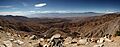
Panorama of the view south from Keys View in the Little San Bernardino Mountains, Joshua Tree National Park, California, United States. Visible landmarks are the Salton Sea, 230 feet (70 m) below sea level at rear left, along towards the center the Santa Rosa Mountains behind Indio and the San Jacinto Mountains behind Palm Springs. In the valley floor, the San Andreas Fault is clearly visible. At the rear right is the 11,500-foot tall (3,500 m) San Gorgonio Mountain.
-

The San Gorgonio Pass Wind Farm as viewed from the top of the Palm Springs Aerial Tramway in the San Jacinto Mountains to the south
| Climate data for Palm Springs, CA (1991–2020 Normals) | |||||||||||||
|---|---|---|---|---|---|---|---|---|---|---|---|---|---|
| Month | Jan | Feb | Mar | Apr | May | Jun | Jul | Aug | Sep | Oct | Nov | Dec | Year |
| Record high °F (°C) | 95 (35) |
99 (37) |
104 (40) |
112 (44) |
116 (47) |
123 (51) |
123 (51) |
123 (51) |
121 (49) |
116 (47) |
102 (39) |
93 (34) |
123 (51) |
| Mean daily maximum °F (°C) | 70.5 (21.4) |
73.7 (23.2) |
80.6 (27.0) |
86.7 (30.4) |
94.7 (34.8) |
103.6 (39.8) |
108.6 (42.6) |
108.1 (42.3) |
101.8 (38.8) |
91.1 (32.8) |
78.7 (25.9) |
69.2 (20.7) |
88.9 (31.6) |
| Daily mean °F (°C) | 59.0 (15.0) |
61.7 (16.5) |
67.5 (19.7) |
72.9 (22.7) |
80.3 (26.8) |
88.2 (31.2) |
94.0 (34.4) |
94.0 (34.4) |
88.1 (31.2) |
77.8 (25.4) |
66.0 (18.9) |
57.7 (14.3) |
75.6 (24.2) |
| Mean daily minimum °F (°C) | 47.6 (8.7) |
49.7 (9.8) |
54.4 (12.4) |
59.1 (15.1) |
65.9 (18.8) |
72.7 (22.6) |
79.4 (26.3) |
79.8 (26.6) |
74.4 (23.6) |
64.5 (18.1) |
53.4 (11.9) |
46.2 (7.9) |
62.3 (16.8) |
| Record low °F (°C) | 19 (−7) |
24 (−4) |
29 (−2) |
34 (1) |
36 (2) |
44 (7) |
54 (12) |
52 (11) |
46 (8) |
30 (−1) |
23 (−5) |
23 (−5) |
19 (−7) |
| Average precipitation inches (mm) | 1.16 (29) |
1.16 (29) |
0.49 (12) |
0.05 (1.3) |
0.02 (0.51) |
0.02 (0.51) |
0.14 (3.6) |
0.29 (7.4) |
0.22 (5.6) |
0.20 (5.1) |
0.38 (9.7) |
0.70 (18) |
4.83 (123) |
| Average precipitation days | 3.8 | 3.5 | 2.4 | 0.7 | 0.4 | 0.2 | 0.7 | 1.1 | 1.0 | 0.8 | 1.0 | 2.6 | 18.2 |
| Source: NOAA | |||||||||||||
| Climate data for Boyd Deep Canyon Campground (1982–2012) Elev. 682 ft. | |||||||||||||
|---|---|---|---|---|---|---|---|---|---|---|---|---|---|
| Month | Jan | Feb | Mar | Apr | May | Jun | Jul | Aug | Sep | Oct | Nov | Dec | Year |
| Mean daily maximum °F (°C) | 69.8 (21.0) |
72.1 (22.3) |
78.6 (25.9) |
85.3 (29.6) |
93.4 (34.1) |
101.7 (38.7) |
105.6 (40.9) |
104.5 (40.3) |
99.5 (37.5) |
89.4 (31.9) |
77.4 (25.2) |
68.2 (20.1) |
87.1 (30.6) |
| Daily mean °F (°C) | 59.7 (15.4) |
61.7 (16.5) |
66.7 (19.3) |
72.1 (22.3) |
79.1 (26.2) |
86.7 (30.4) |
92.3 (33.5) |
91.6 (33.1) |
86.9 (30.5) |
77.9 (25.5) |
66.8 (19.3) |
59.3 (15.2) |
75.0 (23.9) |
| Mean daily minimum °F (°C) | 49.5 (9.7) |
51.3 (10.7) |
54.7 (12.6) |
58.8 (14.9) |
64.8 (18.2) |
71.6 (22.0) |
79.0 (26.1) |
78.6 (25.9) |
74.3 (23.5) |
66.4 (19.1) |
56.1 (13.4) |
48.4 (9.1) |
62.8 (17.1) |
| Average precipitation inches (mm) | 0.68 (17) |
0.80 (20) |
0.40 (10) |
0.07 (1.8) |
0.04 (1.0) |
0.01 (0.25) |
0.29 (7.4) |
0.48 (12) |
0.37 (9.4) |
0.21 (5.3) |
0.29 (7.4) |
0.61 (15) |
4.20 (107) |
| Source: deepcanyon.ucnrs.org | |||||||||||||
| Climate data for Indio, CA (Lower Valley) | |||||||||||||
|---|---|---|---|---|---|---|---|---|---|---|---|---|---|
| Month | Jan | Feb | Mar | Apr | May | Jun | Jul | Aug | Sep | Oct | Nov | Dec | Year |
| Record high °F (°C) | 97 (36) |
100 (38) |
103 (39) |
109 (43) |
117 (47) |
123 (51) |
125 (52) |
121 (49) |
122 (50) |
115 (46) |
101 (38) |
93 (34) |
125 (52) |
| Mean daily maximum °F (°C) | 71.9 (22.2) |
75.3 (24.1) |
81.3 (27.4) |
87.5 (30.8) |
95.7 (35.4) |
103.1 (39.5) |
107.3 (41.8) |
106.6 (41.4) |
102.0 (38.9) |
91.9 (33.3) |
79.6 (26.4) |
71.0 (21.7) |
89.5 (31.9) |
| Daily mean °F (°C) | 58.3 (14.6) |
61.6 (16.4) |
68.1 (20.1) |
74.1 (23.4) |
81.7 (27.6) |
88.6 (31.4) |
93.8 (34.3) |
93.4 (34.1) |
88.0 (31.1) |
77.8 (25.4) |
65.7 (18.7) |
57.6 (14.2) |
75.8 (24.3) |
| Mean daily minimum °F (°C) | 44.6 (7.0) |
48.0 (8.9) |
54.8 (12.7) |
60.7 (15.9) |
67.7 (19.8) |
74.2 (23.4) |
80.3 (26.8) |
80.3 (26.8) |
74.0 (23.3) |
63.7 (17.6) |
51.8 (11.0) |
44.2 (6.8) |
62.1 (16.7) |
| Record low °F (°C) | 13 (−11) |
20 (−7) |
25 (−4) |
33 (1) |
38 (3) |
45 (7) |
59 (15) |
56 (13) |
46 (8) |
31 (−1) |
23 (−5) |
19 (−7) |
13 (−11) |
| Average precipitation inches (mm) | 0.56 (14) |
0.64 (16) |
0.43 (11) |
0.05 (1.3) |
0.07 (1.8) |
0.01 (0.25) |
0.04 (1.0) |
0.54 (14) |
0.04 (1.0) |
0.26 (6.6) |
0.18 (4.6) |
0.62 (16) |
3.44 (87) |
| Source: www.ncdc.noaa.gov | |||||||||||||
See also
 In Spanish: Valle de Coachella para niños
