
Imperial Valley facts for kids
Quick facts for kids Imperial Valley |
|
|---|---|

The Imperial Valley below the Salton Sea. The US-Mexican border is a diagonal line in the lower left of the image.
|
|

Map of Imperial Valley
|
|
| Length | 50 miles (80 km) Northwest-Southeast |
| Geography | |
| Location | California, United States |
| Population centers | Brawley, Calexico, El Centro, Imperial |
| Traversed by | Interstate 8, State Route 78, State Route 86, State Route 111 |
The Imperial Valley (also called Valle Imperial in Spanish) is a special place in southeastern California. It's mostly in Imperial County and a bit in Riverside County. The main city here is El Centro.
This valley is unique because it's bordered by the Colorado River to the east and the Salton Sea to the west. To the south, it touches the border with Baja California, Mexico. This means the area has a cool mix of United States and Mexico cultures! The main way people make a living here is through farming.
The Imperial Valley got its name from the Imperial Land Company. They hoped the name would attract more people to settle there. Today, "Imperial Valley" and "Imperial County" often mean the same thing to local people.
Contents
- Exploring the Imperial Valley's Geography
- People of the Imperial Valley
- Imperial Valley's Economy
- Who Lives Here: Demographics
- Politics in the Imperial Valley
- Learning in the Imperial Valley: Education
- Getting Around: Transportation
- Imperial Valley in Movies and Books
- Images for kids
- See also
Exploring the Imperial Valley's Geography
The Imperial Valley stretches about 50 miles (80 km) south from the Salton Sea all the way into Mexico. It's part of a bigger dip in the land called the Salton Trough. This trough goes from the Coachella Valley to the Gulf of California.
Did you know that most of the Imperial Valley is actually below sea level? Near the Salton Sea, it's about 235 feet (72 m) below sea level! The climate here is a hot desert, with big changes in temperature each day.
Long ago, this valley was part of the Gulf of California. But the Colorado River brought so much dirt and sand that it built a natural dam, cutting off the valley from the gulf. Before 1901, the valley was mostly empty. Then, the Alamo Canal was built to bring water from the Colorado River. This allowed people to start farming.
In 1905-1907, floods damaged the canals and created the Salton Sea. Now, the New River and water from farms keep the Salton Sea full. Rivers in the southern part of the valley flow north into the Salton Sea.
Imperial Valley's Climate
The Imperial Valley gets super hot in the summer, often over 100 °F (38 °C). But from late October to mid-April, the weather is much milder. Sometimes, it even gets surprisingly cool for a desert!
This valley is one of the sunniest places in the United States. In winter, it gets more than eight hours of sunshine every day.
The coldest temperature ever recorded here was 16 °F (−9 °C) in 1937. The hottest was 121 °F (49 °C) in 1995. It doesn't rain much, with an average of only 2.93 inches (74 mm) per year. The driest month is June.
Guess what? It even snowed once! On December 12, 1932, about 2.5 inches (6 cm) of snow fell across the whole valley. It was the only time that has happened!
People of the Imperial Valley
The El Centro area is home to about 182,972 people (as of 2017). This includes all of Imperial County. The main cities where people live are Brawley, Calexico, and El Centro. El Centro is the main city and the county seat.
Imperial County has been growing fast! Between 2008 and 2009, it had the biggest population increase in California. It's been one of the top 10 fastest-growing counties in California for the past six years.
El Centro is the biggest business hub in the Imperial Valley. It's a center for shipping goods, shopping, and jobs in farming and transportation. There are also two border crossings nearby for cars and trucks going into Mexico. El Centro is about 50 feet (20 m) below sea level, making it the largest city in the U.S. that's below sea level. Many jobs in El Centro are in shops and services.
Imperial Valley Communities
The Imperial Valley has different types of towns.
- Salton Beach Towns: These are smaller towns near the Salton Sea. They used to be popular resorts but have shrunk over time.
- Desert Cities: These towns are a bit further away from the main cities and tend to be smaller.
- El Centro Area: These are the larger, more developed cities around El Centro.
The southeastern part of California, including the Imperial Valley, has many residents with lower incomes.
Cities with Over 10,000 People
Cities with Under 10,000 People
Towns with Over 1,000 People
Towns with Under 1,000 People
Urban Areas in the Region
The El Centro area is a metropolitan region with several urban areas. Here are some of the larger ones:
| Population rank |
Name | State(s) | Type (UA/UC) | 2017 population |
|---|---|---|---|---|
| 1 | Yuma | CA-AZ | UA | 95,542 |
| 2 | El Centro | CA | UA | 56,006 |
| 3 | Calexico | CA | UC | 40,131 |
| 4 | Brawley | CA | UC | 26,747 |
| 5 | Imperial | CA | UC | 18,701 |
| 6 | Calipatria | CA | UC | 7,506 |
| 7 | Holtville | CA | UC | 6,597 |
Imperial Valley's Economy
The economy of Imperial County mainly relies on government jobs, agriculture, and shopping. These three areas make up about 70% of all jobs in the county. Government services provide over a third of the jobs.
Farming creates about a fourth of the jobs. Important crops grown here include alfalfa, lettuce, sugar beets, and carrots. Shopping has grown a lot because more people live here and also because visitors come from Mexicali. In 2005, the Imperial Valley Mall opened, which brings in many shoppers from both sides of the border.
Fun Things to Do: Tourism in the Valley
Tourism is the second biggest industry in the Imperial Valley. Many people visit the Salton Sea, which is California's largest inland lake. It collects extra water and drainage from the farms. The Algodones Dunes are also a very popular spot. The New River and the Alamo River flow from Mexicali in Mexico north to the Salton Sea.
Another cool place to see are the Salton Sea mud pots and volcanoes. These are natural bubbling mud pits and small mud volcanoes. They are caused by heat deep underground. The mud is usually warm, and you can walk close to them, but always be careful as temperatures can change.
Off-roading on ATVs (all-terrain vehicles) is a favorite activity in the winter. The Heber Dunes State Vehicular Recreation Area is a great place for this. The sand dunes attract hundreds of thousands of off-road fans on busy weekends.
If you like nature, bird-watching is popular because there are many different birds and habitats. The Imperial Valley also has great golf courses in Holtville, Brawley, and El Centro.
Cool Places to Visit
Fort Yuma
Fort Yuma is located by the Colorado River in Winterhaven, California. It was built after the Mexican–American War in 1848. Its job was to protect the new town of Yuma, Arizona and the nearby Mexican border. It also helped protect travelers going to California and tried to keep peace with the Quechan people in the area.
Blue Angels
NAF El Centro is where the famous U.S. Navy Flight Demonstration Squadron, The Blue Angels practice in the winter. They usually start their air show season here in March with their first big show.
Imperial Valley Expo & Fairgrounds
This is where the California Mid-Winter Fair and Fiesta happens, which is the local county fair. It also has the Imperial Valley Speedway, a 3⁄8 mile (600 m) race track for car races.
Algodones Sand Dunes


The Algodones Dunes are the biggest sand dunes in California! They stretch for over 40 miles (60 km) along the eastern edge of the Imperial Valley. They are about 5 miles (8 km) wide. Part of the dunes is a wilderness area where you can only hike or ride horses.
The largest and most used part of the dunes is great for ATV and off-roading fans. The dunes are also famous for being used in movies like Return of the Jedi.
Colorado River

The Colorado River is a popular spot for water sports like fishing, boating, water-skiing, and jet-skiing. This big river flows through the southwestern United States and northwestern Mexico. It's about 1,450 miles (2,330 km) long. It starts in the Rocky Mountains and naturally flows to the Gulf of California. However, because people use so much water, the river often doesn't reach the gulf for many months of the year.
Salvation Mountain
Salvation Mountain is a colorful, man-made mountain north of Calipatria, California. It's made from mud, straw, and thousands of gallons of paint. A man named Leonard Knight created it to share the message that "God Loves Everyone." He didn't want to change his message, even when people offered him money to do so.
Anza-Borrego Desert State Park

Anza-Borrego Desert State Park is the largest state park in California. Parts of it are in Imperial County. It has 500 miles (800 km) of dirt roads, 12 wilderness areas, and many hiking trails. It's a great place to explore the Colorado Desert.
The park is named after a Spanish explorer, Juan Bautista de Anza, and the Spanish word borrego, which means bighorn sheep. You can see washes, wildflowers, palm groves, and cacti here. You might also spot greater roadrunners, golden eagles, kit foxes, mule deer, and Peninsular bighorn sheep. Look out for desert iguanas, chuckwallas, and sidewinders too!
Fossil Canyon and Painted Gorge
Near Ocotillo, California, in the Coyote Mountains, you'll find Fossil Canyon. It's a cool place to look for rocks and fossils. The fossils here aren't dinosaurs, but ancient shells, coral, and oysters. They are from a time long ago when this area was underwater.
The Painted Gorge is on the eastern side of the Coyote Mountains. It has different kinds of rocks like sedimentary, metamorphic, and igneous rocks. Over time, heat and movement have shaped these rocks into amazing forms and colors. You'll see oranges, reds, purples, and mauves mixed with browns and blacks, creating a beautiful natural painting.
Imperial National Wildlife Refuge

The Imperial National Wildlife Refuge protects animals and their homes along 30 miles (50 km) of the lower Colorado River. This includes the last part of the river that hasn't been changed by humans before it enters Mexico. The river and its lakes are like a green oasis in the middle of the desert mountains. It's a safe place for birds that migrate and for local desert animals to live and have their babies.
Sonny Bono Salton Sea National Wildlife Refuge

The Sonny Bono Salton Sea National Wildlife Refuge is about 40 miles (60 km) north of the Mexican border. It's at the southern end of the Salton Sea. This refuge is special because it's 227 feet (69 m) below sea level! It's also on the Pacific Flyway, which is a path many birds use when they migrate. Because of its location in the Colorado Desert, it gets some of the hottest temperatures in the country. From May to October, daily temperatures are usually over 100 °F (38 °C).
Mexicali
The border city of Mexicali, Baja California, Mexico, is a fun place to visit. It has museums, a zoo, and a sports center. Many visitors cross from Calexico, California every day. You can find restaurants, taco stands, pharmacies, bars, and dance clubs. There are also many shops selling Mexican crafts and souvenirs close to the border. People from the U.S. often go to Mexicali for medical and dental services because they can be less expensive. Since the drinking age in Mexico is 18, it's a popular weekend spot for high school and college students from Southern California.
Farming in the Valley


Even though the Imperial Valley is in the Colorado Desert and gets very hot with only about 3 inches (76 mm) of rain each year, farming is a huge part of its economy. This is all thanks to irrigation! Water comes from the Colorado River through the All-American Canal.
Thousands of acres of desert land have been turned into some of the most productive farms in California. They produce over $1 billion worth of crops every year! Farming is the biggest industry in the Imperial Valley, providing 48% of all jobs. One downside is that south of the canal, the Colorado River often doesn't flow above ground into Mexico for much of the year.
A huge system of canals, dams, and pipelines carries water all over the valley. This system is managed by the Imperial Irrigation District, or IID. It includes over 1,400 miles (2,300 km) of canals and 1,100 miles (1,800 km) of pipelines.
Because of the imported water and a long growing season, farmers can grow two sets of crops each year. The Imperial Valley is a major source of winter fruits and vegetables, cotton, and grain for the U.S. and other countries. Alfalfa is another big crop. Water that runs off the farms goes into the Salton Sea, which helps keep the sea full.
- All-American Canal
- All-American Canal Bridge
- Alamo Canal
- Coachella Canal
- Imperial Irrigation District
- Imperial Land Company
- California Development Company
Green Energy in the Valley

The Imperial Valley is becoming a big center for renewable energy projects, especially solar and geothermal power. This is happening because California wants to get 33% of its electricity from renewable sources by 2020. The valley has lots of sunshine, high unemployment, is close to big cities, and has large areas of empty desert land.
Much of the land perfect for green energy is owned by the government. As of April 2008, the government received 163 requests to build renewable energy projects on 1,600,000 acres (6,500 km2) in California. Almost all of these are planned for the Imperial Valley!
For example, Stirling Energy Systems is building one of the world's largest solar thermal power plants here. It will cover 10 square miles (26 km2) and have 38,000 "sun catchers." Once it's fully working around 2015, it will power up to 600,000 homes. CalEnergy runs a geothermal plant that makes enough power for 300,000 homes. They could even make enough for 2.5 million homes!
Also, in 2012, a company called Synthetic Genomics bought land in the Imperial Valley to make algae fuel using special algae.
Who Lives Here: Demographics
The Imperial and Mexicali Valleys share a special connection between American and Hispanic cultures. On the U.S. side, most people are of Mexican-American or Latino background. On the Mexican side, American culture has had a big influence for many years. People from many different backgrounds live here, including Africans, Europeans, East and South Asians, and Native Americans.
In 2000, there were 142,361 people living in the county. About 72.2% of the population were Hispanic or Latino. Most people (65.7%) spoke Spanish as their first language, while 32.3% spoke English.
About 31.4% of the people were under 18 years old. The average age was 31 years. For every 100 females, there were about 109 males.
Politics in the Imperial Valley
Imperial County usually votes for the Democratic Party in big elections like for President or Congress. However, Republican George H. W. Bush did win here in the 1988 presidential election.
In 2008, Imperial County voted strongly for Proposition 8, which changed the California Constitution to ban same-sex marriages. This showed more support for the proposition than any other county that usually votes Democratic.
Learning in the Imperial Valley: Education
The Imperial Valley has many schools for students of all ages.
Schools and Colleges
Here are some of the high schools in the Imperial Valley:
- Central Union High School
- Southwest High School
- Calexico High School
- Holtville High School
- Imperial High School
- Calipatria High School
- Brawley Union High School
For college, there's Imperial Valley College in Imperial, California. There's also the SDSU Imperial Valley Extension in Calexico, California. These two colleges work together in a program called the Imperial Valley University Program (IVUP). This program lets students get a four-year bachelor's degree without having to leave the valley. It's more affordable and offers special benefits like early class registration and scholarships. IVUP started in 2012 and offers degrees in subjects like Criminal Justice, History, Psychology, and Spanish. They also visit high schools to tell students about the program.
Getting Around: Transportation
Main Roads
Here are the major highways that help people travel through the Imperial Valley:
 Interstate 8
 California State Route 7
 California State Route 78
 California State Route 86
 California State Route 98
 California State Route 111
 California State Route 115
Public Transport
You can use these public transportation options:
- Greyhound Lines (bus service)
- Imperial Valley Transit (local buses)
- Yuma County Area Transit (buses that connect to Yuma, Arizona)
- Amtrak (train service)
Airports
Imperial County Airport is the main airport here. It's mostly for smaller planes, but it does have some commercial flights. The closest big airport is San Diego International Airport.
| Airport | IATA code | ICAO code | City |
|---|---|---|---|
| Calexico International Airport | CXL | KCXL | Calexico |
| Holtville Airport | L04 | none | Holtville |
| Imperial County Airport | IPL | KIPL | Imperial |
Imperial Valley in Movies and Books
The Imperial Valley has been featured in many movies and stories!
In a science fiction story called "Water Is for Washing" by Robert A. Heinlein, an earthquake causes a giant wave to flood the Imperial Valley. The story talks about how the valley is below sea level and how the San Andreas Fault is nearby.
Because of its desert look and being close to Los Angeles, the sand dunes outside the farming areas of the Imperial Valley are often used for filming movies. Some movies filmed here include:
- American Sniper
- Return of the Jedi
- Independence Day
- Stargate
- The Scorpion King
- Patriot Games
- Into the Wild
- The Men who Stare at Goats
- La Bamba
- The original Flight of the Phoenix (1965) was filmed near Holtville.
- The movie Losin' It (1983) with Tom Cruise was filmed in Calexico.
- Wake Island (1942). Most outdoor scenes were filmed at Salton Sea Lake in the Imperial Valley.
Also, parts of the 2005 movie Jarhead were filmed here because the area looks a lot like the desert in Iraq.
Images for kids
-
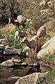
Bighorns in Anza-Borrego
-
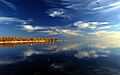
Salton Sea
-
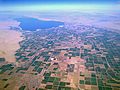
Aerial view of Imperial Valley and Salton Sea
-

Imperial County Courthouse in El Centro
-
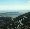
The Imperial Valley from the highway between Tijuana and Mexicali.
-
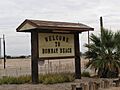
Bombay Beach sign along Highway 111
-
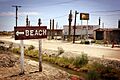
Salton Sea Beach
-

Fertilizing in the Imperial Valley, 1972. Photo by Charles O'Rear.


See also
 In Spanish: Valle de Imperial para niños
