
Algodones Dunes facts for kids
Quick facts for kids Algodones Dunes |
|
|---|---|

The dunes from space
|
|
| Location | Sonoran Desert, Imperial County, California, United States |
| Coordinates | 32°55′N 115°3′W / 32.917°N 115.050°W |
| Length | 45 miles (72 km) |
| Width | 6 miles (9.7 km) |
| Geology | Erg |
The Algodones Dunes are a huge area of sand dunes, like a giant sand playground! They are located in southeastern California, close to the borders of Arizona and Baja California, Mexico. This amazing sand field is about 45 miles (72 km) long and 6 miles (9.7 km) wide. It stretches in a line from northwest to southeast, which matches the direction the winds usually blow.
The name "Algodones Dunes" refers to the whole sandy area. However, the part managed by the Bureau of Land Management is called the Imperial Sand Dunes Recreation Area. People sometimes call it the Glamis Dunes. In 1966, the Imperial Sand Hills were named a National Natural Landmark. This means they are a very special natural place. The Algodones Dunes are divided into several parts, like Glamis, Gordon's Well, Buttercup, Midway, and Patton's Valley. The word algodones comes from Spanish and means "cotton plants," but no one knows why the dunes were given this name.
Contents
Where are the Algodones Dunes?

These dunes are found west of the Chocolate Mountains in Imperial County. Major roads like Interstate 8 and State Route 78 cross through them. State Route 78 even goes through an old train stop called Glamis on the eastern side of the dunes.
The northwestern end of the dunes is about 11 miles (18 km) east of Calipatria, California. The southeastern end is near Los Algodones in Mexico, about 6 miles (9.7 km) west of Yuma, Arizona. The dunes used to be connected to an even bigger sand area in Mexico called the Gran Desierto de Altar. Now, farmland separates them at the southern end. The only big human-made structures in the area are the All-American Canal, which crosses the southern part, and the Coachella Canal on the western edge.
How the Dunes Were Formed

The Colorado River used to flow through a very flat area. Because of this, the river's path changed a lot over time. Sometimes it flowed into the Gulf of California, like it mostly does today. Other times, it turned west towards the Salton Sink.
Each time the river flowed into the Salton Sink, a large freshwater lake called Lake Cahuilla formed. The last Lake Cahuilla covered much of the Imperial, Coachella, and Mexicali Valleys as late as 1450. Scientists believe the Algodones Dunes were formed from the sand left behind by Lake Cahuilla. The strong westerly and northwesterly winds carried this sand eastward from the old lake shore to where the dunes are now. The dunes are still slowly moving southeast by about one foot each year!
Dunes in History
The dunes have often been a challenge for people trying to travel through the area. Early travelers on foot often went south into Mexico to avoid them. In 1877, the Southern Pacific Railroad had to build its tracks north to go around the dunes.
However, in 1915, a man named Colonel Ed Fletcher built a wooden plank road right across the dunes. He wanted to prove that cars could cross them and connect San Diego with Yuma, Arizona. This plank road eventually became part of Interstate 8.
During World War II, the U.S. military used the dunes for desert warfare training. This area was part of a huge training ground called the California-Arizona Maneuver Area. People have been driving on the dunes for fun almost since cars first arrived. Some even say the first dune buggy was a changed Ford Model A tested here. After World War II, off-road driving became very popular when many surplus Jeeps became available to the public.
Fun on the Dunes Today


The Algodones Dunes are a very popular place for off-highway vehicle (OHV) use. Groups that want to protect the environment and groups that support OHV use have often disagreed about how much of the dunes should be open to vehicles.
Most of the dunes north of State Route 78 are closed to vehicles. This area is called the North Algodones Dunes Wilderness. The government protected these 25,818 acres (10,448 ha) in the 1980s and closed them to vehicles.
However, much of the area south of this road is still open for OHV fun. Even after some areas were closed in 2000, about 40% of the recreation area remained open. In 2014, a large part (about 40,000 acres) was reopened for vehicles. This makes it the largest sand dune area open for off-highway vehicles in the United States!
Many people love to drive their Motorcycles, sandrails, ATVs, and 4-wheel-drive vehicles across the dunes. You can also camp anywhere you like. On big winter holidays, as many as 150,000 people might visit in one weekend! All these visitors bring a lot of business to nearby towns like Brawley, California, Yuma, Arizona, and El Centro, California during the cooler months.
Dune Wildlife

The Algodones Dunes are a unique place for plants and animals. They are the largest dune ecosystem in the United States. This means many species of plants and animals live only here and nowhere else in the world!
One special plant is the perennial plant Peirson's milkvetch. It is a threatened species in the U.S. and an endangered species in California. This plant only grows in years when there is enough rain.
There are also dozens of insect species found only in the Algodones Dunes or nearby areas. For example, many types of scarab beetles, weevils, buprestid beetles, spider wasps, sand wasps, and andrenid bees live here. Scientists are still studying these unique insects to learn more about them.
Dunes in Movies
The Algodones Dunes have been used as a filming location for many movies and TV shows. Their sandy, desert look makes them perfect for scenes set in faraway lands.
Some famous movies filmed here include:
- Road to Morocco
- Flight of the Phoenix
- Tobruk
- Stargate
- Resident Evil: Extinction
- The Tatooine scenes in Return of the Jedi
The 1934 movie The Lost Patrol was also filmed here. You can even see the dunes in the opening scene of the old TV series Kung Fu.
Climate
The Algodones Dunes have a Hot desert climate. This means it's very hot and dry most of the year.
- wilderness.net: North Algodones Dunes Wilderness
Images for kids
-
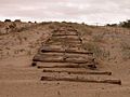
Remains of Old Plank Road in 2001

See also
 In Spanish: Dunas de los Algodones para niños
