Chocolate Mountains facts for kids
Quick facts for kids Chocolate Mountains |
|
|---|---|
 |
|
| Highest point | |
| Elevation | 877 m (2,877 ft) |
| Geography | |
| Country | United States |
| State | California |
| District | Imperial County |
| Range coordinates | 33°28′N 115°35′W / 33.467°N 115.583°W |
| Topo map | USGS Frink NE |
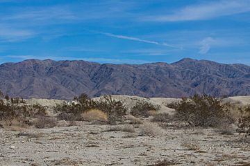
The Chocolate Mountains are a mountain range in Southern California. They are found in Imperial and Riverside counties. These mountains are part of the Colorado Desert.
The range stretches for over 60 miles (100 km) from northwest to southeast. You can find them east of the Salton Sea. They are also south and west of the Chuckwalla Mountains and the Colorado River. The Orocopia Mountains are to their northwest.
Contents
Exploring the Chocolate Mountains' Geography
The Chocolate Mountains form the northeast edge of the Salton Trough. They extend about 80 miles (130 km) southeast. This narrow range goes from the Orocopia Mountains to the Colorado River valley.
These mountains are about 30 miles (48 km) west of the Chocolate Mountains in Arizona. But the two ranges are not connected. The highest point is Mount Barrow, which is 2,475 feet (754 m) tall. The mountains help separate water flow for the Salton Watershed to the west.
Climate and Plant Life in the Mountains
The Chocolate Mountains get very little rain each year. They usually receive only 4 to 6 inches (100 to 150 mm) of rainfall. The main plants growing here are creosote bush and white bursage. The average yearly temperature is about 60°F (16°C) to 75°F (24°C).
Understanding the Chocolate Mountains' Geology
The mountains are made of very old rocks called Precambrian basement rocks. They also contain Orocopia Schist and Mesozoic granite.
These mountains might have formed when a small piece of land crashed into Southern California. This happened during the Late Cretaceous period. A thrust fault shows this collision. It pushed older rocks from the continental crust over the Orocopia Schist. The Orocopia Schist was made of ocean sediments and volcanic rocks.
Gold Mining History in the Range
In the 1800s, many small gold mines were active in these mountains. One mine, the Mesquite Mine, kept working into the 1900s. It was located to the east of the range.
A Look at the Chocolate Mountains' History
The Bradshaw Trail passed alongside these mountains. This was the first route for people from Europe and America to reach the Colorado River from Riverside, California.
Military Use of the Mountains
A large part of the Chocolate Mountains is used by the military. It is called the Chocolate Mountain Aerial Gunnery Range. The United States Navy and Marines use it for aerial and gunnery practice. Because of this, a big section of the Chocolate Mountains is closed to the public.
Exploring Wilderness Areas
At the southeast end of the Chocolate Mountains, there are two important wilderness areas. These are special places that protect nature.
Discovering Little Picacho Wilderness
The Little Picacho Wilderness covers 38,170 acres (154.5 km²). It protects unique geological features and animal homes. The Bureau of Land Management looks after this area.
This preserve includes the southern part of the Chocolate Mountains. The land here ranges from 200 to 1,500 feet (61 to 457 m) high. The landscape is very dramatic, with sharp spires and steep ridges. Small valleys lead into sandy, tree-lined washes. The slopes and plains have no plants. Instead, they are covered with a "desert pavement" of angular rocks. These rocks are rusty orange and brown. They stand out against the nearly white bottoms of the washes. This area is also known as the Little Picacho Peak Wilderness.
Exploring Indian Pass Wilderness
The Indian Pass Wilderness is located to the north. It has 32,008 acres (129.5 km²) of open space. This area is a special part of the Chocolate Mountains. The range stretches from south-central Riverside County to the Colorado River.
Quartz Peak is the highest point in this wilderness, reaching 2,200 feet (671 m). The area has jagged peaks and spires. Twisting canyons cut through the mountains. These canyons carry water from rare desert rainstorms into several tree-lined washes. One wash goes through the middle of the wilderness. This is why the area is sometimes called "Julian Wash country."
Because it is close to the Colorado River and the Arizona Desert, you can find wildlife here that is not common in the California Desert. The Indian Pass Wilderness is managed by the Bureau of Land Management. It is about 50 miles (80 km) west of Brawley, California.
Wildlife in the Wilderness Areas
A group of about 25 desert bighorn sheep live in the wilderness area. You can also find "the Picacho feral horses" and wild burros. Important native animals like the endangered desert tortoise and spotted bat also live here.
See also
 In Spanish: Sierra del Chocolate para niños
 | Ernest Everett Just |
 | Mary Jackson |
 | Emmett Chappelle |
 | Marie Maynard Daly |


