Orocopia Mountains facts for kids
Quick facts for kids Orocopia Mountains |
|
|---|---|

Orocopia Mountains
|
|
| Highest point | |
| Elevation | 1,117 m (3,665 ft) |
| Geography | |
| Country | United States |
| State | California |
| District | Riverside County |
| Range coordinates | 33°34′00″N 115°46′33″W / 33.56667°N 115.77583°W |
| Topo map | USGS Orocopia Canyon |
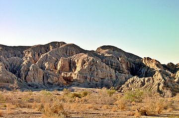
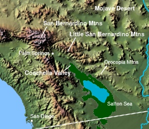
The Orocopia Mountains are a mountain range found in Riverside County, southern California, United States. They are located in the Colorado Desert, a part of the larger Sonoran Desert. These mountains stretch for about 18 miles from east to west. They are an important natural area, known for their unique geology and history. The Orocopia Mountains are east of the Coachella Valley and west of the Chuckwalla Mountains. They are also south of Interstate 10 and north of the Salton Sea.
Contents
Orocopia Mountains Wilderness Area
A large part of the Orocopia Mountains is a special protected area called the Orocopia Mountains Wilderness Area. This area is managed by the Bureau of Land Management (BLM). A wilderness area means the land is kept as natural as possible, with very few human changes. This helps protect the plants, animals, and natural beauty of the mountains. The Orocopia Mountains are part of the Colorado Desert section of the Sonoran Desert. Nearby is the Mecca Hills Wilderness Area to the north.
Plants and Animals of the Wilderness Area
The Orocopia Mountains Wilderness Area is home to interesting plants (flora) and animals (fauna). Some parts of the wilderness area have natural springs that create small oases. These oases are special because they are one of the few places where the California Fan Palm (Washingtonia filifera) grows naturally. This is the only type of palm tree that is native to California.
History of the Orocopia Mountains
The Orocopia Mountains have a rich history. An old route called the Bradshaw Trail passed through these mountains. This trail was the first known path that connected Riverside, California to the Colorado River. It was an important route for travelers and trade a long time ago.
Geology and Earth's Movements
The amazing and varied landscape of the Orocopia Mountains was mostly shaped by the movements of the nearby San Andreas Fault. This fault is a very long crack in the Earth's crust. Over thousands of years, the ground has moved along this fault, creating the mountains and valleys we see today.
One special rock found here is called the Orocopia schist. This type of rock is also found over 250 kilometers (about 155 miles) away in the San Gabriel Mountains. Scientists noticed that these rocks are very similar. This similarity helped them understand how much the San Andreas Fault has moved over time. It showed them that the land on one side of the fault has shifted a great distance from the land on the other side.
Astronaut Training for Moon Missions
The Orocopia Mountains have many different types of rocks and landforms. Because of this, they were used as a training ground for astronauts! Caltech Professor of Geology, Leon T. Silver, brought astronauts here to teach them about geology. This training helped them prepare for the NASA Project Apollo missions to the Moon. Learning about rocks and landforms in the Orocopia Mountains helped the astronauts know what to look for and how to collect samples when they landed on the Moon.
Astronauts who trained in the Orocopia Mountains included:
- Apollo 13 Crew Training: September 1969: Astronauts Lovell, Haise, and Swigert
- Apollo 15 Crew Training: June 1970: Astronauts Scott, Irwin, and Worden
- Apollo 16 Crew Training: April 1972: Astronauts Young, Mattingly, and Duke
- Apollo 17 Crew Training: December 1972: Astronauts Cernan, Evans, and Schmitt
See also
 In Spanish: Sierra de Orocopia para niños
 | Lonnie Johnson |
 | Granville Woods |
 | Lewis Howard Latimer |
 | James West |


