
San Gabriel Mountains facts for kids
Quick facts for kids San Gabriel Mountains |
|
|---|---|

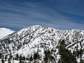
Summits in the eastern San Gabriel Mountains, Angeles National Forest, San Bernardino County, California. The main peaks are: Telegraph Peak 8,985 feet (2,739 m) (left), Cucamonga Peak, 8,859 feet (2,700 m) (center), and Ontario Peak 8,693 feet (2,650 m) (center right), as seen from Baldy Bowl on Mount Baldy.
|
|
| Highest point | |
| Peak | Mount San Antonio |
| Elevation | 10,069 ft (3,069 m) |
| Dimensions | |
| Length | 68.4 mi (110.1 km) |
| Width | 22.5 mi (36.2 km) |
| Area | 970 sq mi (2,500 km2) |
| Geography | |
 |
|
| Country | United States |
The San Gabriel Mountains are a group of mountains in California, USA. They are found in northern Los Angeles County and western San Bernardino County. These mountains are part of the Transverse Ranges. They sit between the busy Los Angeles Basin and the dry Mojave Desert.
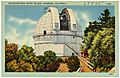
The highest point in the range is Mount San Antonio. People often call it Mt. Baldy. Another important peak is Mount Wilson. It is famous for the Mount Wilson Observatory. This observatory is open for people to visit. On October 10, 2014, President Barack Obama made part of the area a special place. It is now called the San Gabriel Mountains National Monument.
Contents
Exploring the San Gabriel Mountains
The San Gabriel Mountains have many rolling peaks. They are generally rugged and hard to travel through. The mountains are made of large blocks of rock. These blocks were pushed up by powerful forces in the Earth. This happened millions of years ago. Rivers and streams have since cut many deep canyons into the mountains.
Where are the San Gabriels?
The highest point is Mount San Antonio, also known as Mount Baldy. It stands at 10,069 feet (3,069 m) tall. The mountains stretch from the Cajon Pass in the east. Here, they meet the San Bernardino Mountains. They go west to the Santa Susana Mountains near Newhall Pass.
South of Santa Clarita, the mountains rise sharply. They reach about 4,000 feet (1,200 m) high. Canyons like Pacoima and Big Tujunga cut through them. These canyons carry water into the San Fernando Valley. Little Tujunga Canyon Road connects the San Fernando Valley to the Santa Clara River valley.
Southeast of Big Tujunga Canyon, the mountains get taller. Mount Wilson is a notable peak here. It is 5,710 feet (1,740 m) high. Further north, the main part of the San Gabriels forms a long arc. This arc is about 30 miles (48 km) long. It includes most of the highest peaks. Some of these are Waterman Mountain, Mount Islip, and Mount Baden-Powell.
On the north side, the mountains slope down to the Mojave Desert. This slope is much gentler than the steep southern side. The Angeles Crest Highway is a main road here. It runs from west to east across the mountains. Creeks like Little Rock and Big Rock flow north. They form large fan-shaped areas as they reach the desert.
East of San Antonio Canyon, the mountains get lower. The highest peaks in this area are in the south. They rise above cities like Claremont and Upland. Important peaks here include Telegraph Peak and Cucamonga Peak. The range ends at Cajon Pass. Beyond this pass are the even taller San Bernardino Mountains.

Cities and Towns Nearby
The San Gabriel Mountains are bordered by the Antelope Valley and Mojave Desert to the north. To the south, they are next to many communities of Greater Los Angeles. The south side of the range is almost always busy with cities. These include Pasadena, Azusa, and Rancho Cucamonga.
The north side of the mountains is less crowded. It includes the city of Palmdale. Smaller towns like Acton and Wrightwood are also found here. At the west end of the range is the city of Santa Clarita.
Water in the Mountains
Melting snow and rain create the largest river in the San Gabriels. This is the San Gabriel River. It has two main parts: the West Fork and the East Fork. The West Fork flows east for 14 miles (23 km). The East Fork flows south and west for 18 miles (29 km).
The two parts meet at San Gabriel Reservoir. From there, the river flows south. It cuts through the mountains near Azusa. Finally, it empties into the Pacific Ocean near Seal Beach.
Tallest Peaks

Here are some of the tallest peaks in the San Gabriel Mountains:
- Mount San Antonio (Mount Baldy), 10,064 ft (3,068 m)
- Pine Mountain, 9,648 ft (2,941 m)
- Dawson Peak, 9,575 ft (2,918 m)
- Mount Harwood, 9,552 ft (2,911 m)
- Mount Baden-Powell, 9,399 ft (2,865 m)
- Throop Peak, 9,138 ft (2,785 m)
- Mount Burnham, 9,001 ft (2,744 m)
- Telegraph Peak, 8,985 ft (2,739 m)
- Cucamonga Peak, 8,859 ft (2,700 m)
- Ontario Peak, 8,693 ft (2,650 m)
- Mount Lewis, 8,396 ft (2,559 m)
- Timber Mountain, 8,307 ft (2,532 m)
- Mount Islip, 8,250 ft (2,510 m)
- Mount Williamson, 8,214 ft (2,504 m)
- Waterman Mountain, 8,038 ft (2,450 m)
- Iron Mountain, 8,007 ft (2,441 m)
- South Mount Hawkins, 7,783 ft (2,372 m)
- Pacifico Mountain, 7,124 ft (2,171 m)
- Mount Gleason, 6,502 ft (1,982 m)
- Strawberry Peak, 6,164 ft (1,879 m)
- San Gabriel Peak, 6,162 ft (1,878 m)
- Mount Disappointment, 5,960 ft (1,820 m)
- Mount Lawlor, 5,961 ft (1,817 m)
- Vetter Mountain, 5,911 ft (1,802 m)
- Rattlesnake Peak, 5,826 ft (1,776 m)
- Mount Wilson, 5,710 ft (1,740 m)
- Mount Lowe, 5,703 ft (1,738 m)
- Josephine Peak, 5,561 ft (1,695 m)
- Condor Peak, 5,440 ft (1,660 m)
- Monrovia Peak, 5,409 ft (1,649 m)
- Rankin Peak, 5,269 ft (1,606 m)
- Smith Mountain, 5,111 ft (1,558 m)
- Mount Lukens, 5,074 ft (1,547 m)
- Magic Mountain, 4,864 ft (1,483 m)
- Mendenhall Peak, 4,636 ft (1,413 m)
- Clamshell Peak, 4,360 ft (1,330 m)
- Los Piñetos Peak 3,560 ft (1,090 m)
- Kagel Mountain, 3,537 ft (1,078 m)
- Potato Mountain, 3,422 ft (1,043 m)
- Echo Mountain, 3,210 ft (980 m)
Weather in the Mountains
The weather in the San Gabriel Mountains changes with how high up you are. Summers are mostly dry, but sometimes have thunderstorms. Winters are cold and wet. Snow can fall above 4,000 ft (1,200 m) from November to April. It is most common from December to March.
The southern side of the mountains gets more rain than the northern desert side. The most rain falls in the central and eastern parts of the range. Rain amounts can change a lot each year. Very wet years, like during El Nino, can bring over 70 in (1,800 mm) of rain. Heavy rain can cause floods in towns at the base of the mountains. This is especially true after wildfires.
The air above 5,000 ft (1,500 m) is usually clear. This is why the large telescope at Mount Wilson was built there. However, light from the cities below has made it harder to use the telescopes recently.
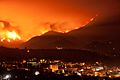
Wildfires in the San Gabriels
Wildfires happen often in the San Gabriel Mountains. These fires are often made worse by dry Santa Ana winds in summer and fall. Some big fires include the 2009 Station Fire and the 2020 Bobcat Fire.
How the Mountains Formed
The San Gabriel Mountains are mostly made of granite and other changed rocks. These rocks were pushed up over millions of years. This happened as huge pieces of the Earth's crust moved. The mountains are still rising today.
The speed at which the mountains are rising and wearing away is very fast. This is especially true in the eastern San Gabriel Mountains. This area is where the San Andreas and San Jacinto faults meet. Wildfires have also made the land wear away faster in recent years. Scientists are studying if the plants and soil can recover after so many fires.
Plants and Animals
The San Gabriel Mountains have different types of forests. Some areas have pine, fir, and cedar trees. Others have oak trees. These forests are common above 5,000 feet (1,500 m) where it rains more. In wetter spots, you can also find madrone and bay laurel trees. Ferns are also common.
Along streams, you can see willow, alder, and cottonwood trees. These grow even at lower elevations. Chaparral is a type of dense shrub and brush. It covers areas where there are no tall trees. Chaparral can grow back quickly after fires. A special type of Leather Oak tree grows only in these mountains.
Larger animals in the mountains include California mule deer and California black bear. You might also see San Pedro Martir coyotes. Mountain lions are rarely seen. Smaller animals like raccoons, opossums, and bobcats are more common. Rattlesnakes are often seen on hiking trails.
Sadly, the critically endangered yellow-legged frogs have almost disappeared. This is because their homes have been lost. Also, new animals like trout were brought in. These trout eat the frog tadpoles, which hurt the frog population.
Getting Around the Mountains

The main road through the San Gabriel Mountains is the Angeles Crest Highway. This is also known as State Route 2. It starts in La Cañada Flintridge. It ends near Wrightwood. Parts of this highway close in winter due to falling rocks and snow.
Another important road is Angeles Forest Highway. It connects to the Angeles Crest Highway. This road helps people get to the central part of the forest. It also provides easy access to the Antelope Valley. This road is kept in better condition and stays open more often in winter.
State Route 39 used to connect Azusa to the Angeles Crest Highway. However, landslides damaged it in 1978 and 2005. This road is currently closed to the public. Reopening Highway 39 would make it much faster to reach places like the Waterman Ski Area. In 2016, officials started looking into plans to reopen the road again.
Fun Things to Do
In winter, many people enjoy snowboarding and skiing. Popular spots are Mountain High and Mt. Baldy. Other resorts like Mount Waterman are not open as often due to less snow.
In summer, people like to go canyoneering, hiking, and camping. Picnics are also popular. Sometimes, hikers get lost or stuck. Rescue teams often help them. The Pacific Crest Trail also runs along the mountain ridge.
Many climbers visit in winter to climb snow and ice routes. Baldy Bowl is a very popular climbing spot. There are many other routes for different skill levels.
Rock climbing is not as common here as in other areas. This is because the rocks in the San Gabriels can be loose. The constant movement of the Earth's crust breaks up the rock. This makes it less suitable for climbing.
The Angeles National Forest Fire Lookout Association helps maintain fire lookout towers. They have rebuilt and operate Vetter Mountain Lookout and Slide Mountain Lookout. They are also rebuilding South Mount Hawkins Lookout.

Nearby Mountains
- San Rafael Hills
- Santa Ana Mountains
- Verdugo Mountains
- San Bernardino Mountains
- Santa Susana Mountains
- Santa Monica Mountains
- Sierra Pelona Mountains
- Topatopa Mountains
- Tehachapi Mountains
Images for kids
-
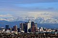
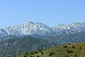
San Gabriel Mountains east of downtown Los Angeles
-
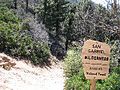
San Gabriel Wilderness
-
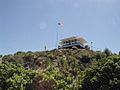
Vetter Lookout
-
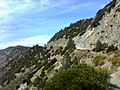
Highway 2 through the San Gabriel Mountains
-
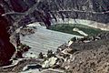
Big Dalton Dam near full capacity
-
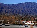
Monrovia and the San Gabriel Mountains
-
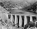
San Gabriel Dam
-
San Gabriel Mountains from Cajon Pass
-
Snowpack
-
Wildfire
-
Mount Wilson Observatory
-
Angeles National Forest


.jpg)


.jpg)

See also
 In Spanish: Sierra de San Gabriel para niños
