
Topatopa Mountains facts for kids
Quick facts for kids Topatopa Mountains |
|
|---|---|

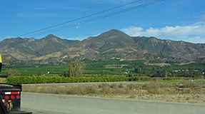
Northeastern face as viewed from Santa Clarita
|
|
| Highest point | |
| Peak | Hines Peak |
| Elevation | 6,716 ft (2,047 m) |
| Geography | |
| Country | United States |
| Parent range | Transverse Ranges |
The Topatopa Mountains are a mountain range located in Ventura County, California. You can find them north of cities like Ojai, Santa Paula, and Fillmore. These mountains are part of a larger group called the Transverse Ranges in Southern California.
Contents
Geography of the Topatopa Mountains
The Topatopa Mountains stretch out from east to west. They are located east of the Sierra Madre Mountains and west of the Sierra Pelona Mountains. To the south of the range is the Santa Clara River Valley. Many small streams flow from the mountains into the Santa Clara River.
The highest point in the range is Hines Peak, which stands at about 6,716 feet (2,047 meters) tall. This peak is about six miles north of Thomas Aquinas College. During winter, it often snows on the higher parts of these mountains.
Lake Piru is the only large lake or reservoir found within the Topatopa Mountains. It's an important water source in the area.
Nature and Wildlife
The Topatopa Mountains are part of the huge Los Padres National Forest. This forest helps protect the natural environment. Inside these mountains, you'll find the Sespe Wilderness Area and the Sespe Condor Sanctuary. These special areas are very important for the endangered California condor. These huge birds call the Topatopa Mountains their home.
The plants and trees here are part of what's called the California montane chaparral and woodlands ecoregion. This means you'll see many shrubs, small trees, and woodlands that are good at living in dry, hilly areas. Sespe Creek flows through the mountains, creating a deep canyon called Sespe Gorge. Along the creek, there are special areas called Riparian habitats with willows and other trees that like water.
-
View from Fillmore of the Topatopa Mountains, with San Cayetano Mountain at center.
-
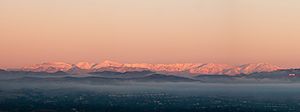
The southeastern face of the Topatopa Mountains as seen from Santa Clarita Valley.


Tallest Peaks
Here are some of the highest peaks in the Topatopa Mountains:
- Hines Peak - 6,716 feet (2,047 meters)
- Cobblestone Mountain - 6,699 feet (2,041 meters)
- Topatopa Bluff - 6,367 feet (1,941 meters)
- Chief Peak - 5,560+ feet (1,695+ meters)
- Santa Paula Peak - 4,957 feet (1,511 meters)
- Nordhoff Peak - 4,485 feet (1,367 meters)
Nearby Mountain Ranges
The Topatopa Mountains are surrounded by other mountain ranges that are also part of the Transverse Ranges system:
- San Emigdio Mountains - to the north
- Pine Mountain Ridge - to the north and northwest
- Sulphur Mountains (California) - northwest, across the Ojai Valley
- Sierra Madre Mountains - to the west
- Santa Ynez Mountains - to the southwest
- Santa Susana Mountains - to the southeast
- Sierra Pelona Mountains - to the east
- Tehachapi Mountains - to the northeast
