Sierra Pelona Ridge facts for kids
Quick facts for kids Sierra Pelona |
|
|---|---|
| Sierra Pelona Mountains | |

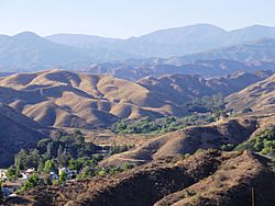
View from Santa Clarita
|
|
| Highest point | |
| Peak | Burnt Peak |
| Elevation | 5,791 ft (1,765 m) |
| Geography | |
| Location | Los Angeles County, California, U.S. |
| Parent range | Transverse Ranges |
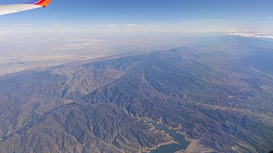
The Sierra Pelona (say: see-AIR-uh peh-LOH-nuh) is a cool mountain range in Southern California. It's also called the Sierra Pelona Ridge or Sierra Pelona Mountains. These mountains are in the northwest part of Los Angeles County. To the north, they are next to the famous San Andreas Fault. The whole area is part of the Angeles National Forest, which is a big protected natural space.
Contents
Where are the Sierra Pelona Mountains?
The Sierra Pelona Mountains are located northwest of the San Gabriel Mountains. A wide area called Soledad Canyon separates these two mountain ranges. To the south of the Sierra Pelonas is the Santa Clarita Valley. To the north, the San Andreas Fault separates them from the Antelope Valley and the Mojave Desert.
Near the mountains, you can find interesting places like Vasquez Rocks. These unique rock formations were pushed up by the San Andreas Fault. The Tejon Pass is another important spot. It separates the Sierra Pelonas from the San Emigdios and Tehachapis near the towns of Gorman and Lebec.
Inside the Sierra Pelona Mountains, there are small towns and communities. These include Neenach, Three Points, Lake Hughes, Elizabeth Lake, Acton, Agua Dulce, and Green Valley. Larger cities like Santa Clarita, Palmdale, and Lancaster are located at the base of the mountains.
What is the Climate Like?
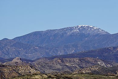
The climate in the Sierra Pelona Mountains is a Mediterranean climate. This means summers are usually dry, though you might see a thunderstorm now and then. Winters are colder and wetter. It doesn't snow very often because these mountains are not super high. Only the tallest peaks usually get snow during the winter months.
What Plants and Animals Live Here?
Most of the Sierra Pelona Ridge is covered in plants typical of the California montane chaparral and woodlands ecoregion. This means you'll find lots of short grasses, scrub oak trees, yucca plants, and other chaparral shrubs. The northeastern side of the mountains gradually slopes down into the Antelope Valley near Palmdale.
The ridge can have wildfires, especially in the summer and fall. This happens more often when strong, dry winds called Santa Ana winds blow in from the Antelope Valley.
Water Sources in the Mountains
The Sierra Pelona Mountains are important for water. Three main streams and many smaller ones drain the ridge. These streams flow into the Santa Clara River. The biggest ones are Castaic Creek, San Francisquito Creek, and Bouquet Creek.
You can also find three special lakes called sag ponds in a narrow valley that separates the mountains from the Antelope Valley. These lakes are Hughes Lake, Munz Lakes, and Elizabeth Lake.
A Look at Human History
Native American People
Long ago, Native American groups lived in the Sierra Pelona and Santa Susana Mountains. These included the Tataviam and Serrano people. They traded with other groups like the Tongva and Chumash who lived to the south and west. Later, during the Spanish colonization of the Americas, these Native people were moved from their traditional homes.
Travel Routes in the Past
The San Francisquito Canyon runs through the mountains from north to south. In the 18th and 19th centuries, this canyon was a very important path for wagons. It connected the Antelope and San Fernando Valleys. This route went over San Francisquito Pass and was part of the El Camino Viejo. This was an alternative land route to the famous El Camino Real, used to reach northern Spanish and Mexican areas of Alta California. It was also part of the Butterfield Overland Mail route, which delivered mail across the country.
Modern Roads and Water Systems
In the 20th century, Southern California grew very quickly. To help with this growth, new roads and water systems were built. The Ridge Route, a famous two-lane highway, was finished in 1915. It ran along the western side of the mountains and connected Los Angeles to the rest of California. Later, a new highway called the Ridge Route Alternate (US 99) replaced it in 1930. Even later, Interstate 5 was completed in 1971, making travel even faster.
To bring water to the growing region, the Los Angeles Aqueduct was built. Five different reservoirs were also constructed: Castaic Lake, Bouquet Reservoir, Drinkwater Reservoir, and Dry Canyon Reservoir. The St. Francis Reservoir was another important water source, but it was later drained and destroyed.
Tallest Peaks in the Sierra Pelona Mountains
Here are some of the highest points in the Sierra Pelona Mountains:
- Burnt Peak: 5,788 feet (1,764 meters)
- Liebre Mountain: 5,760+ feet (1,756+ meters)
- Sawmill Mountain: 5,514 feet (1,681 meters)
- Jupiter Mountain: 4,498 feet (1,371 meters)
- Redrock Mountain (benchmark): 3,991 feet (1,216 meters)
Nearby Landforms
The Sierra Pelona Mountains are surrounded by other interesting landforms:
- Tehachapi Mountains - to the north
- San Emigdio Mountains - to the northwest
- Topatopa Mountains - to the west
- Santa Susana Mountains - to the southwest
- San Gabriel Mountains - to the east
- Santa Clarita Valley - to the south
- Soledad Canyon - to the southeast
- Antelope Valley (part of the Mojave Desert) - to the east-northeast
See also
 In Spanish: Sierra Pelona para niños
 | Aurelia Browder |
 | Nannie Helen Burroughs |
 | Michelle Alexander |


