kids encyclopedia robot

Palmdale, California facts for kids

Kids Encyclopedia Facts
Quick facts for kids
Palmdale, California
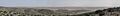
Palmdale, looking southeast toward the Antelope Valley Freeway and the San Gabriel Mountains
Flag of Palmdale, California
Flag
Official seal of Palmdale, California
Seal
Motto(s): 
"A Place to Call Home"
Location of Palmdale in Los Angeles County, California
Palmdale, California is located in the Los Angeles metropolitan area
Palmdale, California
Location in the Los Angeles metropolitan area
Palmdale, California is located in California
Palmdale, California
Location in California
Palmdale, California is located in the United States
Palmdale, California
Location in the United States
Country  United States
State  California
County Los Angeles
Established 1886
Incorporated August 24, 1962
Government
 • Type Council–manager
 • Body City council:
  • Steve Hofbauer (mayor)
  • Austin Bishop, Dist-1
  • Richard J. Loa, Dist-2
  • Laura Bettencourt, Dist-3
  • Juan Carillo, Dist-4
Area
 • City 106.32 sq mi (275.37 km2)
 • Land 106.08 sq mi (274.74 km2)
 • Water 0.24 sq mi (0.63 km2)  0.24%
Elevation
2,657 ft (810 m)
Population
 (2010)
 • City 152,750
 • Estimate 
(2019)
155,079
 • Rank 6th in Los Angeles County
35th in California
 • Density 1,461.93/sq mi (564.45/km2)
 • Metro
12,828,837
Demonym(s) Palmdalite
Time zone UTC−8 (Pacific Time Zone)
 • Summer (DST) UTC−7 (PDT)
ZIP Codes
93550–93552, 93590–93591, 93599
Area code 661
FIPS code 06-55156
GNIS feature IDs 1652769, 2411359

Palmdale is a city in northern Los Angeles County in the U.S. state of California. The city lies in the Antelope Valley region of Southern California. The San Gabriel Mountains separate Palmdale from the Los Angeles Basin to the south.

On August 24, 1962, Palmdale became the first community in the Antelope Valley to incorporate. Forty-seven years later, in November 2009, voters approved making it a charter city. Palmdale's population was 152,750 at the 2010 census, up from 116,670 at the 2000 census. Palmdale is the 35th most populous city in California. Together with its immediate northern neighbor, the city of Lancaster, the Palmdale/Lancaster urban area had an estimated population of 513,547 as of 2013.

History

Palmdale CA and Antelope Valley and Environs Landsat7
This satellite image, looking toward the west, shows the Palmdale / Antelope Valley area in relation to Los Angeles with the San Gabriel Mountains separating them.

"Palmenthal", the first European settlement within the limits of Palmdale, was established as a village on April 20, 1886, by westward Lutheran travelers from the American Midwest, mostly of German and Swiss descent. According to area folklore, the travelers had been told they would know they were close to the ocean when they saw palm trees. Never actually having seen palm trees before, they mistook the local Joshua trees for palms and so named their settlement after them. (Palmenthal is German for Palms Valley.) According to David L. Durham Joshua trees were sometimes called yucca palms at the time, which was the reason for the name. The village was officially established upon the arrival of a post office on June 17, 1888.

By the 1890s (soon after the last of the indigenous antelopes, which the valley was named after, had died) farming families continued to migrate to Palmenthal and nearby Harold to grow grain and fruit. However, most of these settlers were unfamiliar with farming in a desert climate, so when the drought years occurred, most abandoned their settlement. By 1899, only one family was left in the original village. The rest of the settlers, including the post office, moved closer to the Southern Pacific railroad tracks. This new community was renamed Palmdale and was located where the present day civic center is. A railroad station was built along the tracks there. This railroad was operated by Southern Pacific and traveled between Los Angeles and San Francisco. The Wells Fargo stagecoach line that ran between San Francisco and New Orleans stopped there as well. The only remaining pieces of evidence of the original settlements of Palmenthal and Harold are the old Palmdale Pioneer cemetery located on the northeast corner of Avenue S and 20th Street East, recently acquired and restored by the city as part of a future historical park, and the old schoolhouse now relocated to McAdam Park.

As the population of Palmdale began to increase after relocation, water became scarce, until November 5, 1913 when the California – Los Angeles Aqueduct system was completed finally by William Mulholland, bringing water from the Owens Valley into Los Angeles County. During this period, crops of apples, pears and alfalfa became plentiful.

In 1915, Palmdale's first newspaper, the Palmdale Post, was published. Today it is called the Antelope Valley Press.

In 1921, the first major link between Palmdale and Los Angeles was completed, Mint Canyon/Lancaster Road, later designated U.S. Route 6. Completion of this road caused the local agricultural industry to flourish and was the first major step towards defining the metropolis that exists today. Presently this road is known as Sierra Highway.

In 1924, the Little Rock Dam and the Harold Reservoir, present day Lake Palmdale, were constructed to assist the agricultural industry and have enough water to serve the growing communities.

Lake Palmdale-kmf
Picture of Lake Palmdale with the California Aqueduct in the foreground.

Agriculture continued to be the foremost industry for Palmdale and its northern neighbor Lancaster until the outbreak of World War II. In 1933, the United States government established Muroc Air Base (from an original founder's name, Effie Corum, spelled backwards) six miles (10 km) north of Lancaster in Kern County, now known as Edwards Air Force Base. They also bought Palmdale Airport in 1952 and established an aerospace development and testing facility called United States Air Force Plant 42. One year later, in 1953, Lockheed established a facility at the airport. After this point in time, the aerospace industry took over as the primary local source of employment, where it has remained ever since. Today the city is even referred to as the "Aerospace Capital of America" because of its rich heritage in being the home of many of the aircraft used in the United States military.

In August 1956 an unpiloted out of control Navy drone flew over Palmdale while Air Force Interceptor aircraft tried to shoot it down with unguided rockets. Many rockets landed in and around the city starting fires and damaging property.

In 1957, Palmdale's first high school, Palmdale High School, was established, making it easier for youths to not have to travel to Antelope Valley High School in nearby Lancaster. In 1989, Palmdale's second high school was established, Highland High School, due to the fast growing population within the city. This was followed by a third high school established in 2003, Knight High School

Incorporation

In August 1962, the township of Palmdale officially became the city of Palmdale with the incorporation of 2 square miles (5 km2) of land around the present day civic center.

In 1964, the Antelope Valley Freeway, or State Highway 14, was completed as a link between Palmdale and Los Angeles. The freeway at this time ran all the way to present day Technology Drive. It was at this time that talk about the future Palmdale Intercontinental Airport was seen as the way of the future. By 1965 the new city had annexed an additional 20 square miles (52 km2) of land and industry was thriving. Talk of the future commercial airport had many investors buying up large quantities of land.

Palmdale Freeway
Antelope Valley Freeway looking southbound in downtown Palmdale on a day with sparse traffic.

In 1970, the city of Los Angeles went forward with buying 17,750 acres (71.8 km2) of land east of the city for its proposed intercontinental commercial airport. However, the United States Air Force desired to put a hold on the construction of this new facility until the existing airport reached its commercial capacity. So under a joint use agreement with the military, the Los Angeles Department of Airports, now called Los Angeles World Airports, built a 9,000 square foot (800 m²) terminal on leased land that opened in 1971, creating present day LA/Palmdale Regional Airport which the City of Palmdale has taken control of in an effort to establish reliable air service in the region.

By 1974, the Antelope Valley Freeway construction ended at the southern border of Mojave in Kern County. In 1977, Palmdale built its first municipal building, the Palmdale City Library. This was the same year that its northern neighbor Lancaster incorporated itself into a city. Since the 1920s, Lancaster had been the much larger and principal community of the Antelope Valley, as well as the rest of California's Mojave Desert.

Central Palmdale
Central Palmdale looking north along 10th Street West toward Rancho Vista Blvd.

The 1980s and 1990s were the decades that really started to define the two Antelope Valley cities. Affordable housing in the area caused a dramatic spike in the population. The city, like its northern neighbor Lancaster, became a bedroom community for those employed in Los Angeles. In 1980, Palmdale's population was 12,227.

By 1990, it had grown to 68,842. During that same year the Antelope Valley Mall opened at Avenue P (present day Rancho Vista Blvd.) and 10th Street West. In 1991, the Palmdale Auto Center complex opened. In 2000, the city's population was 116,670. With over 150,000 residents today, the City Planning Commission continues to attempt a form of managed growth in the early part of 21st century. The recent subprime mortgage crisis has affected the city with a tremendous number of foreclosures. However, even with the high number of foreclosures, the city remains the fastest growing city in Los Angeles County, and the fastest growing large city in the State of California.

Over the last 25 years this city has consistently been ranked in the top 25 fastest growing cities in the United States (based on percentage change). As of the 2010 census, the population was 152,750, the sixth most populous in Los Angeles County. With 106 square miles (275 km2) of land in its incorporated boundaries, the city is the second largest city in Los Angeles County by land area, 6th largest in California by land area, and in the top 100 largest cities in the United States in land area. Palmdale is also one of the largest cities in the United States that is not currently served by either an Interstate Freeway or a U.S. Highway. Sierra Highway was at one time labeled as U.S. Highway 6 until the State of California truncated it at Bishop.

Palmdale Regional Medical Center, a first-class medical facility opened in 2010, includes an emergency department, a helipad, medical office towers, and a senior housing complex. A new multimodal transportation center, serving local and commuter bus and train services, opened in 2005. A voter-initiated and -approved tax has funded major park and recreation expansions, including the Palmdale Amphitheater (capacity 10,000), two new pools, other recreation buildings, satellite library and Dry Town Water Park. Downtown revitalization includes hundreds of new senior housing units, a new senior center, and expanded open space. A sheriff station opened in July 2006, the largest in Los Angeles County. Two additional fire stations have been built, one on the east side of town and one on the west side of town.

Geography

Palmdale is located in Los Angeles County, and the urbanized centers of Palmdale and Los Angeles are separated by the San Gabriel mountain range, which is about 40 miles (64 km) wide. This range forms the southern edge of the Antelope Valley portion of the Mojave Desert. Palmdale is the second largest city in the Antelope Valley, and the fifth largest city overall in the Mojave Desert by population, after Las Vegas, Henderson, North Las Vegas and Lancaster. Palmdale is part of a twin city complex with its immediate northern neighbor Lancaster and together they are the principal cities within the Antelope Valley region and California's High Desert.

Downtown Palmdale is located at 34°34′46″N 118°07′00″W / 34.57944°N 118.11667°W / 34.57944; -118.11667, at an elevation of 2,655 feet (809 m) above sea level.

According to the United States Census Bureau the city has a total area of 106.2 square miles (275 km2), of which, 106.0 square miles (275 km2) of it is land and 0.3 square miles (0.78 km2) of it is water (including man-made Lake Palmdale, the most visible and scenic part of the municipal water supply system) . The total area is 0.24% water.

The city lies in close proximity to the San Andreas Fault, making it, like many other regions of California, prone to strong earthquakes. This fault cuts across the Antelope Valley Freeway just north of the Avenue S off-ramp; running westward along the old Butterfield Stage Line (now Elizabeth Lake Road) into Leona Valley.

Palmdale snow w
Looking south from the hills near Tierra Subida Avenue, late January snow can be seen at the higher elevations.

Climate

Palmdale is located in the High Desert, where the summers are very hot and dry, and winters are cool and windy with snow fall possible. Palmdale has over 300 days of sunshine per year. The same weather pattern that brings the marine layer stratus and afternoon sea breeze to the Los Angeles Basin brings gusty winds to Palmdale, especially near the foothills on the south side. Except during Santa Ana (northeast) wind events (usually fall and winter), gusty southwest winds blow over Palmdale almost every afternoon and evening all year round. The wind is so reliable that wind turbines are used to generate electricity.

Winter: Relatively chilly to cold, wet and windy. Winter days are somewhat mild, but winter nights can be cold. Temperatures have gone into the single-digits at times. The wind chill factor can sometimes be below zero. This is Palmdale's rainy season and is prone to flash flooding during this time. On occasion, it will snow, sometimes with several inches of accumulation. Average day time highs are in the upper 50s(F) to low 60s(F), while winter nights are usually in the 30s(F) and as low as the 20s(F).

Spring: Moderate temperatures. Still occasionally wet. Very windy. Transitional period from winter to summer temperatures is very short. Average daytime highs are in the upper 70s(F) to low 80s(F) while being in the 40s(F) to low 50s(F) overnight.

Summer: Very hot, dry heat with little or no precipitation. Temperatures frequently soar into triple-digits. However, the high desert where Palmdale is located, allows for the temperatures to cool down somewhat at night, unlike the low desert cities such as Palm Springs. Average day time highs are in the upper 90s(F) while dropping into the mid to upper 70s(F) after midnight. Local electrical bills spike during this period with air-conditioning units running day and night, until early October. Despite the hot temperature, it is very common to experience "summer storms" in which temperatures are consistent but there is heavy rain and thunderstorms.

Fall: Moderate temperatures with little or no precipitation. Transitional period from summer to winter temperatures is very short. As a result, the deciduous trees in Palmdale will lose their leaves very rapidly, seemingly overnight, with a short color change. Average day time highs are in the upper 70s(F) and low 80s(F) while dropping into the mid 40s(F) to mid 50s(F) overnight.

Climate data for Palmdale, California
Month Jan Feb Mar Apr May Jun Jul Aug Sep Oct Nov Dec Year
Record high °F (°C) 81
(27)
84
(29)
91
(33)
98
(37)
107
(42)
112
(44)
113
(45)
112
(44)
111
(44)
105
(41)
93
(34)
84
(29)
113
(45)
Average high °F (°C) 59
(15)
63
(17)
68
(20)
75
(24)
83
(28)
91
(33)
97
(36)
97
(36)
91
(33)
80
(27)
67
(19)
59
(15)
81
(26)
Average low °F (°C) 34
(1)
37
(3)
40
(4)
45
(7)
53
(12)
60
(16)
66
(19)
65
(18)
59
(15)
50
(10)
39
(4)
33
(1)
48
(9)
Record low °F (°C) 4
(−14)
15
(−9)
14
(−10)
20
(−7)
28
(−2)
35
(2)
43
(6)
38
(3)
34
(1)
23
(−5)
14
(−10)
9
(−13)
4
(−14)
Average precipitation inches (cm) 1.6
(4.0)
1.7
(4.3)
1.4
(3.5)
0.3
(0.8)
0.2
(0.4)
0.1
(0.2)
0.1
(0.2)
0.1
(0.3)
0.2
(0.6)
0.2
(0.6)
0.4
(1.1)
1.1
(2.8)
7.4
(18.8)
Source: weather.com
  • Annual Average High Temperatures: 98 °F (summer) 59 °F (winter)
  • Annual Average Low Temperatures 66 °F (summer) 33 °F (winter)
  • Highest Recorded Temperature: 113 °F (1972, 2007)
  • Lowest Recorded Temperature: 6 °F (1963)
  • Warmest Month: July
  • Coolest Month: December
  • Highest Precipitation: February
  • Annual Precipitation: 7.40 inches

Demographics

Historical population
Census Pop.
1960 11,522
1970 8,511 −26.1%
1980 12,277 44.2%
1990 68,842 460.7%
2000 116,670 69.5%
2010 152,750 30.9%
2019 (est.) 155,079 1.5%
U.S. Decennial Census

The 2010 United States Census reported that Palmdale had a population of 152,750. The population density was 1,438.1 people per square mile (555.3/km2). The racial makeup of Palmdale was 74,901 (49.0%) White, (24.5% Non-Hispanic White), 22,677 (14.8%) African American, 1,316 (0.9%) Native American, 6,548 (4.3%) Asian (2.2% Filipino, 0.4% Indian, 0.4% Korean, 0.3% Chinese, 0.3% Vietnamese, 0.2% Japanese, 255 0.16% Cambodian, 168 0.11% Thai and 112 0.07% Pakistani), 335 (0.2%) Pacific Islander, 38,773 (25.4%) from other races, and 8,200 (5.4%) from two or more races. There were 83,097 Hispanic or Latino residents (54.4%). 38.1% of Palmdale residents are of Mexican ancestry; 6.2% Salvadoran; and 2.4% of Guatemalan heritage and 0.79% Honduran, 0.76% Puerto Rican, 0.69% Nicaraguan, 0.50% Cuban, 0.47% Colombian and Argentinian 0.34%. Spanish is spoken by 36.4% of the population and Tagalog by 1.3%. The most common ancestries are German 5.2%, Irish 4.1%, English 2.9%, Italian 2.7%, French 1.1%, Polish 1.0%, Norwegian 0.7%, Scottish 0.6%, Dutch 0.6%, Russian 0.6%, Swedish 0.5%, Belizean 0.4%, Armenian 0.4% and Danish, Welsh and Greek 0.3%.

The Census reported that 152,551 people (99.9% of the population) lived in households, 158 (0.1%) lived in non-institutionalized group quarters, and 41 (0%) were institutionalized.

There were 42,952 households, out of which 23,345 (54.4%) had children under the age of 18 living in them, 24,199 (56.3%) were opposite-sex married couples living together, 7,821 (18.2%) had a female householder with no husband present, 3,318 (7.7%) had a male householder with no wife present. There were 2,998 (7.0%) unmarried opposite-sex partnerships, and 316 (0.7%) same-sex married couples or partnerships. 5,828 households (13.6%) were made up of individuals, and 1,880 (4.4%) had someone living alone who was 65 years of age or older. The average household size was 3.55. There were 35,338 families (82.3% of all households); the average family size was 3.87.

The age distribution of the population included 50,514 people (33.1%) under the age of 18, 17,089 people (11.2%) aged 18 to 24, 40,077 people (26.2%) aged 25 to 44, 34,963 people (22.9%) aged 45 to 64, and 10,107 people (6.6%) who were 65 years of age or older. The median age was 29.7 years. For every 100 females, there were 95.3 males. For every 100 females age 18 and over, there were 91.3 males.

There were 46,544 housing units at an average density of 438.2 per square mile (169.2/km2), of which 29,167 (67.9%) were owner-occupied, and 13,785 (32.1%) were occupied by renters. The homeowner vacancy rate was 3.2%; the rental vacancy rate was 9.4%. 102,444 people (67.1% of the population) lived in owner-occupied housing units and 50,107 people (32.8%) lived in rental housing units.

During 2009–2013, Palmdale had a median household income of $53,922, with 21.2% of the population living below the federal poverty line.

26.30% are foreign born, 88.7% from Latin America. Most refugees in Palmdale came from Iran and Iraq.

The most common foreign born places of birth in Palmdale is Mexico 49.3% El Salvador 15.8%, Philippines 6.4%, Guatemala 6.2%, Korea 1.7%, Nicaragua 1.6% , Honduras 1.6%, Vietnam 1.5%, Iran 1.1% and Colombia 1.1%.

Changing demographics

Palmdale was mostly white up until the late 1970s. African Americans have moved to the city in significant numbers due to gentrification of Compton and South Los Angeles. Palmdale has a growing Latino and minority population.

Religion

37.0% of people are Catholic in Palmdale. 53.4% in the city are religious.

Panoramic photo of Palmdale from the west, taken March 2000

Transportation

According to the latest U.S. Census report released in September 2009, Palmdale has the longest average commute time in the United States at 41.5 minutes. This commute time exceeds that of even New York City. this is due to the majority of citizens commuting to nearby Santa Clarita and farther south to Los Angeles.

Airport

The LA/Palmdale Regional Airport/Air Force Plant 42 (PMD) has two runways, each over 2.25 miles (3.62 km) in length, although there is currently no commercial airline service at the airport. PMD's commercial terminal is owned and operated by Los Angeles World Airports (LAWA), a municipal department of the City of Los Angeles, on leased land from the U.S. Air Force. Airline service has been sporadic since commercial flights were first offered in 1971. Most recently, United Express/SkyWest Airlines flew between PMD and San Francisco from June 7, 2007, to December 6, 2008. The city of Palmdale formed the Palmdale Airport Authority to move forward to control the facilities and the lease with the USAF, to better develop regional air service in the High Desert.

Palmdale Airport Terminal
LA/Palmdale Regional Airport Terminal

LAWA also owns 17,500 acres (71 km2) of land adjacent to the existing airport. The land was acquired between 1970 and 1983 to be developed into "Palmdale Intercontinental Airport", intended to surpass the air traffic of LAX. The land remains undeveloped. LAWA is currently developing a Master Plan for Palmdale that will guide airport land use and development decisions through 2030.

The FAA's Los Angeles Air Route Traffic Control Center is located adjacent to the airport.

NASA has consolidated its research, environmental and training aircraft, support services and facilities at the Dryden Aircraft Operations Facility in Palmdale. From the oversized runway and the massive hangar located at Air Force Plant 42 Site 9, NASA conducts worldwide environmental research with its ER-2 (a U-2 variant) and cutting edge deep space imaging with the 747-based SOFIA infrared telescope.

Highways

The Antelope Valley Freeway (SR 14) is the major north–south highway connecting Palmdale to Los Angeles and Mojave.

State Route 138 (SR 138) is the major east–west highway connecting Palmdale to the Inland Empire and Frazier Park.

State Route 18 (SR 18) heads eastward out of the Antelope Valley connecting it to Victorville and via I-15 the Barstow area. This road is commonly used as a route to Las Vegas, Nevada.

Future highways

Caltrans only recently began upgrades to SR 138 (nicknamed "Blood Alley" due to the high rate of accidents that occur). Caltrans has had plans on the table for several years for SR 138 and SR 18 to create an east–west freeway between Palmdale and I-15. Due to State funding constraints, however, this expressway will probably not be completed. There has been discussion of creating the High Desert Corridor tollway in its place. Caltrans put the freeway project on hold in 2019. There is also a plan to continue the freeway from Palmdale along the southern foothills of the Antelope Valley to I-5 in Gorman.

State Route 48 (SR 48) is a planned east–west freeway connecting the Antelope Valley Freeway (SR 14) at Avenue D, the current segment terminus for the western SR 138 branch, to Interstate 5 in Gorman. This freeway is planned to come after SR 138 has its new southern realignment through Palmdale completed, and will follow the existing SR 138 right of way.

State Route 122 (SR 122) is a planned north–south freeway from eastern Palmdale, passing east of Edwards Air Force Base to SR 58 near California City.

State Route 249 (SR 249) is a planned north–south freeway from southern Palmdale through the San Gabriel Mountains to I-210 in La Cañada Flintridge, near Pasadena.

Street system

The street system in the Antelope Valley is set out in a grid. Unless otherwise named or curved around due to terrain, east–west roads are called avenues and north–south roads are called streets. The city is essentially on a perfect grid, and the traffic signals are coordinated by a central processing facility at the Civic Center.

East–west avenues are lettered mile-by-mile from north to south, starting with Avenue A on the Los Angeles-Kern County line. One mile south of Avenue A is Avenue B, and so on. Smaller roads between major avenues carry suffixes "-1" (nearest to the lettered avenue) through "-15" (nearest to the next lettered avenue). Some "-8" avenues can be major thoroughfares, for example, Avenue R-8 is halfway between Avenue R and Avenue S.

North–south streets are numbered with an "east" or "west" suffix with respect to their distances from Division Street. The number increases by 10 for each mile, so a mile east and west of Division Street lie "10th Street East" and "10th Street West" respectively. Some streets like 5th or 15th can also be major thoroughfares.

House addresses on east–west "avenues" are numbered according to the "streets". For example, "2001 East Palmdale Boulevard" is just east of 20th Street East, and "6066 West Avenue M-2" is just west of 60th Street West on Avenue M-2, which is 2/16 of a mile south of Avenue M.

On north–south streets, numbers are counted from downtown Los Angeles (thus increase from south to north), and while in the Antelope Valley, the difference is 800 per mile. For example, Palmdale Boulevard (geographically "Avenue Q-8") is 38400, Avenue Q is 38800, Avenue P is 39600, and so on. "37200 25th Street East" would be at the corner of Avenue S.

In accordance with Los Angeles County standards, odd numbers are on west and north sides of the road, and even numbers are on east and south sides of the road.

Avenue M is the general border of the connected population between Palmdale and Lancaster. Avenue L is actually the longer border between the two cities, east of Challenger Way, but is not as heavily populated. Avenue M has recently been named Columbia Way out of respect for the astronauts on board the Space Shuttle Columbia that disintegrated on re-entry in 2003. 10th Street East north of Columbia Way was renamed Challenger Way in 1987, in honor of those lost in the Challenger Disaster. (All of the shuttles were built in Palmdale.)

Public transportation

Palmdale Transportation Center
The Palmdale Transportation Center serves at the regional transit hub for the Antelope Valley.

The Palmdale Transportation Center, completed in March 2005, is the central mass transit center for the Antelope Valley. It serves as the transit hub for the Antelope Valley Transit Authority, the city's public bus system, as well as an Amtrak, Greyhound Bus, and commuter rail Metrolink station. The station is also designated a stop on the proposed California High Speed Rail System and the proposed Orangeline Maglev rail from Irvine.

Cycling

Palmdale is developing a network of bike lanes and bike paths throughout its boundaries. The backbone of the system is a new, grade separated Class A bike path on Avenue S, between 5th Street East and 25th St East, that was included as part of a $20 million highway improvement project, and a similar path on Sierra Highway, that runs from Technology Drive (Avenue P-8) north to meet with the Lancaster segment up to Avenue J. There are also bike lanes on some local streets, leading to parks and schools, as well.

Cycling in certain areas of Palmdale carries an increased risk due to higher speed limits for vehicles and also due to the presence of large vehicles.

Palmdale is also a location frequently used in staging of the Tour of California.

Sites of interest

  • Antelope Valley Mall More than a million square feet of shopping space
  • Best Of The West Softball Complex
  • Dry Town Water Park on Avenue S, open each summer from May to September
  • Joshua Ranch Trail a natural preservation area, temporarily closed due to a housing development under construction.
  • Palmdale Amphitheater is a 10,000 seat outdoor amphitheater hosting the Starlight Concert Series with world-famous performers on evenings in the summer
  • Legacy Commons
  • Palmdale Civic Center − (Poncitlan Square and the Larry Chimbole Cultural Center)
  • Joe Davies Heritage Airpark at Palmdale Plant 42 and next-door the Air Force Flight Test Center Museum's Blackbird Airpark Annex show off displays of various aircraft built or tested at Palmdale Air Force Plant 42
  • Palmdale Playhouse and Art Gallery
  • Barrel Springs Equestrian Center
  • Palmdale Schoolhouse at McAdam Park, the only remaining building of the original village of Palmenthal in the late 19th century
  • Rancho Vista Golf Course Palmdale's only PGA class golf course
  • Thursday Night on the Square features an outside market, live entertainment, various arts and crafts, refreshments, and children's activities on Thursday Nights in the summer

Economy

The most important industry for Palmdale is the aerospace industry. Other manufacturing companies have relocated to Palmdale seeking more affordable land, proximity to Palmdale Airport, and special tax breaks.

The special tax breaks granted for companies that relocate to Palmdale is due to the city having the Antelope Valley Enterprise Zone and the Palmdale Federal Foreign Trade Zone. These are special zoning areas within the city that are given various state and federal tax breaks and municipal grant incentives to relocate their business there. These zones were put in effect to help Palmdale, as well as nearby Lancaster, draw more jobs to the area so that they would be less dependent on the Los Angeles Basin and the San Fernando Valley area for employment. This will help relieve traffic congestion and pollution and stabilize the Antelope Valley economy on several industries. The local governments of the Antelope Valley seek to diversify their economies and not just depend on the aerospace industry as it is known for having "feast or famine" seasons.

Lockheed L-1011-1 Tristar, Lockheed JP5893645
A completed Lockheed L-1011; this aircraft was built and underwent testing at Palmdale

Palmdale refers to itself with the nickname the "aerospace capital of the United States", and has been the site of research, development, final assembly, flight testing and/or servicing/modifications of the Space Shuttle, B-1 Lancer, X-15, B-2 Spirit, F-117 Nighthawk, F-35 Lightning II, SR-71 Blackbird, Lockheed L-1011 Tristar, and many other aircraft that have been used in the United States Air Force, NASA and air forces and airlines around the world. USAF Plant 42, where the aerospace projects occurred / occur is home to major operations of the following aerospace companies: Boeing, Lockheed Martin and its famed Skunk Works, and Northrop Grumman. The Los Angeles World Airports owns the former Boeing hangar (formerly North American Rockwell) at Plant 42 near LA/Palmdale Regional Airport which is one of the largest buildings in the world. The hangar was used for the set of the 2004 film The Terminal, which featured an enormous replica of a JFK International Airport terminal. NASA's SOFIA program relocated its operation to this hangar at Site 9 from Edwards Air Force Base.

A number of world class corporations and manufacturing firms have made Palmdale home, helping to diversify the local economy. Delta Scientific, a world leader in high strength vehicle barrier systems, supplying protection for many federal, state and local buildings, and a prime supplier to the military and US State Department for embassies and other installations worldwide, and US Pole, a major manufacturer of street lighting poles, are major anchor tenants in the Fairway Business Park. The Palmdale Trade and Commerce Center is home to many other major manufacturing, industrial, corporate offices and other employers, as well as home to the Palmdale Auto Mall. A number of medical and related support offices are coming on-line to meet the needs of the new Palmdale Regional Medical Center. On July 8, 2009 Quallion LLC, which manufactures lithium ion cells and battery packs, announced plans to build a battery manufacturing plant in Palmdale if it won a government grant being offered by the U.S. Department of Energy.

Beginning in the 1960s, Palmdale was home to Don Babb's The Model A Ford Company, which became Classic Manufacturing and Supply, builder of exact reproduction and custom steel bodies and parts for hot rods and customs.

With an $890-million contract to build 175 light-rail cars for Metropolitan Transportation Authority that was behind schedule, Kinkisharyo, the El Segundo-based U.S. arm of Kinki Sharyo Co. Ltd. of Osaka announced in December 2014 that they would retrofit an existing space in Palmdale to build the P3010 series vehicles. A major shipment was needed for the Expo Line Phase II extension to Santa Monica and Gold Line Foothill Extension to Azusa which were scheduled to open in 2016. The balance of the 175 cars will be needed in the following years as the K Line and Downtown Connector open. Final assembly work has already occurred in hangar space the company leased in Palmdale from Los Angeles World Airports. The first car was delivered to Metro in October for testing before series production begins.

The Antelope Valley Mall is the retail shopping destination in the region, with a variety of dining choices on its restaurant row.

Onions are the most valued crop that grows in Palmdale. Some of Antelope Valley's onions were exported to Japan, Taiwan, Dubai and Australia. Other crops grown in Palmdale and the Antelope Valley are alfalfa, wheat, fruit, oats and barley.

Largest employers

Employers include:

  • Lockheed Martin 3,700
  • Northrop Grumman 2,100
  • Antelope Valley Mall 1,800
  • Palmdale School District 1,792
  • Walmart 1,242
  • Westside Union School District 1,160
  • Antelope Valley Union High School District 1,116
  • Boeing 850
  • Palmdale Regional Medical Center 800+
  • Los Angeles County 500
  • CarMax

Education

Kindergarten – grade 12 schools

Palmdale has three separate elementary school districts and one high school district:

  • The Palmdale School District is one of the largest elementary school districts in the nation consisting of 29 schools with about 28,000 students. This school district covers the majority of the city's kindergarten through 8th grade students. One of the unique features of this school district was its practice of naming schools after desert flora and fauna. For instance, there are Tumbleweed, Juniper, Mesquite, Manzanita and Joshua Hills schools.
  • The Westside Union School District covers the schools on the far west-side of Palmdale and its western suburbs. This school district has over 8,250 students and 11 schools for K–8 education.
  • The Keppel Union School District covers the schools on the far east-side of Palmdale and its eastern suburbs. This school district has six schools and nearly 3,000 students for K–8 education.
  • The Antelope Valley Union High School District covers nearly all of the 9th–12th grade education for the entire metropolitan area, with the exception of private high schools. It has 12 schools with over 25,000 students.
  • The Palmdale Aerospace Academy is a joint venture between the city of Palmdale, the AERO Institute, and the Palmdale School District. It is a new independent charter school which opened in August 2012.
  • Paraclete High School is a private high school that serves the greater Antelope Valley, including Palmdale.

Colleges and universities

  • The Antelope Valley Community College District currently has a satellite campus in Palmdale with a student population of about 470. This temporary campus was set up until a permanent community college campus could be established within the city, which is being planned for the southside of the city on 25th Street East, south of Avenue S. The district has one full service campus in nearby Lancaster with about 14,000 students.
  • The California State University system also has a satellite campus from its Bakersfield facility in nearby Lancaster at the Antelope Valley College main campus.
  • DeVry University has a campus in Palmdale that includes its Keller Graduate School of Management.
  • Brandman University has a satellite campus in Palmdale.
  • University of Antelope Valley (private 4yr college)
  • University of La Verne has a satellite campus in Palmdale.
  • University of Phoenix has a satellite campus in nearby Lancaster.
  • The AERO Institute at the Palmdale Institute of Technology is a facility in Palmdale at the Civic Center. It is operated by the National Aeronautics and Space Administration (NASA), and the City of Palmdale, and distance learning through a number of universities is available including Purdue, USC, University of San Diego, Pepperdine University, Embry-Riddle Aeronautical University, Caltech and Cal Poly Pomona. This specialized school offers graduate and undergraduate education in aerospace science, engineering, and technical skills.

Notable people

  • Carlos Aguilar, soccer player
  • Kurt Caselli, professional off-road motorcycle racer
  • Afroman, hip-hop artist
  • Eric Calvillo, soccer player
  • Robert Castellanos, soccer player
  • Larry Chimbole, California State Assemblyman and first mayor of Palmdale
  • Tyrone Culver, NFL player
  • Christopher Daniels, professional wrestler
  • Marcus Demps, NFL player
  • Will Demps, NFL player
  • Dana Eveland, MLB player
  • R. Lee Ermey, actor and military veteran
  • Matt Eskandari, film director
  • Sean Franklin, MLS player, 2008 MLS Rookie of the Year
  • Rachel Garcia, softball player pitcher
  • Paul George, NBA basketball player for the Los Angeles Clippers
  • Derek Hagan, NFL player
  • Raymond Hatton, actor
  • Bubba Harris, professional BMX racer
  • Lance Hooper, NASCAR driver
  • Ron Hornaday, NASCAR driver
  • Arin Ilejay, former drummer of Avenged Sevenfold
  • William J. Knight, former pilot, astronaut, and politician and first elected Palmdale Mayor
  • Jason Kubel, MLB player
  • Randy Kutcher, MLB player
  • Rory Markas, former sportscaster and announcer for the Los Angeles Angels
  • Kiel McClung, USL First Division player
  • Buddy Montgomery, musician, pianist and jazz, member of the Montgomery Brothers
  • Paul Picerni, actor The Untouchables
  • Bobby Reiss, soccer player
  • Debbie Rowe, mother of two of Michael Jackson's children and Jackson's ex-wife
  • Victor Salva, Mexican-American filmmaker
  • DeShawn Shead, cornerback for the Seattle Seahawks and Super Bowl Champion
  • Larenz Tate, actor
  • Justin Tryon, cornerback for the New York Giants of the National Football League
  • Pac Div, hip hop group consisted of brothers
  • Bighead on the beat, Producer for Lil Pump's hit song "Gucci Gang" lived in Palmdale, CA.
  • John Wayne, actor
  • Linda Manz, actress
  • Chuck Murphy, country singer

Images for kids

See also

Kids robot.svg In Spanish: Palmdale (California) para niños

kids search engine
Palmdale, California Facts for Kids. Kiddle Encyclopedia.