Los Angeles Basin facts for kids
The Los Angeles Basin is like a giant bowl-shaped area in southern California. It's filled with many layers of sediments and rocks. This basin is located near the Pacific Plate, which is one of Earth's huge moving pieces. It's surrounded by mountains like the Santa Monica Mountains and the Santa Ana Mountains.
The Los Angeles Basin is special because it has a lot of oil, even though it's not very old in geological terms and isn't huge. Scientists have studied its history, which goes back to the time of the Upper Cretaceous dinosaurs and continued through the Pleistocene Ice Age. It formed as a "pull-apart basin" because of how the Earth's plates moved and twisted.
Contents
How the Basin is Divided
The Los Angeles Basin is split into four main parts by big cracks in the Earth called faults. These parts are called the central, northwest, southwest, and northeast blocks. Each block has different types of rocks and features.
- The southwestern block has mostly ocean rocks and two large folds called anticlines. It also has the Palos Verdes Hills fault zone.
- The northwestern block contains ocean sediments from the Late Cretaceous to the Pleistocene. It has a wide anticline that is cut by the Santa Monica fault zone.
- The central block has both ocean and land rocks, mixed with volcanic rocks. You can see younger rocks from the Pliocene and Quaternary periods here.
- The northeastern block has fine to coarse ocean rocks from the Cenozoic era. It also has an anticline.
Layers of Rock in the Basin
The Los Angeles Basin has a very complex history because of all the Earth's movements. Even so, it holds over 9,100 meters (about 30,000 feet) of rock layers! Because of all the movement, rocks formed at the same time might have different names in different places within the basin.
One important feature is the "Great Unconformity". This is like a huge gap in the rock record, showing a time when a lot of rock was worn away. It helps scientists match up rock layers across the basin. Above this gap, we find rocks from the Cenozoic Era.
The oldest rocks in the basin are from both sediments and volcanic rock.
- The Catalina Schist is a rock that changed due to heat and pressure from the Newport–Inglewood fault. It's found on the southwest side of the basin.
- The Santa Monica Slate is in the northwest part.
- The Santiago Peak Volcanics are in the eastern part, made of volcanic rocks like andesite.
Let's look at some of the younger rock layers:
Sespe and Vaqueros Formations
The Sespe Formation is the first layer above the "Great Unconformity." It has layers of mud, sand, and pebbles. This tells us it formed in environments like alluvial fans or rivers. As you go up towards the Vaqueros, the grains get finer, meaning the environment changed to a shallow ocean. The Vaqueros Formation has sandstone, siltstone, and shale, with mollusk fossils showing it was a shallow marine area.
Topanga Group
The Topanga Group is the next big layer. It's a mix of sedimentary and volcanic rocks. It starts with a sandy layer, then has a middle part with many basaltic underwater lava flows and volcanic ash. The youngest part has more sedimentary rocks like breccia, conglomerate, and sandstone. This group shows that the shoreline kept shifting, and volcanoes sometimes erupted, stopping the normal rock formation.
Puente Formation
The Puente Formation formed in a deep ocean. It's made of sediments that flowed off a delta and fan system. This layer is from the Late Miocene period and is divided into four parts:
- The La Vida Member is a silty rock with thin layers of sandstone.
- The Soquel is a thick, sandy rock.
- The Yorba Member is a sandy siltstone mixed with fine-grained sandstone.
- The Sycamore Canyon Member has lenses of conglomerate and sandstone.
Monterey Formation
The Monterey Formation is special because it has a lot of silica, which is like glass. It includes rocks called porcelanite and porcelanite shale. This formation shows it was an off-shore marine environment.
Fernando Formation
The Fernando Formation is divided into two parts: the Pico and Repetto Members. These layers show a clear change in the environment and are from the Pleistocene Ice Age. The Repetto is older, with fine to coarse siltstone, mudstone, and sandstone. The Pico Member is mostly massive siltstones and sandstones. The very top of the basin has loose gravel and floodplain sediments from the Holocene (our current time period).
How the Basin Formed (Tectonic Setting)
The story of the Los Angeles Basin began when the Pacific plate started sliding under the North American plate. Around 20 million years ago, a smaller plate called the Monterey plate joined the Pacific plate. Later, this sliding stopped, and the plates started sliding past each other instead.
This sliding motion caused the land to stretch and pull apart, which helped create the Los Angeles Basin. The stretching also caused the western Transverse Ranges mountains to twist. This twisting is why the LA Basin is shaped the way it is, running northwest to southeast.
Because the basin sits where two major mountain ranges meet (the Transverse and Peninsular Ranges), it experiences both squeezing (compression) and sideways sliding (strike-slip) movements. The San Andreas Fault is responsible for the basin's location, but the Whittier and Newport–Inglewood faults cause most of the earthquakes within the basin itself.
Earthquakes in the Basin
The Los Angeles Basin is still geologically active, meaning it continues to have earthquakes. Because there are many faults, earthquakes can happen in different places. Cities on top of the Newport–Inglewood and Whittier fault zones are more likely to feel quakes. Most earthquakes here are mild (magnitude 2.25 or less). However, moderate earthquakes (magnitude 4.9 to 6.4) have happened, but they are very rare.
Special Features of the Basin
The Newport–Inglewood Fault Zone
This fault zone is a very important feature in the basin. It's a single crack with smaller branches. You can see it on the surface as low hills and small cliffs. It's a strike-slip fault, meaning the land on either side slides past each other horizontally. Many oil fields are found along this fault.
The Whittier Fault
This fault is on the eastern edge of the basin. It's a reverse right-oblique fault, meaning it moves both up and sideways. It's known for the Whittier, Brea-Olinda, and Sansinena oil fields. There's a fold in the rocks (an anticline) next to the Whittier fault, which shows that the land was squeezed and pushed up a long time ago.
The Anaheim Nose
The Anaheim Nose is a hidden feature deep underground, found in 1930. It's a block of rock from the mid-Miocene period that formed a ridge. This feature was important because it helped scientists find many places where oil was trapped.
The Wilmington Anticline
This anticline is the most famous hidden feature in the basin. It's a large upward fold in the rock layers. It formed when the Earth's crust was pushed up and eroded, and new faults developed. Many other anticlines in the basin formed during the Pliocene period.
The La Brea Tar Pits
The La Brea Tar Pits are pools of sticky, black asphalt that come up to the surface in the basin. These "pools" are incredibly important! Hundreds of thousands of bones and plants from the late Pleistocene Ice Age have been found trapped in them. These discoveries have helped scientists learn a lot about what the ecosystem was like thousands of years ago.
Oil in the Basin
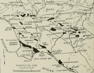
Oil and gas are found mostly in the younger rock layers, especially near the coast. The Puente formation is a very important source of oil in the basin. The oil is trapped in thick layers of oil sands, which can be hundreds or even thousands of feet thick. Folds in the rock layers (anticlines) and faults also help trap the oil.
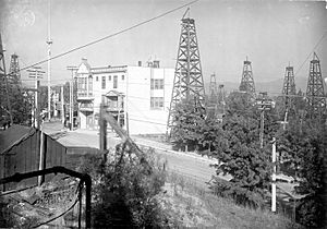
The first oil-producing well in the basin was found in 1892, where Dodger Stadium is today. For a long time, this basin produced half of California's oil! This is amazing considering how small and young the basin is. Today, there are about 40 active oil fields with 4,000 working wells. In 1904, there were over 1,150 wells just in Los Angeles! Many wells dried up because they were too close together and pumped constantly. In 2013, the basin produced 255 million barrels of oil, which is much less than the almost 1 billion barrels per year produced in the late 1970s.
Images for kids
 | William L. Dawson |
 | W. E. B. Du Bois |
 | Harry Belafonte |


