
Santa Ana Mountains facts for kids
Quick facts for kids Santa Ana Mountains |
|
|---|---|

(2008)
|
|
| Highest point | |
| Peak | Santiago Peak |
| Elevation | 5,689 ft (1,734 m) |
| Dimensions | |
| Length | 61 mi (98 km) |
| Area | 2,104 sq mi (5,450 km2) |
| Geography | |
 |
|
| Country | United States |
| Geology | |
| Age of rock | Triassic and Jurassic |
| Type of rock | metasedimentary |
The Santa Ana Mountains are a mountain range found along the coast of Southern California in the United States. They stretch for about 61 miles (98 km) to the southeast of the Los Angeles Basin. These mountains mostly form the border between Orange and Riverside counties.
Contents
Exploring the Santa Ana Mountains
Where are the Santa Ana Mountains?
The Santa Ana Mountains begin in the north near the Whittier Fault and Santa Ana Canyon. The Santa Ana River flows through this canyon. North of the canyon are the smaller Chino Hills.
The highest point in the Santa Anas is Santiago Peak, which is 5,689 feet (1,734 meters) tall. Another important peak, Modjeska, is 5,496 feet (1,675 meters) high. These two peaks together form a famous shape called Saddleback Ridge. Saddleback is about 20 miles (32 km) east of Santa Ana and can be seen from many parts of Southern California.

South of Saddleback, you'll find other peaks like Trabuco Peak (4,613 feet or 1,406 meters) and Los Pinos Peak (4,510 feet or 1,375 meters). A subrange called the Elsinore Mountains is west of Lake Elsinore. The mountains end near the Santa Margarita River.
Much of the Santa Ana Mountains are part of the Cleveland National Forest. Some parts are also owned by old ranches like the Irvine Ranch and Rancho Mission Viejo.
Rivers and Lakes in the Mountains
The Santa Anas have many streams that flow for most of the year, especially in the higher parts. However, once they leave the mountains, these streams often dry up for parts of the year. This means they are ephemeral.
Major streams on the western side of the mountains flow into the Pacific Ocean. These include San Diego Creek, Aliso Creek, and San Mateo Creek. The Santa Ana River defines the northern side of the range. Santiago Creek drains much of the northern mountains and joins the Santa Ana River near Orange.
On the northeast side, water flows into Temescal Creek or Lake Elsinore. The Santa Margarita River marks the southeast end of the range.
Irvine Lake is the largest freshwater lake in Orange County. It is located in the northwest part of the mountains and was created by the Santiago Dam on Santiago Creek.
What is the Climate Like?
The Santa Ana Mountains have a Mediterranean climate. This means they have warm, dry summers and cool, wet winters. The higher parts of the mountains get more rain, usually between 20 to 30 inches (500–760 mm) each year. The lower areas near the coast get less, about 13–16 inches (350–400 mm). Most of the rain falls from November to March. Snow can fall on the highest peaks during winter.
History of the Santa Ana Mountains
How the Mountains Got Their Name
The mountains were named by explorers from Gaspar de Portolà's expedition. They camped near the mountains on July 26, 1769. This day is known as the Feast Day of Saint Anne, so they named the mountains after her.
Early People of the Mountains
When Portolà visited, three main groups of indigenous peoples lived in the Santa Anas. The Tongva lived in the north, the Acjachemen in the west, and the Payomkowishum in the east and south.
Important Historical Places
Several historical sites can still be found in the mountains today. These include an Indian Village Site in Black Star Canyon and Flores Peak, named after an outlaw. There are also sites of old mining towns like Carbondale and Silverado. Helena Modjeska's home is another historic spot.

The Moreno and Machado Adobes are found on the Santa Rosa Plateau Ecological Reserve. These are old adobe buildings from the Rancho Santa Rosa.
Plants and Animals of the Santa Anas
Amazing Plants of the Mountains
The Santa Ana Mountains are home to many different types of plants. This area is part of the California Floristic Province, which means it has a lot of plant diversity. You can find various plant communities, including:
- Coastal sage scrub: Short, woody shrubs that grow in dry areas.
- Chaparral: Dense shrubs that are good at surviving fires.
- Riparian woodland: Trees and plants that grow near streams and rivers.
- Southern oak woodland: Areas with different kinds of oak trees.
- Vernal pools: Small, temporary ponds that fill with water in winter and spring.
Rare flowers like the intermediate Mariposa lily and chocolate lily can be found here. You might also see fragrant sages, evergreen shrubs, and unique succulents like Dudleya species. Many ferns grow under trees and near streams, especially in higher areas.
Diverse Animals of the Mountains
The Santa Ana Mountains are home to a surprising number of wildlife species. You might spot:
- Large mammals: Mountain lions, mule deer, bobcats, coyotes, and gray foxes.
- Smaller mammals: American badgers, ring-tailed cats, spotted skunks, western gray squirrels, and different kinds of bats.
- Birds: Spotted owls, golden eagles, mountain quails, and canyon wrens.
- Reptiles and amphibians: Western pond turtles, coast horned lizards, speckled rattlesnakes, Pacific rattlesnakes, common kingsnakes, gopher snakes, arroyo toads, and California tree frogs.
- Insects: The California sister butterfly and various types of tarantulas.
Sadly, some animals that once lived here are no longer found in the wild. The last wild grizzly bear in the Santa Ana Mountains was seen in 1908. Gray wolves, pronghorn, and California condors also used to live in this range.
Resources and Transportation
Natural Resources of the Mountains
People have mined different minerals in the Santa Ana Mountains, but none were very profitable. Since the 1870s, people have collected metals like lead, silver, tin, and zinc. They also found minerals such as clay, coal, gypsum, and limestone.
For a long time, parts of the mountains have been used for grazing farm animals and harvesting timber. As cities grew around the mountains, the water from the creeks became a very important resource.
Getting Around the Mountains
The Santa Ana Mountains create a natural barrier between the Inland Empire to the east and the cities of Orange County to the west. Only two main roads connect these areas:
- State Route 91 (California)|State Route 91 (the Riverside Freeway): This freeway follows the Santa Ana River through a pass between the Santa Ana Mountains and the Chino Hills. It is one of California's busiest roads.
- California State Route 74 (the Ortega Highway): This is a two-lane road. While Highway 91 is very busy, Highway 74 is known as one of the most dangerous highways in the state.
Because Highway 91 is so crowded, there have been ideas to build a highway tunnel through the Santa Ana Mountains. However, this idea would be very expensive and has raised concerns from environmental groups and others about the cost and safety, especially since the area has earthquakes.

Images for kids
-
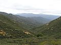
San Mateo Canyon Wilderness, southern Santa Ana Mountains, April 2007. This area has chaparral plants, which are common in the mountains.
-
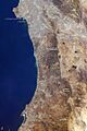
The Santa Ana Mountains, with other mountain ranges and landforms in Southern California.
-
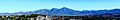
The Santa Ana Mountains as seen from Mission Viejo (December 2013). The two highest peaks, Modjeska (left) and Santiago (right), form Saddleback.
See also
 In Spanish: Sierra de Santa Ana para niños
