Lake Elsinore facts for kids
Quick facts for kids Lake Elsinore |
|
|---|---|

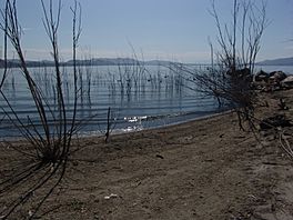
Shore of Lake Elsinore
|
|
| Location | Riverside County, California |
| Coordinates | 33°39′33″N 117°20′57″W / 33.65917°N 117.34917°W |
| Type | Sag pond |
| Primary inflows | San Jacinto River, Leach Canyon, McVicker Canyon |
| Primary outflows | Temescal Wash |
| Catchment area | 750 sq mi (1,900 km2) |
| Basin countries | United States |
| Max. length | 6 mi (9.7 km) (max) |
| Max. width | 1.5 mi (2.4 km) (max) |
| Surface area | 2,993 acres (1,211 ha) (normal) 3,452 acres (1,397 ha) (full) |
| Average depth | 27 ft (8.2 m) |
| Max. depth | 42 ft (13 m) |
| Water volume | 41,700 acre⋅ft (51,400 dam3) (normal) 89,900 acre⋅ft (110,900 dam3) (full) |
| Shore length1 | 14 mi (23 km) |
| Surface elevation | 1,240 ft (380 m) (normal) 1,255 ft (383 m) (full) |
| Settlements | Lake Elsinore, Lakeland Village |
| 1 Shore length is not a well-defined measure. | |
Lake Elsinore is a natural freshwater lake in Riverside County, California. It is located east of the Santa Ana Mountains and gets its water mainly from the San Jacinto River. Spanish explorers first called it Laguna Grande. It was later renamed for the town of Elsinore, which was founded on its northeastern shore in 1888.
Contents
About Lake Elsinore
Lake Elsinore is the biggest natural freshwater lake in Southern California. It sits in a special area called a watershed, which covers about 750 square miles (1,900 km2). This means all the rain and streams in that large area eventually flow into the lake. It's at the lowest point of the San Jacinto River system.
The lake is known for its changing water levels. Its normal level is about 1,240 feet (378 meters) above sea level. When the lake reaches 1,255 feet (383 meters), it overflows into a channel called Temescal Wash. This water then flows through Temescal Canyon and eventually reaches the Santa Ana River.
Over the years, a lot of work has been done to keep the lake from drying up or flooding too much. This helps keep the lake healthy for both people and wildlife.
Lake History
People have known about Lake Elsinore for a long time. A Spanish explorer named Juan Santiago first saw it in 1797. In 1810, it was described as a small swamp. But later in the 1800s, the lake grew much larger.
Early Travelers and Gold Rush
The lake became an important stop for travelers. Mexican rancheros, American trappers, and people heading to the California Gold Rush used it to camp and water their animals. They traveled along the lake's southern shore on routes like the Southern Emigrant Trail.
In 1850, a traveler named Benjamin Ignatius Hayes described the lake. He noted that the water was a bit salty, so animals couldn't drink it. He also saw many geese and an adobe house nearby.
Floods and Dry Spells
Lake Elsinore's water levels have changed a lot throughout history.
- 1862: A huge flood made the lake very high. The army even used it to water their horses.
- 1862-1865: A severe drought caused the lake level to drop dramatically.
- 1872: Heavy rains filled the lake again, and it overflowed.
- 1883-1884: After another dry period, massive rains filled the lake in just three weeks. Old willow trees that were once on the shore became submerged.
- 1893: The lake water was bought by a company to irrigate farms in Corona, California. They tried to pump water from the lake, but it became too salty for farming.
- 1916: Another flood caused the lake to overflow.
Modern History
In the 1920s, Lake Elsinore was used for Olympic training and fast boat races. However, it completely dried up in the mid-1930s and again in the 1950s. It refilled in the early 1960s.
In 1980, heavy rains caused the lake to flood, damaging homes and businesses nearby. Since then, a big project has been put in place to keep the water level steady. This allows people to build homes safely near the lake. In 2007, a special system was added to put air into the lake. This helps prevent fish from dying when oxygen levels get too low.
Lake Geography
Lake Elsinore sits in a valley called the Elsinore Valley. This valley is a type of rift valley formed by cracks in the Earth's crust. The lake itself is the largest "sag pond" in the Elsinore Fault Zone, which is a major crack in the Earth.
The lake is surrounded by hills and mountains. To the west are the Santa Ana Mountains. Many small streams, called arroyos, flow into the lake from these mountains. On the northwestern side, the land rises to the foothills of the Santa Ana Mountains. Two larger streams, Leach Canyon Creek and McVicker Canyon Creek, also flow into the north side of the lake.
The southern part of the lake is an open area where the San Jacinto River enters. This river is the lake's main source of water. A flood-control wall has been built to protect parts of the land from flooding during very heavy rains.
Water Flow
Lake Elsinore is part of a basin that is usually "endorheic." This means water flows into it but doesn't usually flow out to the ocean. However, when there's a lot of rain or snowmelt, the lake can overflow. When the lake reaches 1,255 feet (383 meters), water flows out through the Elsinore Spillway Channel into Temescal Creek. This creek then flows into the Santa Ana River. In recent years, efforts to keep the lake full have made these overflows happen more often.
 | Bessie Coleman |
 | Spann Watson |
 | Jill E. Brown |
 | Sherman W. White |


