
San Jacinto River (California) facts for kids
Quick facts for kids San Jacinto River |
|
|---|---|

The mouth of the San Jacinto on Lake Elsinore, viewed from California State Route 74 (the Ortega Highway) on the southwest side of the lake
|
|

Map of the Santa Ana River watershed with the San Jacinto subbasin highlighted in yellow.
|
|
| Country | United States |
| State | California |
| Region | Riverside County |
| Cities | Hemet, San Jacinto, Perris, Lake Elsinore |
| Physical characteristics | |
| Main source | San Jacinto Mountains San Bernardino National Forest, Riverside County 2,100 ft (640 m) 33°43′52″N 116°48′36″W / 33.73111°N 116.81000°W |
| River mouth | Lake Elsinore Lake Elsinore, at the mouth of Railroad Canyon, northwest of the Sedco Hills and west of the Tuscany Hills of the Temescal Mountains, Riverside County 1,243 ft (379 m) 33°38′45.06″N 117°18′53.42″W / 33.6458500°N 117.3148389°W |
| Length | 42 mi (68 km), Northwest then southwest |
| Basin features | |
| River system | Santa Ana River basin |
| Basin size | 780 sq mi (2,000 km2) |
| Tributaries |
|
The San Jacinto River is a 42-mile (68 km) long river in Riverside County, California. It starts high up in the Santa Rosa and San Jacinto Mountains National Monument. The river's path takes it through both natural areas and busy towns and farms.
The area that collects water for the river is called a watershed. This watershed covers about 765 square miles (1,980 km²). A special thing about this river is that it's part of an endorheic watershed. This means its water usually stays within its own basin and doesn't flow out to the ocean.
Contents
The River's Journey: Where it Starts and Flows
The San Jacinto River begins where two smaller streams meet. These are called the North Fork and the South Fork. They join together at the western base of the San Jacinto Mountains.
The South Fork's Path
The South Fork starts near Santa Rosa Summit. It flows through places like Pine Meadow and Garner Valley. This fork then reaches Lake Hemet. This lake can hold a lot of water, about 14,000 acre-feet (17,000,000 m³). Hemet Dam was built in 1895 to provide water for the city of Hemet.
Joining Forces and Heading Northwest
After Lake Hemet, the South Fork meets the North Fork. This meeting point is east of Valle Vista, near Highway 74. From there, the main San Jacinto River flows northwest. It eventually empties into Mystic Lake, which is a few miles east of Lake Perris.
Flowing to Lake Elsinore
Sometimes, when there's a lot of rain, water from the river overflows from Mystic Lake. This overflow then travels southwest. It passes under the Ramona Expressway and Interstate 215. The river then flows through Railroad Canyon into Railroad Canyon Reservoir. This reservoir is also known as Canyon Lake. It can hold about 11,900 acre-feet (14,700,000 m³) of water.
After Canyon Lake, the river continues flowing west-southwest. It goes through a canyon in the Temescal Mountains for about 3 miles (4.8 km). Finally, it drains into Lake Elsinore.
Lake Elsinore and Beyond
Lake Elsinore usually doesn't have water flowing out of it. Most of its water simply evaporates. However, during very rainy years, the lake can overflow. When this happens, the extra water flows into Temescal Creek. This creek then flows northwest and eventually joins the Santa Ana River in Corona, California.
Main Branches of the San Jacinto River
The San Jacinto River has several smaller streams and creeks that flow into it. These are called tributaries. The two most important ones are its main forks:
- North Fork San Jacinto River
- South Fork San Jacinto River
Other notable creeks that join the river or its branches include:
- Cottonwood Canyon Creek
- Salt Creek
- Bautista Creek
- Indian Creek
Images for kids
-
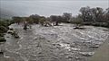
The San Jacinto River during a big storm on February 13-14, 2019. The town of San Jacinto got 3.66 inches of rain on February 14. This photo was taken from the State Street bridge.

