
San Jacinto, California facts for kids
Quick facts for kids
San Jacinto
|
||
|---|---|---|

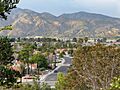
San Jacinto neighborhood with San Jacinto Mountains in the background
|
||
|
||

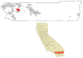
Location in Riverside County and the state of California
|
||

San Jacinto
Location in the United States
|
||
| Country | ||
| State | ||
| County | ||
| Native American Reservation (partial) | Soboba Band of Luiseño Indians | |
| Incorporated | April 20, 1888 | |
| Named for | St. Hyacinth of Caesarea | |
| Government | ||
| • Type | Council-Manager | |
| Area | ||
| • Total | 26.12 sq mi (67.66 km2) | |
| • Land | 25.96 sq mi (67.23 km2) | |
| • Water | 0.17 sq mi (0.43 km2) 1.59% | |
| Elevation | 1,565 ft (477 m) | |
| Population
(2020)
|
||
| • Total | 53,898 | |
| • Density | 2,063.5/sq mi (796.60/km2) | |
| Time zone | UTC-8 (PST) | |
| • Summer (DST) | UTC-7 (PDT) | |
| ZIP codes |
92581-92583
|
|
| Area code(s) | 951 | |
| FIPS code | 06-67112 | |
| GNIS feature IDs | 1652787, 2411788 | |

San Jacinto is a city in Riverside County, California, United States. It is found at the north end of the San Jacinto Valley. The city of Hemet is to its south, and Beaumont is to its north. The San Jacinto Mountains are near the valley. In 2010, the population was 44,199 people. The city was started in 1870 and became an official city on April 20, 1888. This makes it one of the oldest cities in Riverside County.
San Jacinto is home to Mt. San Jacinto College, a community college that opened in 1965. The city will also be the eastern end of the Mid County Parkway. This new road will connect San Jacinto to Perris. In the late 1800s and early 1900s, San Jacinto was known for its many dairies and farms.
The city also has the Soboba Casino. This casino is owned and run by the Soboba Band of Luiseño Indians. The Soboba people manage their own community affairs.
Contents
History of San Jacinto

The Luiseño were the first people to live in the area now called the San Jacinto Valley. They had many villages there.
The Anza Trail was one of the first European routes into California. It was named after Juan Bautista de Anza. This trail crossed the valley in the 1770s. Around 1820, missionaries from Spain named the valley San Jacinto, which means Saint Hyacinth. They also set up an outpost there.
In 1883, the San Jacinto Land Association planned out the modern city of San Jacinto. The railroad came to the city in 1888. The city government officially started that same year.
For many years, farming was the main way people made a living in San Jacinto. The city also became popular with tourists who visited the nearby hot springs. The city and its people helped start the Ramona Pageant in 1923. This is California's official State Outdoor Play, and the city has supported it ever since.
On July 15, 1937, San Jacinto was the end point for a record-breaking airplane flight. Mikhail Gromov and his crew flew 6,262-mile (10,078 km) from Moscow, USSR. This was the longest non-stop polar flight at that time. This flight followed another historic flight over the pole by Valery Chkalov's crew earlier that year. These flights set new world records. Later, a stone marker was placed in San Jacinto to remember Gromov's flight. The landing site is also a California State Historical Landmark.
Geography and Earthquakes
San Jacinto is located at 33°47′14″N 116°58′0″W / 33.78722°N 116.96667°W.
The city covers about 26.1 square miles (68 km2) of land. Most of this is land, and a small part is water. The San Jacinto reservoir is an artificial lake. It holds water for the San Diego Aqueduct, which is part of the Colorado River Aqueduct. This reservoir is west of town.
San Jacinto has experienced two large earthquakes. One happened on Christmas Day in 1899. The other was on April 21, 1918.
Climate in San Jacinto
San Jacinto has a hot-summer mediterranean climate. This means it has hot, dry summers. Its winters are cool and wet.
| Climate data for San Jacinto, California, 1991–2020 normals, extremes 1978–present | |||||||||||||
|---|---|---|---|---|---|---|---|---|---|---|---|---|---|
| Month | Jan | Feb | Mar | Apr | May | Jun | Jul | Aug | Sep | Oct | Nov | Dec | Year |
| Record high °F (°C) | 91 (33) |
91 (33) |
99 (37) |
103 (39) |
110 (43) |
114 (46) |
115 (46) |
115 (46) |
116 (47) |
108 (42) |
96 (36) |
90 (32) |
116 (47) |
| Mean maximum °F (°C) | 81.1 (27.3) |
82.1 (27.8) |
87.3 (30.7) |
93.5 (34.2) |
98.4 (36.9) |
104.0 (40.0) |
107.2 (41.8) |
108.3 (42.4) |
105.5 (40.8) |
98.4 (36.9) |
89.3 (31.8) |
81.2 (27.3) |
110.2 (43.4) |
| Mean daily maximum °F (°C) | 65.8 (18.8) |
65.8 (18.8) |
70.2 (21.2) |
74.4 (23.6) |
80.4 (26.9) |
88.7 (31.5) |
95.1 (35.1) |
96.5 (35.8) |
91.8 (33.2) |
82.3 (27.9) |
72.7 (22.6) |
65.0 (18.3) |
79.1 (26.1) |
| Daily mean °F (°C) | 52.9 (11.6) |
53.7 (12.1) |
57.6 (14.2) |
61.2 (16.2) |
66.8 (19.3) |
73.2 (22.9) |
79.3 (26.3) |
80.4 (26.9) |
76.3 (24.6) |
67.5 (19.7) |
58.5 (14.7) |
52.0 (11.1) |
65.0 (18.3) |
| Mean daily minimum °F (°C) | 40.1 (4.5) |
41.7 (5.4) |
45.0 (7.2) |
47.9 (8.8) |
53.3 (11.8) |
57.6 (14.2) |
63.6 (17.6) |
64.3 (17.9) |
60.7 (15.9) |
52.7 (11.5) |
44.4 (6.9) |
39.0 (3.9) |
50.9 (10.5) |
| Mean minimum °F (°C) | 29.4 (−1.4) |
32.4 (0.2) |
35.2 (1.8) |
38.0 (3.3) |
43.8 (6.6) |
49.1 (9.5) |
54.2 (12.3) |
54.3 (12.4) |
50.3 (10.2) |
41.9 (5.5) |
33.5 (0.8) |
28.4 (−2.0) |
25.0 (−3.9) |
| Record low °F (°C) | 7 (−14) |
16 (−9) |
17 (−8) |
24 (−4) |
30 (−1) |
31 (−1) |
40 (4) |
37 (3) |
35 (2) |
24 (−4) |
19 (−7) |
17 (−8) |
7 (−14) |
| Average precipitation inches (mm) | 2.66 (68) |
2.76 (70) |
1.69 (43) |
0.79 (20) |
0.47 (12) |
0.07 (1.8) |
0.20 (5.1) |
0.12 (3.0) |
0.26 (6.6) |
0.54 (14) |
0.77 (20) |
1.87 (47) |
12.20 (310) |
| Average precipitation days (≥ 0.01 in) | 6.2 | 6.2 | 5.3 | 2.9 | 2.3 | 0.3 | 0.6 | 0.6 | 0.9 | 1.8 | 3.0 | 5.1 | 35.2 |
| Source 1: NOAA | |||||||||||||
| Source 2: National Weather Service | |||||||||||||
People of San Jacinto: Demographics
| Historical population | |||
|---|---|---|---|
| Census | Pop. | %± | |
| 1890 | 661 | — | |
| 1900 | 583 | −11.8% | |
| 1910 | 898 | 54.0% | |
| 1920 | 945 | 5.2% | |
| 1930 | 1,346 | 42.4% | |
| 1940 | 1,356 | 0.7% | |
| 1950 | 1,778 | 31.1% | |
| 1960 | 2,553 | 43.6% | |
| 1970 | 4,385 | 71.8% | |
| 1980 | 7,098 | 61.9% | |
| 1990 | 16,210 | 128.4% | |
| 2000 | 23,779 | 46.7% | |
| 2010 | 44,199 | 85.9% | |
| 2019 (est.) | 49,215 | 11.3% | |
| U.S. Decennial Census | |||
Population in 2010
The 2010 United States Census showed that San Jacinto had 44,199 people. About 99.5% of these people lived in homes.
There were 13,152 households in the city.
- 6,460 (49.1%) had children under 18.
- 6,954 (52.9%) were married couples.
- 2,121 (16.1%) had a female head of household with no husband.
- 912 (6.9%) had a male head of household with no wife.
- The average household size was 3.34 people.
The population was spread out by age:
- 14,487 people (32.8%) were under 18.
- 4,404 people (10.0%) were 18 to 24.
- 11,885 people (26.9%) were 25 to 44.
- 8,755 people (19.8%) were 45 to 64.
- 4,668 people (10.6%) were 65 or older.
The average age was 30.3 years.
The median income for a household in San Jacinto was $47,453 in 2010. About 18.9% of the people lived below the poverty line.
Things to See and Do: Tourism

San Jacinto has a special memorial for veterans at Druding Park. It honors the men and women who served in the U.S. Armed Services. Each branch of the military has a piece of equipment there. There is a tank for the Army, a propeller for the Air Force, and an anchor for the Navy. There is also a lighthouse for the Coast Guard. The city hopes to add a howitzer for the Marine Corps soon. Many plaques and memorials are also in the park.
The city is also home to the Estudillo Mansion. This was the home of Francisco Estudillo. He was the city's first postmaster and its second mayor. His brother, Jose Antonio Estudillo, Jr., built a similar mansion nearby. These two mansions and their land are all that remain of a large 35,000-acre (140 km2) land grant. This grant was given to their father in 1842. The mansion is now on the National Register of Historic Places. It is also on the California Register of Historic Resources. This is a great honor for the mansion.
Community Services
Education in San Jacinto
Most of the city is served by the San Jacinto Unified School District. This district has 12 schools. There is one main high school, San Jacinto High School (San Jacinto, California). There is also a continuation high school called Mountain View High School. The city has 7 elementary schools and 3 middle schools. There is also an independent studies program. The San Jacinto Leadership Academy is a special school for grades 6-12. It serves almost 600 students.
Some parts of San Jacinto are in other school districts. These include the Hemet Unified School District and the Nuview Union Elementary School District. The Perris Union High School District serves high school students in some areas.
The San Jacinto Valley Academy is a charter school. It teaches students from kindergarten through 12th grade.
Cemetery
The San Jacinto Valley Cemetery District manages the San Jacinto Valley Cemetery. A famous person buried there is Henning Dahl Mikkelsen. He was a Danish cartoonist who created the comic strip Ferd'nand.
Arts and Culture
The Diamond Valley Arts Council (DVAC) runs an arts center. It is called the Esplanade Arts Center (EAC). This center has an art gallery. It also offers community arts classes. There is a performance space where the Inland Stage Company (ISC) performs plays.
Sports in San Jacinto
Mt. San Jacinto College has sports teams called the Eagles. They have a stadium for college football. There is also a gymnasium for college basketball. They have a baseball park for the Diamond Valley Sabers. This team plays in the SCCBL (Southern California Baseball League). They also play some home games in Hemet.
The So Cal Coyotes football team plays some of their home games at the Soboba Casino Oaks Sports Complex. They moved their main home field to Indio in 2018.
The Soboba Casino's sports complex also has an indoor facility. It is used for boxing events on the Soboba Indian Reservation.
Images for kids
-
San Jacinto neighborhood with San Jacinto Mountains in the background
-

Flag of San Jacinto, California
-
Location in Riverside County and the state of California
-
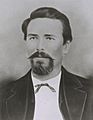
Don José Antonio Estudillo, considered to be the founder of San Jacinto
-
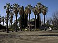
Estudillo Mansion
See also
 In Spanish: San Jacinto (California) para niños
