
Colorado River Aqueduct facts for kids
Quick facts for kids
Colorado River Aqueduct
|
|
|---|---|

Parker Dam on Lake Havasu where Colorado River waters are initially drawn into the system
|
|
| Begins | Lake Havasu, San Bernardino County 34°17′24″N 114°10′20″W / 34.289894°N 114.172094°W |
| Ends | Lake Mathews, Riverside County 33°50′14″N 117°22′41″W / 33.837240°N 117.378098°W |
| Maintained by | Metropolitan Water District of Southern California |
| Characteristics | |
| Total length | 242 mi (389 km) |
| Capacity | 1,600 cu ft/s (45 m3/s) |
| History | |
| Construction start | 1933 |
| Opened | 7 January 1939 |


The Colorado River Aqueduct, also called CRA, is a very long water channel in Southern California, United States. It is 242 mi (389 km) (about 390 kilometers) long. The Metropolitan Water District of Southern California (MWD) operates it.
The aqueduct takes water from the Colorado River at Lake Havasu. This lake is on the border between California and Arizona. The water then travels west across the Mojave and Colorado deserts. It ends on the east side of the Santa Ana Mountains. This aqueduct is one of the main ways Southern California gets its drinking water.
William Mulholland first thought of the idea for the aqueduct. Frank E. Weymouth, the Chief Engineer for the MWD, designed it. This project was the biggest public works project in Southern California during the Great Depression. It gave jobs to 30,000 people over eight years. At one time, 10,000 people worked on it.
The whole system has two reservoirs, which are like big storage lakes. It also has five pumping stations to push the water uphill. There are 62 mi (100 km) (about 100 km) of open canals. Water also flows through 92 mi (148 km) (about 148 km) of tunnels. Finally, there are 84 mi (135 km) (about 135 km) of buried pipes and siphons. Each year, the aqueduct moves about 1,200,000 acre⋅ft (1.5 km3) of water.
How the Water Travels
The Colorado River Aqueduct starts near Parker Dam on the Colorado River. Here, powerful pumps lift the water up the Whipple Mountains. After this first lift, the water flows through 60 mi (97 km) (about 97 km) of siphons and open canals. These canals cross the southern Mojave Desert.
At a place called Iron Mountain, the water is lifted again. This lift is 144 ft (44 m) (about 44 meters) high. The aqueduct then turns southwest towards the Eagle Mountains. There, the water is lifted two more times. First, it goes up 438 ft (134 m) (about 133 meters). This brings it to an elevation of over 1,400 ft (430 m) (about 427 meters). Then, it goes up another 441 ft (134 m) (about 134 meters). This reaches an elevation of 1,800 ft (550 m) (about 549 meters) above sea level.
The CRA then goes through the deserts of the Coachella Valley. It also passes through the San Gorgonio Pass. Near Cabazon, the aqueduct goes underground. It stays underground until it enters the San Jacinto Tunnel. This tunnel is at the base of the San Jacinto Mountains. After the mountains, the aqueduct continues underground. It finally reaches its end point at Lake Mathews.
From Lake Mathews, a network of 156 mi (251 km) (about 251 km) of distribution lines takes the water to different cities. There are also eight more tunnels in this network. Some water is sent to San Diego County. This happens through the San Diego canal, which is part of the San Diego Aqueduct.

Building the Aqueduct
As the Los Angeles area grew very fast in the early 1900s, people needed more water. William Mulholland and other engineers looked for new water sources. Los Angeles had already built the 240-mile (390 km) Los Angeles Aqueduct in 1913. This aqueduct brought water from the Owens Valley.
By the 1920s, Los Angeles had grown so much that the Owens River could not provide enough water. So, in 1923, Mulholland and his team looked to the Colorado River. The plan was to build a dam on the Colorado River. Then, they would carry its water hundreds of miles across mountains and deserts.
In 1924, steps were taken to create a special water district. This district would include many cities in Southern California. The Metropolitan Water District ("Met") was officially formed on December 6, 1928. In 1929, Met took over the plans for the Colorado River aqueduct.
The MWD looked at eight different paths for the aqueduct. In 1931, they chose the "Parker route." This route needed the building of the Parker Dam. It was chosen because it was considered the safest and most affordable. People approved a $220 million bond to pay for it on September 29, 1931.
Construction began in January 1933 near Thousand Palms. In 1934, the United States Bureau of Reclamation started building the Parker Dam. The aqueduct itself was finished in 1935. Water first flowed through the aqueduct on January 7, 1939.
The CRA helped Southern California grow a lot. In 1955, the American Society of Civil Engineers (ASCE) called the aqueduct one of the "Seven Engineering Wonders of American Engineering." This shows how amazing this project was.
In Pop Culture
The Colorado River Aqueduct was shown by Huell Howser in his TV show California's Gold.
See also
 In Spanish: Acueducto del río Colorado para niños
Images for kids
-
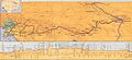
Map from The Metropolitan Water District of Southern California, History and First Annual Report for the Period Ending June 30, 1938.
