
Los Angeles Aqueduct facts for kids
Quick facts for kids Los Angeles Aqueduct |
|
|---|---|

The Second Los Angeles Aqueduct Cascades, Sylmar
|
|
| Official name | Los Angeles Aqueduct Second Los Angeles Aqueduct Mono Extension |
| Maintained by | Los Angeles Department of Water and Power |
| Characteristics | |
| Total length | 419 mi (674 km) |
| History | |
| Construction begin | First Aqueduct October 1908 Second Aqueduct September 1965 |
| Opened | First Aqueduct November 1913 Second Aqueduct June 1970 |
The Los Angeles Aqueduct system is a huge water delivery network. It includes the original Los Angeles Aqueduct (also called the Owens Valley Aqueduct) and the Second Los Angeles Aqueduct. This system was built and is run by the Los Angeles Department of Water and Power.
The first aqueduct was designed by William Mulholland, who was the chief engineer. This amazing system brings water all the way from the Owens River in the Eastern Sierra Nevada Mountains to the city of Los Angeles, California.
Building the aqueduct was quite controversial. It involved taking water from the Owens Valley, which made it hard for farmers there. Even today, running the aqueduct causes debates and legal battles. These discussions are about how the aqueduct affects places like Mono Lake and other natural areas.
Contents
Building the First Aqueduct
The idea for the aqueduct started in 1905. Voters in Los Angeles approved a US$1.5 million bond to buy land and water. This money also helped start the aqueduct project. In 1907, a second bond for US$24.5 million was passed to pay for the actual building.
Construction began in 1908. The project was split into eleven parts, and a cement plant was also built. In the first year, 2,629 people worked on the aqueduct. This number grew to 6,060 workers by May 1909.
By 1913, the City of Los Angeles finished building the first aqueduct. It had six storage reservoirs and 215 mi (346 km) of water channels. The aqueduct takes water from the Owens River and sends it on a 233 mi (375 km) journey south. The water ends up at the Lower Van Norman Reservoir.
The original aqueduct used different types of channels. It had open canals, covered concrete channels, tunnels, and steel pipes called siphons. The project also included building railroads, power plants, cement plants, power lines, telephone lines, and roads. Later, the Mono Extension and the Second Los Angeles Aqueduct were added to this system.
A cool fact about the aqueduct is that it uses only gravity to move the water. This means it doesn't need big pumps, which saves a lot of energy. The water also helps generate electricity. This makes the aqueduct very cheap to run. It has been working safely for many years and is still in use today.

Mono Basin Extension
Los Angeles needed even more water, so the city looked further north. In 1930, Los Angeles voters approved another US$38.8 million bond. This money was used to buy land in the Mono Basin and build the Mono Basin extension.
This 105 mi (169 km) extension redirected water from creeks like Rush Creek and Lee Vining Creek. Normally, this water would flow into Mono Lake. The Mono extension included an intake at Lee Vining Creek and a channel to the Grant Reservoir. It also had a long tunnel called the Mono Craters Tunnel. This tunnel connected to the Owens River. A second reservoir, later named Crowley Lake, was also built.
The Mono Extension was finished in 1940, and water started flowing in 1941. It was designed to carry 400 cu ft/s (11,000 L/s) of water. However, the flow was limited to 123 cu ft/s (3,500 L/s) at first. This was because the original Los Angeles Aqueduct couldn't handle more water. The full amount of water could only be used after the second aqueduct was completed in 1970.
Mono Extension's Impact on Mono Lake
Between 1940 and 1970, a lot of water was taken from the Mono Basin. This amount sometimes reached 135,000 acre⋅ft (167 million m3) per year. By 1974, even more water was allowed to be taken, up to 167,000 acre⋅ft (206 million m3) each year.
Taking so much water had a big effect on the fish, the lake level, and even the air quality in the region. This led to many lawsuits. Eventually, a decision was made to protect the fish by making sure enough water flowed in the streams. It also aimed to raise Mono Lake's water level. Now, only 10,000 acre⋅ft (12.3 million m3) of water can be taken from the Mono Basin each year.
Second Los Angeles Aqueduct
In 1956, a report showed that Los Angeles was not using all the water it was allowed from the Owens Valley and Mono Basin. Three years later, the state warned Los Angeles that it might lose its rights to this unused water.

To avoid losing future water supply, Los Angeles started building a second aqueduct in 1965. This project cost US$89 million and took five years to build. Once the city got permission to divert more water, exports jumped. By 1974, Los Angeles was taking 450,000 acre⋅ft (560 million m3) of water per year.
The Second Aqueduct is 137-mile-long (220 km). It was designed to carry 290 cu ft/s (8,200 L/s) of water. It starts at the Merritt Diversion Structure, near the Haiwee Reservoirs. It runs mostly next to the first aqueduct. Water flows downhill by gravity from an elevation of 3,760 feet (1,150 m) at Haiwee Reservoir to 1,200 ft (370 m) at the Upper Van Norman Reservoir.
The Second Aqueduct was not built as one continuous channel. It was divided into a Northern and Southern section. These two parts are connected by the San Francisquito Tunnels, which are actually part of the First Aqueduct.
The Northern Section carries water from the North Haiwee Reservoir. It flows south for 115 miles (185 km) through pipes and concrete channels. It then connects with the First Aqueduct near the Fairmont Reservoir.
The San Francisquito Tunnels are very large. They can handle the water flow from both aqueducts. After the combined water reaches the power plants, some water is sent into the Southern Section of the second aqueduct. This water goes through the Drinkwater Tunnel to the Drinkwater Reservoir.

The last part of the pipe is called the Saugus Pipeline. It carries water south past areas like Bouquet Canyon and Placerita Canyon. From there, it goes towards the Terminal structure and Cascades. Water from the Terminal structure can then flow to the Cascade or to the Foothill Power Plant and into the Upper Van Norman Reservoir.
Improvements were also made to the first aqueduct's lined canal. Its capacity was increased from 710 cu ft/s (20,000 L/s) to 900 cu ft/s (25,000 L/s).
Second Aqueduct's Impact on Water Supply
The extra water from the second aqueduct only lasted from 1971 to 1988. By 1974, people started to notice the environmental problems caused by taking so much water. This led to court orders that limited how much water Los Angeles could take.
As a result, Los Angeles lost some of its water supply. In 2005, a report showed that 40–50% of the aqueduct's water now goes to help the environment in Mono and Inyo counties.
How the Aqueduct Changed Los Angeles
Between 1909 and 1928, the city of Los Angeles grew a lot. It went from 61 square miles to 440 square miles. This huge growth was mostly thanks to the aqueduct. The city's rules said that Los Angeles could not sell or give extra water to areas outside the city.
Areas around Los Angeles relied on wells and creeks for water. When these dried up, people in those areas realized they needed to join Los Angeles to get water for their farms and homes. So, many areas became part of the city.
The city grew so fast that it seemed like Los Angeles might take over the whole county. William Mulholland kept adding more capacity to the aqueduct. He built the St. Francis Dam to hold more water. He also started planning for water from the Colorado River.
The aqueduct's water helped developers quickly build up the San Fernando Valley and Los Angeles. William Mulholland's important role in planning and completing the aqueduct is remembered. There's a fountain named after him, and both Mulholland Drive and Mulholland Dam are named in his honor.
The collapse of the St. Francis Dam in 1928 was a terrible event. It killed about 431 people and flooded parts of Santa Clarita and the Santa Clara River Valley. This disaster made people question if Los Angeles could handle such big projects.
After the dam collapsed, the rapid growth of Los Angeles by adding new areas slowed down. Eleven nearby cities, including Burbank and Pasadena, decided to form the Metropolitan Water District (MWD) with Los Angeles. This way, they could all work together to get water. After the MWD was formed, Los Angeles's growth by adding new areas was much smaller.
California Historical Landmark – Cascades
The Cascades were finished on November 5, 1913. They are located near Foothill Boulevard and Balboa Boulevard, about four miles northwest of San Fernando. On July 28, 1958, the Cascades were named a California Historical Landmark.
Gallery
-
Diversion gates that control inflow to the Lower Owens River
-
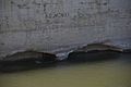
Intake where water is diverted from the Owens River
-

Water entering the aqueduct at its northern end
-
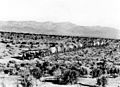
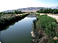
The Los Angeles Aqueduct in Antelope Valley
-
Holt tractors working during the first aqueduct's construction in 1909
-
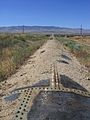
An unlined part of the Los Angeles Aqueduct, near Manzanar
-
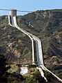
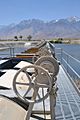
The Terminal Structure and penstock above the new Cascades on the Los Angeles Aqueduct
-
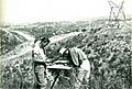
Surveyors mapping the land for the Second Los Angeles Aqueduct.
-
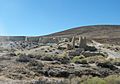
Ruins of the Fairmont Mill, one of three mills that made cement for the Los Angeles Aqueduct.
-
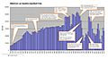
Chart showing water imports through the Los Angeles Aqueduct system from 1913 to 2011.
-
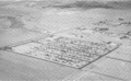
Shangri-La Estates in Ridgecrest, CA provided temporary homes during the Second Los Angeles Aqueduct's construction.
-
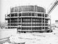
Building the Terminal Structure above the Second Los Angeles Aqueduct cascade.
-
Pouring concrete for the Terminal Structure above the Second Los Angeles Aqueduct cascade.


.jpg)


Images for kids
-
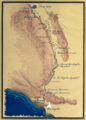
Los Angeles Aqueduct System, 1971
-
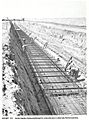
Construction of the Second Los Angeles Aqueduct.
-
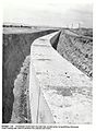
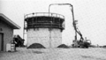
Finished concrete box on the Los Angeles Aqueduct.


See also
 In Spanish: Acueducto de Los Ángeles para niños
