
Mulholland Drive facts for kids

Map of Mulholland Drive (orange) and Mulholland Highway (brown) in Los Angeles County
|
|
| Namesake | William Mulholland |
|---|---|
| Maintained by | Bureau of Street Services, City of L.A. DPW |
| Length | 21 mi (34 km) |
| West end | |
| Major junctions |
|
| East end | |

Mulholland Drive is a famous road in the Santa Monica Mountains of Southern California. It is named after William Mulholland, a very important engineer in Los Angeles history. He helped bring water to the city.
The western part of the road, which is more rural, is called Mulholland Highway. This road has appeared in many movies, songs, and books. A famous director, David Lynch, even made a film named after it. He once said that you can feel "the history of Hollywood" when you are on Mulholland Drive. Many famous people have lived along this scenic route.
Contents
Exploring Mulholland Drive
Mulholland Drive is a long road that winds through the hills. It offers amazing views of the city and the valleys around it.
A Road with a View
The road is about 21 miles (34 kilometers) long. It mostly has two lanes and follows the top of the eastern Santa Monica Mountains. It connects two parts of U.S. Route 101. Along the way, it crosses several other important streets like Sepulveda Boulevard and Laurel Canyon Boulevard.
From Mulholland Drive, you can see many famous sights. These include the Los Angeles Basin, the San Fernando Valley, Downtown Los Angeles, and the iconic Hollywood Sign. It's a great spot for taking pictures!
Homes of the Stars
Some of the most expensive and exclusive homes in the world are found on Mulholland Drive. Many Hollywood celebrities live in these beautiful houses.
History of Mulholland Drive
This famous road has a long and interesting past. It was built to connect different parts of the growing city.
Building the Scenic Route
The main part of Mulholland Drive opened in 1924. It stretched from Cahuenga Pass in Hollywood westward past Sepulveda Pass. A group of businesses and people who owned land in the Hollywood Hills helped build it. They wanted to create a beautiful road for everyone to enjoy.
DeWitt Reaburn, the engineer in charge, believed it would become one of the most popular and well-known scenic roads in the United States. He was right!
Road Closures and Repairs
Over the years, Mulholland Drive has sometimes closed because of bad weather. Heavy rains can cause mudslides and damage the road. For example, there was a closure in 2024 due to storm damage. Workers always fix the road quickly so people can enjoy it again.
The Route of Mulholland Drive
Let's take a closer look at where Mulholland Drive starts and ends, and what you can see along the way.
Starting in Hollywood
Mulholland Drive begins in the Hollywood Hills. Its eastern end is where it meets Cahuenga Boulevard at the Cahuenga Pass. From here, the road heads west. You can see the Hollywood Sign and the tall buildings of Downtown Los Angeles. You can also spot cities like Burbank and Universal City in the San Fernando Valley. In the distance, you might see the San Gabriel Mountains.
"Dirt Mulholland" and Beyond
The road continues to wind along the mountaintops. A few miles west of the Interstate 405 Freeway, the paved road ends. Here, it becomes an unpaved path that cars cannot use. This section is often called "Dirt Mulholland." It's a popular spot for hiking and biking. This part of the road also leads to an old Cold War memorial park. This section was closed to cars to protect the natural beauty of the area.
Where the Road Ends
Mulholland Drive becomes paved again east of Topanga Canyon Boulevard. Soon after, the road splits into Mulholland Drive and Mulholland Highway. Mulholland Drive eventually ends at U.S. Highway 101 (the Ventura Freeway). From there, it turns into Valley Circle Boulevard.
Mulholland Highway continues southwest. It finally ends at State Route 1 (Pacific Coast Highway) near the Pacific Ocean. This is close to Leo Carrillo State Park, on the border of Los Angeles and Ventura counties.
Images for kids
-
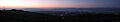
View at dusk from Mulholland Drive across the southeast San Fernando Valley
-
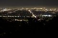
San Fernando Valley at night from Mulholland Drive
-
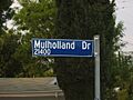
A Mulholland Drive street sign in a residential neighborhood in Woodland Hills.


See also
 In Spanish: Mulholland Drive para niños
