
Interstate 405 (California) facts for kids
Quick facts for kids
|
||||
|---|---|---|---|---|
| San Diego Freeway | ||||
| Lua error in Module:Infobox_road/map at line 15: attempt to index field 'wikibase' (a nil value).
I-405 highlighted in red
|
||||
| Route information | ||||
| Auxiliary route of I-5 | ||||
| Defined by S&HC § 615 | ||||
| Maintained by Caltrans | ||||
| Length | 72.415 mi (116.541 km) | |||
| Existed | 1964–present | |||
| Major junctions | ||||
| South end | ||||
|
||||
| North end | ||||
| Location | ||||
| Counties: | Orange, Los Angeles | |||
| Highway system | ||||
| Auxiliary route of the Interstate Highway System Main • Auxiliary • Business State highways in California(list • pre-1964)
|
||||
.svg)
Interstate 405 (I-405) is a very important highway in California. It runs through Orange and Los Angeles counties. This highway is a special kind of road called a "spur route." This means it connects to a bigger highway, Interstate 5, at both its start and end points.
The I-405 starts near San Fernando in the north. It then travels south through the western part of Los Angeles and Long Beach. Finally, it connects back to Interstate 5 near Irvine in the south. It is known as the busiest highway in the United States. This is mainly because it's the only major north-south highway on the west side of Los Angeles. It also passes by very important places like Los Angeles International Airport (LAX) and the large ports of Los Angeles and Long Beach.
Contents
What is Interstate 405?
Interstate 405, often called the San Diego Freeway, is part of the Interstate Highway System. This system is a network of highways that connect different states across the U.S. I-405 is an "auxiliary" Interstate. This means it's a branch off a main Interstate, which in this case is I-5.
How Long is I-405?
The I-405 stretches for about 72.4 miles (116.5 kilometers). It was officially opened in 1964. It helps millions of people travel every day for work, school, and fun.
Why is I-405 so Busy?
The I-405 is famous for its heavy traffic. One main reason is its location. It's the only major highway that goes north and south through the western part of Los Angeles. This area is home to many people and businesses. Because of this, many drivers use I-405 to get around.
Important Places Along I-405
The highway connects to many important cities and landmarks. As you travel along I-405, you'll see signs for various places.
- Los Angeles International Airport (LAX): This is one of the busiest airports in the world. I-405 provides direct access to it.
- Port of Los Angeles and Port of Long Beach: These are two of the largest and busiest seaports in the United States. They handle a huge amount of goods coming into and leaving the country.
- Major cities: The freeway passes through many cities. These include Irvine, Costa Mesa, Long Beach, Carson, and parts of Los Angeles.
Connecting Freeways
I-405 connects with many other major freeways in Southern California. These connections help drivers reach different parts of the region. Some of the main connections include:
- Interstate 5 (I-5): The main Interstate that I-405 branches off from.
- California State Route 133 (SR 133)
- California State Route 55 (SR 55)
- California State Route 73 (SR 73)
- Interstate 605 (I-605)
- California State Route 22 (SR 22)
- Interstate 710 (I-710)
- Interstate 110 (I-110)
- Interstate 105 (I-105)
- Interstate 10 (I-10)
- California State Route 2 (SR 2)
- U.S. Route 101 (US 101)
- California State Route 118 (SR 118)
These connections make I-405 a central part of the transportation system in Southern California.
Images for kids
-
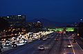
The Bristol exit near South Coast Plaza and Segerstrom Center for the Arts, with Saddleback in the background
-
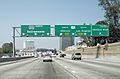
I-405 near the interchange with the Ventura Freeway (U.S. Route 101)
-
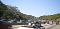
I-405 in the Sepulveda Pass
-
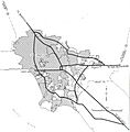
1955 map of the planned Interstates in the Los Angeles area; present-day I-405 roughly corresponds to the 1955 proposed route through the western regions of the area.
-
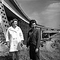
Civil engineers Marilyn Reece and Carol Schumaker, at the Reece-designed I-10/I-405 interchange, 1964
-
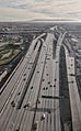
Aerial view from the north of I-405's interchange with I-105 near Los Angeles International Airport from directly above Arbor Vitae Street; the hills of the Palos Verdes Peninsula are visible in the distance
_01.JPG)


See also
 In Spanish: Interestatal 405 (California) para niños
