
Westwood, Los Angeles facts for kids
Quick facts for kids
Westwood
|
|
|---|---|
  .jpg) .jpg) Top: Westwood Boulevard; Fox Bruin Theater; bottom: Sheats Apartments; Kelton Apartments.
|
|

Westwood neighborhood as delineated by the Los Angeles Times. LDS (Mormon) Temple in red.
|
|

Westwood
Location in Western Los Angeles
|
|
| Country | United States |
| State | California |
| County | Los Angeles |
| City | Los Angeles |
| Elevation | 338 ft (103 m) |
| Population | 50,288 |
| Population of ZIP Code 90024, grossly corresponding to Westwood, American Community Survey, U.S. Census Bureau, 2018 | |
| Time zone | UTC−8 (PST) |
| • Summer (DST) | UTC−7 (PDT) |
| ZIP Codes |
90024, 90025, 90049
|
| Area code(s) | 310/424 |


.jpg)


Westwood is a lively neighborhood in Los Angeles, California. It's located in the central part of the city's Westside region. Westwood is famous for being home to the University of California, Los Angeles (UCLA).
Right next to the UCLA campus, you'll find Westwood Village. This area is a popular spot for shopping, eating at restaurants, watching movies, and enjoying other fun activities. Along Wilshire Boulevard in Westwood, there are many tall buildings, including apartments and offices. Westwood also has quiet areas with houses, like the fancy Holmby Hills. The neighborhood began to be built in 1919, and UCLA opened its doors in 1929. Westwood Village grew quickly in the 1930s.
Exploring Westwood's Location
Westwood is surrounded by other well-known areas in Los Angeles. To the north, you'll find Sunset Boulevard and Beverly Crest. To the east, it borders Beverly Hills. South of Westwood is Santa Monica Boulevard and West Los Angeles. On the west, it's next to the San Diego Freeway and Brentwood. Bel-Air is to the northwest.
Westwood's Story: How It Grew
How Westwood Was Built
Westwood was once a large piece of land called the Wolfskill Ranch, covering about 3,000 acres. In 1919, a successful businessman named Arthur Letts, who founded famous department stores like The Broadway and Bullock's, bought this land.
After Arthur Letts passed away, his son-in-law, Harold Janss, took over. He worked for the Janss Investment Company. Harold Janss started to develop the area and advertised new homes in 1922. The Los Angeles Times newspaper shared the exciting news, saying that Westwood was opening up for people to buy homes and invest.
UCLA's Arrival in Westwood
At the same time, a branch of the University of California was growing very fast on Vermont Avenue in Los Angeles. By 1925, it needed a much bigger space. On March 21, 1925, it was announced that a new campus would be built in the Westwood hills.
The Janss brothers, who owned the land, agreed to sell it for about $1 million. This was much less than the land was actually worth! Cities like Los Angeles, Santa Monica, Beverly Hills, and Venice helped pay for it with special bonds. Another state bond provided $3 million for new buildings. This is how the University of California, Los Angeles (UCLA) came to be in Westwood, opening its new campus in 1926.
Who Lives in Westwood?
In 2018, about 50,288 people lived in the Westwood area. This number comes from the U.S. Census Bureau. The neighborhood is about 3.68 square miles, meaning there are about 13,036 people per square mile. This is an average number for Los Angeles.
Westwood is known for having a mix of different cultures. Many people are from Asian backgrounds or are white. About 31.3% of residents were born outside the U.S., with many coming from Iran and Taiwan.
The average yearly income for households in Westwood was about $68,716 in 2008. Many people rent their homes (64.1%), while others own them (35.9%). Westwood also has a high percentage of young adults, especially those aged 19 to 34.
Fun Places and Culture in Westwood
Besides all the cool things at UCLA, Westwood has many other places for fun and learning:
Historic Movie Theaters
Westwood Village is home to two old movie theaters that have a lot of history. The Fox Village Theater opened in 1931. The Bruin Theater opened in 1937. Both theaters have hosted many famous Hollywood movie premieres over the years.
Hammer Museum: Art and Ideas
The Hammer Museum is connected to UCLA. It's an art museum and cultural center known for its interesting art shows and public events. The museum was started in 1990 by Armand Hammer to show his own art collection. Now, it's known for showing works by both famous and new artists. The Hammer Museum also holds over 300 events each year, like talks, readings, concerts, and movie screenings. Since 2014, it's completely free to visit!
Geffen Playhouse Theater
The Geffen Playhouse Theater was built in 1929. It was first a club for UCLA students and alumni. It was one of the first buildings in Westwood Village.
LDS (Mormon) Temple
The Los Angeles California Temple is a very large temple operated by The Church of Jesus Christ of Latter-day Saints. It's located on Santa Monica Boulevard in Westwood. The temple grounds also have a Visitors' Center that anyone can visit. The church bought the land for the temple in 1937 from silent film star Harold Lloyd. The temple opened in 1956.
The temple grounds also have the Los Angeles Regional Family History Center. This center is open to the public and helps people learn about their family history. It's one of the largest centers of its kind, with many old records and books.
-
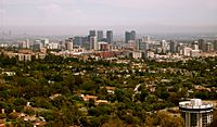
A view of Westwood and the surrounding areas in 2007.
-
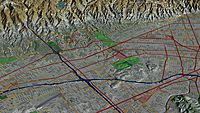
An aerial view of Westwood (center) from a 3D computer image.
-
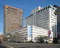
The Hammer Museum in 2007.
-
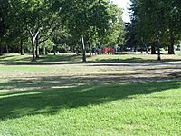
Westwood Park in 2012.


Parks and Outdoor Fun
Westwood has great places for outdoor activities. The Westwood Recreation Center has barbecue pits, a lighted baseball field, basketball courts, and racquetball courts. There's also a playground for kids, a community room, and a gym.
A special part of the center is Aidan's Place, which opened in 2001. This playground was designed for all children, including those who use wheelchairs, so everyone can play together.
Holmby Park is another beautiful park located in Westwood.
Learning in Westwood
Westwood is a very educated community. By 2000, about 66% of adults aged 25 and older had a four-year college degree. Many also had a master's degree or higher.
The most famous school in Westwood is the University of California, Los Angeles (UCLA).
The Los Angeles Unified School District runs public schools in the area. Some of the schools in Westwood include:
- Fairburn Avenue Elementary School, 1403 Fairburn Avenue
- Warner Avenue Elementary School, 615 Holmby Avenue
- Westwood Charter Elementary School, 2050 Selby Avenue
- Sinai Akiba Academy, a private elementary school, 10400 Wilshire Boulevard
- Saint Paul the Apostle, a private elementary school, 1536 Selby Avenue
- Ralph Waldo Emerson Middle School, 1660 Selby Avenue
Students in this area usually go to University High School in West Los Angeles.
The UCLA Lab School Corinne A. Seeds Campus is a special school connected to UCLA. It was renamed in 2009.
-

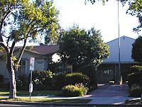
Fairburn Avenue School.
-
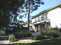
Warner Avenue School.
-
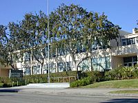
Westwood Elementary School.
-
Emerson Middle School.
-
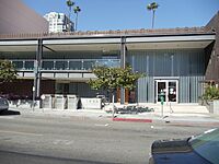
The Westwood Branch Library.


The Los Angeles Public Library opened a branch in Westwood in 2005, giving residents a great place to read and learn.
Famous People from Westwood
- Andy Hill (born around 1950), a college basketball player and business executive.
- Emma Stone, a well-known actress.
See also
 In Spanish: Westwood (Los Ángeles) para niños
