
Irvine, California facts for kids
Quick facts for kids
Irvine, California
|
|||||||||||||||
|---|---|---|---|---|---|---|---|---|---|---|---|---|---|---|---|
|
Charter city
|
|||||||||||||||
|
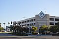
Irvine Civic Center
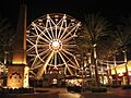
"Giant Wheel" at Irvine Spectrum Center
Balloon ride at Orange County Great Park
|
|||||||||||||||
|
|||||||||||||||
| Country | United States | ||||||||||||||
| State | California | ||||||||||||||
| County | Orange | ||||||||||||||
| Incorporated | December 28, 1971 | ||||||||||||||
| Named for | James Irvine | ||||||||||||||
| Government | |||||||||||||||
| • Type | Council–manager | ||||||||||||||
| • Body | Irvine City Council | ||||||||||||||
| Area | |||||||||||||||
| • Total | 65.92 sq mi (170.74 km2) | ||||||||||||||
| • Land | 65.61 sq mi (169.94 km2) | ||||||||||||||
| • Water | 0.31 sq mi (0.80 km2) 0.52% | ||||||||||||||
| Elevation | 56 ft (17 m) | ||||||||||||||
| Population
(2020)
|
|||||||||||||||
| • Total | 307,670 | ||||||||||||||
| • Rank | (2023) 2nd in Orange County 13th in California 63rd in the United States |
||||||||||||||
| • Density | 4,689.1/sq mi (1,810.46/km2) | ||||||||||||||
| Time zone | UTC−08:00 (Pacific) | ||||||||||||||
| • Summer (DST) | UTC−07:00 (PDT) | ||||||||||||||
| ZIP Codes |
92602–92604, 92606, 92612, 92614, 92616–92620, 92623, 92650, 92697
|
||||||||||||||
| Area codes | 949, 657/714 | ||||||||||||||
| FIPS code | 06-36770 | ||||||||||||||
| GNIS feature IDs | 1660804, 2410116 | ||||||||||||||
| Sphere of influence | 74 miles (119 km) | ||||||||||||||
|
|||||||||||||||


.jpg)


Irvine is a special kind of city called a master-planned city. It is located in the middle of Orange County, California, in the Los Angeles metropolitan area. The Irvine Company started building the city in the 1960s. Irvine officially became a city on December 28, 1971.
This city covers about 66 square miles (170.74 km2). In 2020, about 307,670 people lived here. As of 2023, Irvine is the second largest city in Orange County. It is also the 13th largest city in California and the 63rd largest in the whole United States.
Many big companies, especially in technology, have their main offices in Irvine. It is also home to several colleges and universities. These include the University of California, Irvine (UCI), Concordia University, and Irvine Valley College.
Contents
History of Irvine
Irvine has a long and interesting history! About 2,000 years ago, the Gabrieleño people lived in this area. In 1769, a Spanish explorer named Gaspar de Portolà arrived. This led to the Spanish building forts and missions, and bringing cattle. The King of Spain then gave out land for these missions and for private use.
After Mexico became independent from Spain in 1821, the Mexican government took over the mission lands. They started giving this land to Mexican citizens. Three large Spanish/Mexican land grants, or "ranchos," made up the land that later became the Irvine Ranch. These were Rancho Santiago de Santa Ana, Rancho San Joaquin, and Rancho Lomas de Santiago.
In 1864, Jose Andres Sepulveda, who owned Rancho San Joaquin, sold a huge part of his land (50,000 acres) to some businessmen for $18,000. He did this to pay off debts from a big drought. In 1866, these businessmen bought another large ranch. After the Mexican-American War, the land of Rancho Santiago de Santa Ana was divided among three people, including James Irvine. At first, these ranches were used for raising sheep. But by 1870, people were allowed to farm the land.
In 1878, James Irvine bought out his partners. His ranch grew to 110,000 acres, stretching 23 miles from the Pacific Ocean to the Santa Ana River. When James Irvine died in 1886, his son, James Irvine II, took over. He turned the ranch into the Irvine Company. James Irvine II changed the ranch's focus to growing crops like olives and citrus fruits.
In 1888, a railroad line was built, and a station was named after James Irvine. The small town that grew around this station was first called Myford, after Irvine's son. This was because another town already had the Irvine name. But in 1914, the town was renamed Irvine.
By 1918, a huge amount of land (60,000 acres) on the Irvine Ranch was used to grow lima beans. During World War II, the Irvine Company sold some land to the government for two Marine Corps bases: MCAS El Toro and MCAS Tustin.
James Irvine II passed away in 1947. His son, Myford, became the head of the Irvine Company. He started to open up parts of the Irvine Ranch for building new homes and businesses.
The Irvine Ranch was even used for the Boy Scouts of America's 1953 National Scout Jamboree. A major street, Jamboree Road, was named after this event.
Myford Irvine died in 1959. That same year, the University of California asked the Irvine Company for 1,000 acres for a new university campus. The Irvine Company sold this land for just $1! Later, the state bought another 500 acres.
William Pereira, an architect, and the Irvine Company planners created a big plan for a city of 50,000 people around the new university. This plan included areas for businesses, homes, parks, and shopping centers. The new community was named Irvine. The old farming town of Irvine, with the railroad station, was renamed East Irvine. By 1970, the first parts of new "villages" like Turtle Rock and University Park were finished.
On December 28, 1971, the people living in these communities voted to make Irvine an official city. By 1999, Irvine had 134,000 people and covered 43 square miles.
In 2003, after a long legal fight, Irvine added the land from the former El Toro Marine Corps Air Station to its city limits. This added 7.3 square miles of land. It also stopped plans for a new airport there. Instead, the Orange County Great Park was built on this land.
Geography of Irvine
Irvine is located in a great spot in California. It shares borders with several other cities. To the north is Tustin, and to the northwest is Santa Ana. To the east and southeast, you'll find Lake Forest. Laguna Hills and Laguna Woods are to the south, and Costa Mesa is to the west. Newport Beach is to the southwest. Irvine also has a small border with Orange in the north.
The main waterway that drains the city is San Diego Creek. It flows northwest into Upper Newport Bay. Most of Irvine is in a wide, flat valley. This valley is between Loma Ridge in the north and San Joaquin Hills in the south. However, in the far northern and southern parts of the city, there are some hills, flat areas, and canyons.
Irvine as a Planned City
Irvine's design was created by architect William Pereira and Raymond Watson from the Irvine Company, starting in the late 1950s. The city is divided into areas called "villages." These villages are separated by wide, six-lane roads. Each village has homes with similar designs, along with shops, places of worship, and schools. Business areas are located around the edges of these central villages. The city was designed mainly for cars, which means it is very car dependent today.
Pereira first thought about putting the university campus at the northern end of the Irvine Ranch. But the Irvine Company didn't want to give up valuable farmland there. So, the university was moved to the base of the southern coastal hills. The city's layout looks like a necklace, with the villages strung along two main streets that end at University of California, Irvine (UCI). Residential areas are now next to two business districts: the Irvine Business Complex to the west and Irvine Spectrum to the east.
All streets in Irvine have special areas for landscaping. Paths for power lines are also used as bike paths, parks, and green spaces. These green areas connect different nature preserves. The city uses recycled water to keep all this greenery watered.
Some neighborhoods have homeowners' associations. These groups control how homes look, including roofing, paint colors, and landscaping. Older parts of Northwood, built in the 1970s, do not have these associations. Villages with more rules often have more benefits, like private swimming pools, tennis courts, and parks for their members.
Irvine's Villages
Each of Irvine's villages was originally planned to have its own special building style.
- El Camino Glen
- College Park
- The Colony
- Columbus Grove
- Cypress Village
- Deerfield (mixed styles)
- East Irvine
- El Camino Real (Spanish/Neo-Eclectic)
- Greentree
- Irvine Groves
- Harvard Square
- Heritage Fields
- Laguna Altura
- Lambert Ranch
- Northpark (French Country, Formal French, Italian Country, Formal Italian, Monterey and Spanish Colonial)
- Northpark Square (Spanish Mission)
- Northwood (Bungalow, Craftsman)
- Oak Creek (mixed styles)
- Old Towne Irvine
- Orangetree
- Orchard Hills (Rural Craftsman/Spanish/Tuscan)
- Park Lane
- Parkcrest
- Parkside
- Pavilion Park
- Portola Springs (Spanish/Tuscan)
- Planning Area 40 (Future Village)
- Quail Hill (Spanish/Tuscan)
- Racquet Club
- The Ranch
- Rancho San Joaquin (Shed style)
- Rosegate (Spanish/Tuscan)
- San Marino (Spanish/Tuscan)
- Stonegate (Spanish)
- Shady Canyon (Tuscan Ranch)
- Turtle Ridge (Tuscan)
- Turtle Rock (mixed styles)
- University Hills
- University Park (California Modern)
- University Town Center (mixed styles)
- Walnut (Prairie Style)
- West Irvine (California Modern)
- Westpark (Italian Riviera/Mediterranean)
- The Willows
- Windwood
- Woodbridge (Atlantic Coast)
- Woodbury (Tuscan/Spanish/French)
- Woodbury East (Spanish)
Business and commercial areas
- Irvine Business Complex
- Irvine Spectrum (Contemporary/Moroccan)
- Old Town Irvine
Irvine's Climate
Irvine has a Mediterranean climate, which means it has mild, wet winters and warm, dry summers. In late spring and early summer, Irvine often experiences "June Gloom." This is when mornings are cloudy, and sometimes there's a light drizzle.
Late summer and autumn are usually warm and dry. Sometimes, humid weather from Pacific hurricanes off Mexico can reach the area. Winters are mild, and it rarely freezes. It can get hot and dry when the Santa Ana winds blow.
Because Irvine is close to the coast, different parts of the city can have slightly different weather. For example, the "June Gloom" is stronger in the southern parts of Irvine, closer to the ocean.
It can sometimes snow in the Santa Ana Mountains northeast of Irvine. Snow in the lower parts of Irvine is very rare. However, the area did get three inches of snow in January 1949. A tornado even touched down in Irvine in 1991! Tornadoes happen in Orange County about once every five years.
| Climate data for Irvine Ranch, Irvine, California (1991–2020 normals) | |||||||||||||
|---|---|---|---|---|---|---|---|---|---|---|---|---|---|
| Month | Jan | Feb | Mar | Apr | May | Jun | Jul | Aug | Sep | Oct | Nov | Dec | Year |
| Record high °F (°C) | 94 (34) |
92 (33) |
98 (37) |
106 (41) |
105 (41) |
109 (43) |
109 (43) |
110 (43) |
111 (44) |
108 (42) |
105 (41) |
97 (36) |
111 (44) |
| Mean daily maximum °F (°C) | 69.0 (20.6) |
70.5 (21.4) |
73.1 (22.8) |
76.4 (24.7) |
79.4 (26.3) |
82.5 (28.1) |
88.1 (31.2) |
90.2 (32.3) |
88.8 (31.6) |
84.2 (29.0) |
75.6 (24.2) |
67.8 (19.9) |
78.8 (26.0) |
| Daily mean °F (°C) | 58.8 (14.9) |
59.2 (15.1) |
61.4 (16.3) |
64.1 (17.8) |
67.6 (19.8) |
70.6 (21.4) |
75.0 (23.9) |
76.2 (24.6) |
75.3 (24.1) |
71.1 (21.7) |
64.0 (17.8) |
57.7 (14.3) |
66.7 (19.3) |
| Mean daily minimum °F (°C) | 48.6 (9.2) |
47.9 (8.8) |
49.7 (9.8) |
51.9 (11.1) |
55.5 (13.1) |
58.7 (14.8) |
61.9 (16.6) |
62.2 (16.8) |
61.7 (16.5) |
57.8 (14.3) |
52.5 (11.4) |
47.6 (8.7) |
54.7 (12.6) |
| Record low °F (°C) | 18 (−8) |
25 (−4) |
26 (−3) |
31 (−1) |
34 (1) |
40 (4) |
44 (7) |
43 (6) |
39 (4) |
29 (−2) |
25 (−4) |
24 (−4) |
18 (−8) |
| Average rainfall inches (mm) | 2.67 (68) |
3.47 (88) |
1.70 (43) |
0.85 (22) |
0.34 (8.6) |
0.04 (1.0) |
0.09 (2.3) |
0.01 (0.25) |
0.10 (2.5) |
0.62 (16) |
0.83 (21) |
2.34 (59) |
13.06 (331.65) |
| Average rainy days (≥ 0.01 in) | 4.1 | 4.1 | 3.0 | 2.2 | 1.6 | 0.2 | 0.3 | 0.1 | 0.4 | 1.9 | 2.4 | 4.2 | 24.5 |
| Source: NOAA | |||||||||||||
Irvine's Population and People
Irvine has grown a lot over the years! Here's how its population has changed:
| Historical population | |||
|---|---|---|---|
| Census | Pop. | %± | |
| 1970 | 10,081 | — | |
| 1980 | 62,127 | 516.3% | |
| 1990 | 110,330 | 77.6% | |
| 2000 | 143,072 | 29.7% | |
| 2010 | 212,375 | 48.4% | |
| 2020 | 307,670 | 44.9% | |
| 2023 (est.) | 314,621 | 48.1% | |
| U.S. Decennial Census | |||
Irvine is a very diverse city, with people from many different backgrounds. The tables below show the racial and ethnic makeup of Irvine based on the US Census.
| Historical racial profile | 1980 | 1990 | 2000 | 2010 | 2020 |
|---|---|---|---|---|---|
| White | 87.8% | 77.9% | 61.1% | 50.5% | 37.7% |
| —Non-Hispanic | 84.5% | 73.9% | 57% | 45.1% | 34.5% |
| Black or African American | 1.5% | 1.8% | 1.5% | 1.8% | 2.2% |
| Hispanic or Latino (of any race) | 5.8% | 6.3% | 7.4% | 9.2% | 11.7% |
| Asian | 7.8% | 18.1% | 29.8% | 39.2% | 45.4% |
| Two or more races | n/a | n/a | 5.4% | 5.5% | 9.7% |
Population in 2020
| Race / Ethnicity (NH = Non-Hispanic) | Pop 2000 | Pop 2010 | Pop 2020 | % 2000 | % 2010 | % 2020 |
|---|---|---|---|---|---|---|
| White alone (NH) | 81,613 | 95,822 | 106,056 | 57.04% | 45.12% | 34.47% |
| Black or African American alone (NH) | 1,977 | 3,494 | 6,646 | 1.38% | 1.65% | 2.16% |
| Native American or Alaska Native alone (NH) | 162 | 199 | 285 | 0.11% | 0.09% | 0.09% |
| Asian alone (NH) | 42,506 | 82,722 | 139,725 | 29.71% | 38.95% | 45.41% |
| Pacific Islander alone (NH) | 180 | 295 | 341 | 0.13% | 0.14% | 0.11% |
| Other race alone (NH) | 359 | 554 | 1,790 | 0.25% | 0.26% | 0.58% |
| Mixed race or Multiracial (NH) | 5,736 | 9,668 | 16,972 | 4.01% | 4.55% | 5.52% |
| Hispanic or Latino (any race) | 10,539 | 19,621 | 35,855 | 7.37% | 9.24% | 11.65% |
| Total | 143,072 | 212,375 | 307,670 | 100.00% | 100.00% | 100.00% |
Population in 2010
The 2010 United States Census showed that Irvine had 212,375 people. About 96.9% of these people lived in homes. The city was made up of 50.5% White, 1.8% African American, 0.2% Native American, 39.2% Asian, and 0.2% Pacific Islander people. About 2.8% were from other races, and 5.5% were from two or more races. People of Hispanic or Latino background made up 9.2% of the population.
There were 78,978 households. About 33.8% of these had children under 18. The average household had 2.61 people. The average family had 3.13 people.
The population's age spread was: 21.5% under 18, 14.3% aged 18 to 24, 31.4% aged 25 to 44, 24.1% aged 45 to 64, and 8.7% aged 65 or older. The average age was 33.9 years.
In 2009–2013, the average household income in Irvine was $90,585. About 12.2% of the people lived below the poverty line. Housing in Irvine can be expensive.
Population in 2000
The census of 2000 found 143,072 people living in Irvine. There were 51,199 households and 34,354 families. The city's population density was about 3,098 people per square mile.
The racial makeup was 61.1% White, 7.4% Hispanic or Latino, 1.5% Black or African American, 0.2% Native American, 29.8% Asian, and 1.1% Pacific Islander. About 2.5% were from other races, and 4.8% were from two or more races.
About 36.0% of households had children under 18. The average household size was 2.70 people, and the average family size was 3.17.
The population's age spread was: 23.5% under 18, 14.4% from 18 to 24, 32.3% from 25 to 44, 22.6% from 45 to 64, and 7.2% who were 65 or older. The average age was 33 years.
In 2007, the average income for a household in Irvine was $98,923. For families, it was $111,455. This made Irvine one of the richest cities in the U.S. for cities with over 65,000 people.
Irvine's Economy
Irvine is a very important city for business and jobs. The Destination Irvine program helps share information about Irvine as a great place to visit or to hold business meetings. Irvine has been named one of the best cities for new businesses. Its strong and growing economy has helped Orange County become one of the fastest-growing job markets.
Irvine is also used as a place for filming movies and TV shows. The city government offers free or low-cost permits for filming.
Top Employers in Irvine
Irvine has many large employers. Here are some of the biggest ones:
| # | Employer | Employees (2023) | Industry | HQ |
|---|---|---|---|---|
| 1 | University of California, Irvine | 27,216 | Education | |
| 2 | Peraton State & Local Inc. | 17,000 | ||
| 3 | Irvine Unified School District | 3,979 | Education | |
| 4 | Mastec Norther America Inc | 3,395 | ||
| 5 | Edwards Lifesciences | 3,272 | Healthcare | |
| 6 | Digital Insurance Inc. | 2,603 | ||
| 7 | Blizzard Entertainment | 2,327 | Gaming | |
| 8 | SA Recycling LLC | 2,000 | ||
| 9 | B.Braun | 1,910 | Healthcare | |
| 10 | Center for Autism | 1,910 | Healthcare |
Businesses in Irvine
Many companies have their main offices in Irvine. Here are some of them:
- Allergan, Inc.
- Alteryx
- BAX Global
- Blizzard Entertainment
- Broadcom Corporation
- CalAmp
- CoreLogic
- CorVel Corporation
- Cylance
- Edwards Lifesciences
- Epicor Software Corporation
- Felt Bicycles
- Ford Motor Company (West Coast design center)
- Gateway, Inc.
- Golden State Foods
- HID
- Ingram Micro
- In-N-Out Burger
- K2 Network
- Karma Automotive
- Kelley Blue Book (subsidiary of Cox Automotive)
- Kofax
- LA Fitness
- Lifted Research Group
- Maruchan, Inc. (a division of Toyo Suisan)
- Masimo
- MindFire, Inc
- NextGen Healthcare
- Obsidian Entertainment
- Paragon Software Group
- Panasonic Avionics Corporation
- Pacific Dental Services
- Pacific Premier Bank
- Point of View, Inc.
- Premier Office Centers
- Printronix
- Quicksilver Software
- Razer
- Red Digital Cinema Camera Company
- Rivian
- Ruby's Diner
- Skyworks Solutions
- St. John
- Stüssy
- Super73
- Superformance, LLC
- Taco Bell (a division of Yum! Brands, Inc.)
- The Habit Burger Grill
- Tillys
- Ultimate Ears
- Vizio
- W. Brown & Associates
- Western Mutual Insurance Group
- Wimberly Allison Tong & Goo (WATG)
- Xumo
- Yogurtland
Many international companies also have their North American headquarters in Irvine:
- Asics
- Atlus
- Bandai Namco Entertainment (American division)
- Bandai Namco Holdings (American division)
- BenQ Corporation
- BSH Bosch und Siemens Hausgeräte GmbH
- Dahua Technology
- Fisher & Paykel Healthcare
- Horiba
- Kia Motors
- KOG Games
- Marukome
- Mazda Motor Corporation
- Nikken Sekkei
- Samsung Electronics (IT and printing division)
- Sega (American division)
- Shimano
- TCL Technology
- Toshiba Corporation
Arts and Culture in Irvine
Irvine has a lively arts and culture scene!
The Irvine Global Village Festival
Every October, Irvine holds the Irvine Global Village Festival. This festival celebrates the many different cultures of people living in Irvine and Orange County. You can find exhibits from local shops, enjoy entertainment from various cultures, and try foods from all over the world. The festival takes place at the Orange County Great Park.
Irvine Community Television
Irvine Community Television (ICTV) creates and broadcasts TV shows for the Irvine community. These shows cover news, sports, arts, culture, and safety. ICTV's motto is "For You, About You." You can watch ICTV on Cox Communications channel 30 and online.
Libraries in Irvine
Irvine has three public libraries: Heritage Park Regional Library, University Park Library, and Katie Wheeler Library. The Heritage Library is a main reference library for Central Orange County, focusing on business and art. The University Park Library has many books, including a large collection in Chinese. The Katie Wheeler Library is a copy of the house where James Irvine's granddaughter, Katie Wheeler, grew up. Also, most UCI Libraries are open for public use.
Points of Interest in Irvine
There are many interesting places to visit in Irvine:
- Ayn Rand Institute
- California State University Fullerton, Irvine Campus
- Concordia University, Irvine
- Fashion Institute of Design and Merchandising, Orange County Campus
- Heritage Park
- Irvine Spectrum Center
- Irvine Valley College
- Islamic Center of Irvine
- Mariners Church
- Mason Park
- Northwood Gratitude and Honor Memorial
- Pao Fa Temple
- Saddleback Church, Irvine Campuses
- The Market Place
- University of California, Irvine, Arboretum
Sports in Irvine
Irvine is an important center for sports. It is home to USA Water Polo, which is the main organization for the sport of water polo in the United States.
Irvine also has its own professional soccer team, Orange County SC. They play in the USL Championship league. Their home games are held at Championship Soccer Stadium, which is located inside the Great Park.
Parks and Recreation in Irvine
Irvine has many parks for everyone to enjoy. Community parks have public facilities, while neighborhood parks offer open spaces and fun activities within the different villages.
Northwood Community Park is home to the Northwood Gratitude and Honor Memorial. This memorial honors U.S. soldiers who died in the Iraq War and the War in Afghanistan. It was the first memorial in the United States built before these wars ended.
Other great parks in Irvine include:
- Aldrich Park: A 19-acre park at the UC Irvine campus. It marks the center of the planned city.
- Jeffrey Open Space Trail
- San Joaquin Wildlife Sanctuary
- William R. Mason Regional Park
Education in Irvine
Irvine is known for its excellent schools and colleges.
Primary and Secondary Education
Most of Irvine is part of the Irvine Unified School District (IUSD). There are five high schools in IUSD: University High School, Irvine High School, Northwood High School, Woodbridge High School, and Portola High School. Arnold O. Beckman High School is also in Irvine but is managed by the Tustin Unified School District. All these high schools are often ranked among the top public high schools in the U.S.
Irvine also has private high schools like Crean Lutheran High School (a Lutheran school) and Tarbut V' Torah (a Jewish day school).
The city has many elementary and middle schools. Some parts of northern and western Irvine are in the Tustin Unified School District. A very small part of the city, near Orange County Great Park, is in the Saddleback Valley Unified School District. The southwest part of Irvine, near John Wayne International Airport, is in the Santa Ana Unified School District.
Colleges and Universities
Irvine is home to the University of California, Irvine (UCI). It was established in 1965 and is the second-newest campus in the UC system.
Other colleges and universities in Irvine include:
- California Southern University
- Concordia University
- Westcliff University
- Irvine Valley College
- Fuller Theological Seminary
- FIDM, The Fashion Institute of Design and Merchandising, Orange County Campus
- Stanbridge University
- A satellite campus of California State University, Fullerton.
In 2000, Irvine was ranked 7th in the country among cities with over 100,000 people for having the most residents aged 25 or older with doctoral degrees. This shows that many highly educated people live in Irvine.
Irvine's Infrastructure
Transportation in Irvine
Irvine has a well-planned transportation system.
Driving in Irvine
City-owned streets and intersections in Irvine have special mahogany signs. They are connected by fiber optics to the city's Irvine Traffic Research and Control Center (ITRAC). Traffic cameras and ground sensors watch how traffic moves. They automatically adjust signal timing to help cars avoid red lights. Several major highways pass through Irvine, including Interstate 5, Interstate 405, California State Route 73, California State Route 133, California State Route 241, and California State Route 261. Major roads in Irvine are wide and run mostly northeast, with speed limits of 50 mph (80 km/h) or more.
In 2016, only 4.0% of Irvine households did not own a car, which is much lower than the national average of 8.7%. On average, Irvine households had 1.83 cars in 2016.
Public Transport and Freight Services
Bus and Shuttle Services
Local bus routes in Irvine are run by the Orange County Transportation Authority.
Since 2008, Irvine has also had its own bus service called the iShuttle. These shuttles run on weekdays and serve major businesses, neighborhoods, shopping centers, and transport hubs. Two lines, Route A and Route B, connect the Tustin Metrolink Station to the Irvine Business Complex area. Route A goes to John Wayne Airport. Route B goes along Jamboree Road and other main streets. The other two lines, Route C and Route D, connect the Irvine Station to the Irvine Spectrum Area, which includes businesses, the Irvine Spectrum Center, and homes.
Passenger Trains
Irvine has commuter train service to Los Angeles, San Diego, Riverside, and San Bernardino counties. These trains stop at the Irvine and Tustin stations. The train services are part of Metrolink's Orange County Line and Inland Empire–Orange County Line. Metrolink trains run about every 30 minutes during busy weekday commuting hours.
Amtrak trains also run about every 60 to 180 minutes every day. They travel along the Pacific Surfliner route between San Diego and Los Angeles. Amtrak trains only stop at the Irvine station. The Irvine station has a four-story parking building.
Freight Trains
Freight trains helped Irvine grow a lot. The Venta Spur was Irvine's first train track for moving goods. Built in the 1920s, it moved citrus fruits from three processing plants to other parts of the country. These plants were some of Irvine's first and biggest employers.
The plants closed down in the 1970s, and the track was no longer used after 1985. In 1999, it was given to the city of Irvine and turned into the Venta Spur bike trail.
The Irvine Industrial Spur is another train track that serves different businesses in Irvine's Business Complex.
Bike Paths
Irvine has a great system of bike lanes and trails. This encourages people to ride bikes for fun and for getting around. There are 113.2 miles (182.2 km) of off-road bike trails and 286.4 miles (460.9 km) of on-road bike lanes in Irvine.
Emergency Services in Irvine
Irvine gets its fire protection from the Orange County Fire Authority. Ambulance services are provided by private companies. The Irvine Police Department (IPD) handles law enforcement. The FBI has rated Irvine as having one of the lowest violent crime rates among cities with over 100,000 people every year since 2005.
The University of California Police Department also has authority near the UC Irvine campus. The California State University Police Department has similar authority near the CSU Fullerton Irvine campus. Irvine Valley College also has its own police department on campus.
Notable People from Irvine
Sister Cities of Irvine
Irvine has four sister cities. These are cities in other countries that Irvine has special friendly relationships with:
 Tsukuba, Ibaraki, Japan
 Taoyuan District, Taoyuan City, Taiwan
 Hermosillo, Sonora, Mexico
 Seocho-gu, Seoul, South Korea
Images for kids
-
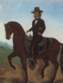
Much of Irvine was originally part of Rancho San Joaquín, granted in 1842 to José Andrés Sepúlveda, a famed Californio vaquero.
-
Camp Bonita at Irvine Ranch in 1937
-

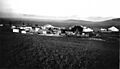
Suburban development in Irvine Ranch in 1975
-
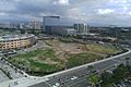
The developing urban core in the city of Irvine in 2010
-
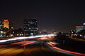
A view of the Irvine Business Complex and the 405 Freeway
-
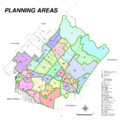
The planning areas of Irvine
-
Rue Rueda Gigante Square in Irvine Spectrum
-
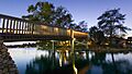
A bridge over the artificial North Lake in Woodbridge, an Atlantic-style neighborhood
-

University High School in Irvine
-
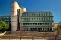
McGaugh Hall at the University of California, Irvine
-
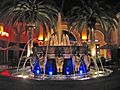
Fountain at Irvine Spectrum Center. The center and its surrounding areas constitute a significant part of Irvine's economy.
-
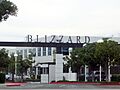
Blizzard Entertainment headquarters is located in Irvine.
-
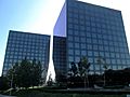
Among other companies, Toshiba America Electronics is located in the Newport Gateway buildings on MacArthur Boulevard.
-
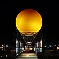
Orange County Great Park air balloon ride
-
The Irvine Transportation Center, also known as the Irvine Station
-
Intersection of Jamboree and Main showing a typical Irvine road


_01.JPG)

See also
 In Spanish: Irvine (California) para niños
