San Joaquin Hills facts for kids
Quick facts for kids San Joaquin Hills |
|
|---|---|

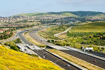
State Route 73 climbs into the San Joaquin Hills, as seen looking southward from University Hills, Irvine
|
|
| Highest point | |
| Peak | Temple Hill (California) |
| Elevation | 1,050 ft (320 m) |
| Geography | |
| Country | United States |
| State | California |
| Region | Peninsular Ranges |
| District | Orange County |
| Range coordinates | 33°36′42.081″N 117°48′33.198″W / 33.61168917°N 117.80922167°W |
| Borders on | Santa Ana Mountains |
| Topo map | USGS Laguna Beach |
The San Joaquin Hills are a group of small mountains in Orange County, California, right along the coast. They are part of a bigger system called the Peninsular Ranges.
These hills stretch from Newport Beach in the northwest, near the edge of the Los Angeles Basin, all the way southeast to San Juan Capistrano.
Contents
Exploring the San Joaquin Hills
The San Joaquin Hills have several named peaks. From north to south, these include:
- French Hill in Turtle Rock, Irvine.
- Signal Peak and Pelican Hill, both close to the Newport Coast area of Newport Beach.
- Temple Hill in Laguna Beach, which many people call "Top of the World."
- Niguel Hill in Laguna Niguel.
How the Hills Were Formed: Geology Facts
Deep below the San Joaquin Hills is a hidden break in the Earth's crust called the San Joaquin Hills blind thrust. Scientists believe that the hills were pushed up and formed by movement along this fault.
The main part of the San Joaquin Hills runs southeast from the Upper Newport Bay area. It reaches its highest point, about 1,000 feet (300 m), near Laguna Beach. Many high parts of the hills are between 600 to 800 feet (180 to 240 m) tall.
The hills are about 16 miles (26 km) long and can be up to 3 to 4 miles (4.8 to 6.4 km) wide. In many places, the San Joaquin Hills drop straight down into the Pacific Ocean, forming steep sea cliffs.
Waterways and Canyons of the Hills
Streams that start on the west side of the hills and flow towards the ocean include Buck Gully, Los Trancos Creek, Muddy Creek, El Moro Creek, Emerald Creek, Prima Deshecha Cañada, Segunda Deshecha Cañada, and Christianitos Canyon. On the east side, water drains into Bonita Creek, Sand Canyon Wash, San Joaquin Wash, and La Cañada Wash.
Many cities are located around the hills, such as Newport Beach, Irvine, Laguna Hills, Aliso Viejo, Laguna Beach, Laguna Niguel, Dana Point, San Juan Capistrano, and San Clemente.
During the last Ice Age, rivers cut through the San Joaquin Hills. This means the hills are not one continuous mountain range. For example, Newport Bay was formed when the Santa Ana River changed its path. Laguna Canyon was also carved by a creek, but that creek later moved, leaving a "wind gap" (a valley without a river).
The largest canyon is Aliso Canyon, cut by Aliso Creek. Further south, the hills become smaller ridges, cut by the canyon of Salt Creek. The very southern part of the hills is cut by San Juan Creek.
Plants and Animals: Local Ecosystems
The natural plants in the San Joaquin Hills are mostly coastal sage scrub and California chaparral and woodlands. You can also find grasslands, oak woodlands, wetlands, and riparian (riverbank) habitats along the streams.
Millions of years ago, this land was under the ocean. When the San Joaquin Hills Toll Road was being built, workers found over 40,000 fossils! Some of these fossils were 35 million years old, including 5-million-year-old fossilized whales.
History of the San Joaquin Hills
The hills get their name from Rancho San Joaquin. This ranch was owned by Jose Andres Sepulveda and was formed in 1842. It covered the northern part of the hills. Later, this ranch became part of the Irvine Ranch. Another Mexican ranch, Rancho Niguel, was located in the southeastern part of the hills.
Scientists think that the San Joaquin Hills blind thrust fault might have caused the first recorded earthquake in California. This big earthquake was felt in what is now northern Orange County on July 28, 1769, by Gaspar de Portolà.
See also
 In Spanish: Cerros de San Joaquín para niños
 | Kyle Baker |
 | Joseph Yoakum |
 | Laura Wheeler Waring |
 | Henry Ossawa Tanner |


