Salt Creek (Orange County) facts for kids
Quick facts for kids Salt Creek |
|
|---|---|

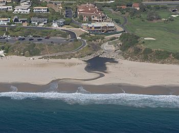
Mouth of Salt Creek at Dana Point
|
|
| Country | United States |
| State | California |
| Counties | Orange County |
| Cities | Laguna Niguel, Dana Point, San Juan Capistrano |
| Physical characteristics | |
| Main source | Orange County, California 33°31′23″N 117°41′25″W / 33.52306°N 117.69028°W |
| River mouth | Pacific Ocean Laguna Beach, California 0 ft (0 m) 33°28′53″N 117°43′31″W / 33.48139°N 117.72528°W |
| Length | 4 mi (6.4 km) |
| Basin features | |
| Basin size | 6.1 sq mi (16 km2) |
Salt Creek is a small stream located in southern Orange County, California. It flows for about 4 miles (6.4 km) and drains an area of 6.1 square miles (16 km2). This area includes parts of the cities of Laguna Niguel, Dana Point, and San Juan Capistrano.
Most of Salt Creek has been changed by people, meaning it flows through channels or underground pipes. It doesn't have any major streams that flow into it on the surface. The creek starts in Laguna Niguel and flows through a narrow area called the Salt Creek Corridor. This corridor is mostly a long, thin park. From there, it goes into the Monarch Beach Golf Course in Dana Point. Finally, it enters an underground storm channel that carries it to the Pacific Ocean at Salt Creek County Beach.
Contents
What's in a Name?
The name "Salt Creek" comes from Spanish explorers. They called the creek "Arroyo Salado", which means "Salt Creek" in Spanish. Sadly, the original name given to the creek by the native people who lived there long ago has been lost.
Where Does Salt Creek Flow?
Salt Creek begins in a series of small valleys in Laguna Niguel. These valleys are west of a main road called Street of the Golden Lantern. The area where the creek starts is protected as part of the Salt Creek Corridor Regional Park. This park covers most of the creek's path.
The creek winds west through a narrow valley. It collects water from homes and communities located both north and south of the Salt Creek Canyon. Before it goes under Niguel Road, it gets water from a large storm drain. This drain collects water from a big valley to the north.
Niguel Road crosses Salt Creek on a high dirt structure. The creek flows underneath in a concrete pipe called a culvert. Salt Creek then turns southwest and flows next to Niguel Road. It continues through a valley that isn't built up but has been changed to stop erosion. The Salt Creek Trail also starts here and follows the creek all the way to the ocean.
Near Camino del Avion, another road, the creek goes into another concrete pipe. It flows under the road to a small pond. Like Niguel Road, Camino del Avion crosses on a dirt structure. Only a small part allows the Salt Creek Trail and floodwaters to pass underneath.
A large stream that flows south used to join Salt Creek. This stream is now sent into pipes and is called the Arroyo Salada Storm Channel. Some people think that Sulphur Creek, which is a stream to the north, originally flowed into this channel. This would have made it a part of Salt Creek.
Salt Creek then flows through a golf course near the ocean. Several smaller valleys join the Salt Creek Canyon. After this, Salt Creek goes into a huge concrete pipe that takes it underground. This pipe follows the path of a valley that is now filled in. The pipe lets the water out onto a concrete area at Salt Creek Beach. Here, the water is treated before it goes into the sea.
Salt Creek's Watershed
The area that drains into Salt Creek, called its watershed, is about 6.1 square miles (16 km2). This makes it the smallest major watershed in Orange County. It looks a bit like the letter "Y". The two arms of the "Y" are Salt Creek itself and its main branch, the Arroyo Salada Storm Channel.
This watershed is mostly surrounded by the San Joaquin Hills. It is a hilly area east of the Aliso Creek watershed and south of the Sulphur Creek area. To the west, it borders the valleys of San Juan Creek and Trabuco Creek. The eastern part of the watershed is in San Juan Capistrano. The southern part is between Dana Point and Laguna Beach. About two-thirds of the watershed is within the city of Laguna Niguel.
About 1.2 million years ago, the San Joaquin Hills rose up. If this hadn't happened, the Salt Creek watershed might look very different. The stream that is now the Arroyo Salada Storm Channel was once part of Sulphur Creek. Sulphur Creek flows into Aliso Creek to the north. In the past, the Sulphur Creek-Arroyo Salada combination would have been the main part of Salt Creek. It would have flowed south to the Pacific and added over 4 square miles (10 km2) to the Salt Creek watershed. Now, a low area separates these two drainage basins.
How Building Affects the Creek
Because of all the building and changes to the land, the original source of Salt Creek is gone. It used to be a small marshy wetland, but now there's a community pool there. The creek's flow is now directed into a storm drain. This means the actual start of the creek has moved underground, under a street called Marina Hills.
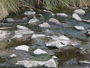
During dry times, almost all the water in Salt Creek comes from urban runoff. This is water that flows over streets and yards. You can tell this because the creek always has some water, even when it's dry. However, this water doesn't have much life in it. It's often full of stringy algae, which grows because of nitrates from yard fertilizer.
Because of these big changes, Salt Creek has no surface streams flowing into it. It's also not a good home for most animals, except for tiny mosquito fish and tadpoles. Sometimes, you can even see soap suds on the water's surface. These come from homes and businesses in the area.
A Look Back in Time
Long ago, the Salt Creek area was home to the Acjachemen Native American group. Later, Spanish missionaries called them the Juaneño. They founded Mission San Juan Capistrano farther south. It's possible that Juaneño villages were once located along the lower part of Salt Creek. This is because springs fed the creek, providing a small but steady flow of water all year.
By the 1960s, many homes had been built in the Salt Creek watershed. Mountains were flattened, and the dirt was used to fill small valleys. This created flat land for tract housing and roads. However, the Salt Creek Canyon itself remained mostly undeveloped. There was a golf course, the Monarch Beach Golf Links, at its southern end. Another golf course was built around the main part of the Arroyo Salada Storm Channel.
Even in the 1970s, the lowest part of the Salt Creek Canyon still existed. But this part of the canyon was also filled in with dirt. This was done to build more houses and the Pacific Coast Highway.
Keeping Salt Creek Clean
The Salt Creek watershed has a lot of buildings, which means it's heavily affected by polluted urban runoff. Before 2004, about 2.2 cubic feet per second (0.06 m3/s) of polluted water flowed directly into the ocean. This caused a harmful cloud of pollution to spread along the beach, often leading to beach closures.
In 2004, the Salt Creek Ozone Treatment Plant was built for $6.7 million USD. This facility cleans the runoff using ozonation. It removes toxins, bacteria, trash, polluted dirt, and other harmful substances. The plant makes the water safe for people to touch, though it's not safe to drink.
 | Calvin Brent |
 | Walter T. Bailey |
 | Martha Cassell Thompson |
 | Alberta Jeannette Cassell |


