Sulphur Creek (California) facts for kids
Quick facts for kids Sulphur Creek |
|
|---|---|
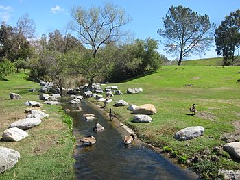
In Laguna Niguel Regional Park
|
|
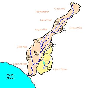
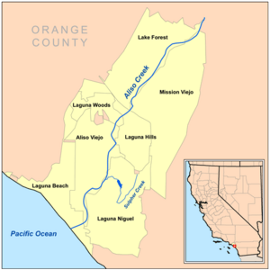
Map of Aliso Creek watershed with Sulphur Creek subwatershed highlighted
|
|
| Other name(s) | Cañada Salada, Arroyo Salada |
| Country | United States |
| State | California |
| Counties | Orange County |
| Cities | Laguna Hills, Laguna Niguel, San Juan Capistrano |
| Physical characteristics | |
| Main source | Convergence of several storm drain outlets, Laguna Hills 190 ft (58 m) 33°33′33″N 117°41′04″W / 33.55917°N 117.68444°W |
| River mouth | Aliso Creek just above the beginning of Aliso and Wood Canyons Regional Park and downstream of Laguna Niguel Regional Park Laguna Niguel 58 ft (18 m) 33°32′32″N 117°42′16″W / 33.54222°N 117.70444°W |
| Length | 4.8 mi (7.7 km) |
| Basin features | |
| Basin size | 6 sq mi (16 km2) |
| Tributaries |
|
Sulphur Creek is a small stream, about 4.5-mile (7.2 km) long, located in Orange County, California. It flows into Aliso Creek. This creek helps drain an area of about 6 square miles (16 km2), which includes homes and parks in the southern San Joaquin Hills.
Long ago, the area around Sulphur Creek was home to the Acjachemen Native Americans. Later, in the 1800s, it became a large farm or "rancho." Starting in the 1960s, more and more houses were built here. In 1966, the Sulphur Creek Dam was built, creating Laguna Niguel Lake.
Today, Sulphur Creek flows through cities like Laguna Niguel, Laguna Hills, and San Juan Capistrano. You can also find it in Laguna Niguel Regional Park and Aliso and Wood Canyons Regional Park. Because of water running off from city areas, the creek now flows all year round, even though it used to be a seasonal stream. Much of the creek has been changed to control floods, but some parts still have natural areas for plants and animals.
Contents
Where Does Sulphur Creek Flow?
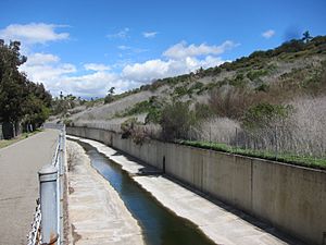
The creek starts from a storm drain near Crown Valley Parkway and Greenfield Drive. It flows southwest, following Crown Valley Parkway. The first part of the creek is a narrow area of restored wetlands. However, it goes through concrete tunnels under Moulton Parkway, Nueva Vista Drive, and La Paz Road. Below La Paz Road, the creek flows in a concrete channel about 4 feet (1.2 m) wide, but its sides are still natural.
The creek then turns sharply north at Crown Valley Park. Here, two smaller streams, the Niguel Storm Drain and another unnamed stream, join it. Sulphur Creek continues north through a narrow valley. It passes a water treatment plant in a large concrete channel. This channel turns back into a natural stream when it reaches Laguna Niguel Regional Park. The Sulphur Creek Dam creates Laguna Niguel Lake, which is about 1.5 miles (2.4 km) long and covers 44 acres (18 ha).
Water leaves the dam through a concrete spillway on the east side. It then flows through the middle of Laguna Niguel Regional Park. About half a mile (0.8 km) downstream from the dam, North Sulphur Creek (also called Narco Channel) joins it. North Sulphur Creek is mostly underground and brings a lot of pollution into Sulphur Creek and Aliso Creek.
Sulphur Creek then flows west, past Kite Hill, and goes under Alicia Parkway through a culvert. After this, it flows through a small canyon. Another unnamed stream joins it from the left before Sulphur Creek finally meets Aliso Creek at the edge of Aliso and Wood Canyons Wilderness Park.
How Did Sulphur Creek's Landscape Form?
Millions of years ago, much of this area was covered by a warm, shallow sea. Over time, the sea moved back, leaving a flat coastal plain. About 1.22 million years ago, the San Joaquin Hills began to rise up. These hills grew slowly, about 0.6 to 0.8 feet (0.18 to 0.24 m) every thousand years, reaching heights of 500 to 700 feet (150 to 210 m). The highest peaks are around 1,000 feet (300 m).
This rising land changed Sulphur Creek's path. It used to flow south to Salt Creek, but now it flows north to Aliso Creek.
The flat areas and valleys between the San Joaquin Hills and the taller Santa Ana Mountains were formed by river sediments. Sulphur Creek's area is in the southern San Joaquin Hills. Here, many smaller hills have formed instead of one long mountain chain. These hills are made of sedimentary rocks from the Miocene period. The oldest rocks are called the Vaqueros Formation, and the younger ones are the Monterey Formation.
Sulphur Creek's Water Area
The Sulphur Creek watershed covers about 6 square miles (16 km2). A watershed is the area of land where all the water drains into a specific creek or river. This watershed is mostly residential. It is next to the Aliso Hills Channel area to the north and the Salt Creek basin to the south.
Most of the Sulphur Creek basin is hilly. People have changed the land a lot to build homes. Many canyons that used to drain into the creek have been filled in. Storm channels and drains are often built where these canyons once were.
A Look Back: Sulphur Creek's History
The land around Sulphur Creek was historically part of the Acjachemen Native American territory. A village called Niguili was likely near where Aliso and Sulphur Creeks meet. The city of Laguna Niguel gets its name from this old settlement.
From 1842 to the 1960s, the entire area was known as Rancho Niguel. This was a large Mexican land grant. Over time, parts of the ranch were sold. In the 1960s, the City of Laguna Niguel bought a big part of the ranch. This land was later given to the county for parks and recreation. Today, the county manages the upper and lower parts of the creek, and the Orange County Flood Control District manages Laguna Niguel Lake.
In the 1950s, the U.S. Army Corps of Engineers built a large dam, about 485 feet (148 m) long and 42 feet (13 m) high, across Sulphur Creek. This created Laguna Niguel Lake, which flooded about 1.5 miles (2.4 km) of the creek's original path. The lake is stocked with fish.
By the 1960s, homes started to appear on the hills west of the creek. Water running off from these city areas began to flow into the creek, making it more polluted. In 1973, the 236-acre (0.96 km2) Laguna Niguel Regional Park was created. In 1990, the very end of the creek became part of Aliso and Wood Canyons Regional Park.
Environmental Concerns and Restoration Efforts
Historically, the Sulphur Creek area was mostly hilly with chaparral and coastal sage scrub plants. The creek banks likely had live oak, sycamore, alder, and other small trees. Most of this natural habitat was cleared for housing starting in the 1960s. However, some undeveloped areas remain, especially around Laguna Niguel Regional Park.
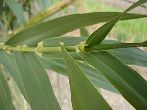
Some non-native plants have been introduced to the Sulphur Creek area. These include Arundo donax (giant reed), castor bean, and tobacco tree. Giant reed is a big problem because it grows very fast and takes over, pushing out native plants. This reduces the natural homes for local animals. It also uses a lot of water. During floods, pieces of giant reed can break off and start new plant colonies downstream.
While no raw sewage enters the creek, a lot of urban runoff flows into it. This is water from paved surfaces like roads and parking lots that picks up pollution before flowing into the creek without being treated. This untreated runoff has caused contamination by bacteria like E. coli and Enterovirus, making the water unsafe for people to touch. The County of Orange estimates that 87 percent of Sulphur Creek is "severely degraded." Too many nutrients from fertilizers and other pollutants in urban runoff have also caused algae blooms and eutrophication (too many nutrients) in the creek above Laguna Niguel Lake.
Good news! Several projects are happening in the Sulphur Creek watershed. These projects aim to remove the non-native plants and bring back the native plants that belong there.
The Aliso and Wood Canyons Regional Park, at the lower end of Sulphur Creek, has many more native plant and animal species than the Sulphur Creek watershed itself.
Fun Things to Do at Sulphur Creek
Laguna Niguel Lake is the main place for fun activities in the area. It's known as one of the best fishing spots in Southern Orange County. The lake is stocked every year with fish like bluegill, catfish, and bass.
Besides the lake, there are other parks in the watershed, such as Crown Valley Park and Sulphur Creek Park. There's also a paved trail that follows Sulphur Creek. You can walk or bike on this trail from near Crown Valley Park to where the creek crosses Alicia Parkway.
What's in a Name? The Meaning of "Sulphur Creek"
Sulphur Creek has other names too, like "Arroyo Salada" (which means "Salt Canyon" in Spanish) and "Cañada Salada" ("Valley of Salt" or "Salt Canyon"). These names, from Spanish times, suggest that the creek naturally had salty water.
Since Salt Creek to the south has a similar name, and a "Salt Canyon" storm channel is in the lower part of the old Sulphur Creek area, it seems these two creeks might have been connected long ago. The saltiness helps prove this idea.
 | Kyle Baker |
 | Joseph Yoakum |
 | Laura Wheeler Waring |
 | Henry Ossawa Tanner |


