
Aliso and Wood Canyons Wilderness Park facts for kids
Quick facts for kids Aliso and Wood Canyons Wilderness Park |
|
|---|---|

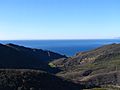
A view of Aliso Canyon and the Pacific Ocean, looking westward.
San Clemente and Santa Catalina islands are visible in the distance. |
|

Aliso and Wood Canyons Wilderness Park
Location in southern California
|
|
| Location | Orange County, California, United States |
| Nearest city | Aliso Viejo, Dana Point, Laguna Beach, Laguna Niguel |
| Area | 4,500 acres (18 km2) |
| Max. elevation | Temple Hill 33°33′18″N 117°45′29″W / 33.55500°N 117.75806°W 1,036 ft (316 m) |
| Min. elevation | Aliso Creek 14 ft (4.3 m) |
| Established | 1990 |
| Operator | OC Parks |
| Website | OC Parks |
Aliso and Wood Canyons Wilderness Park is a large park in Orange County, California. It covers about 4,500 acres (1,821 hectares) of wild land. This includes rugged canyons, open grassy areas, and forests near streams. The park is surrounded by cities like Aliso Viejo and Laguna Beach.
This park is part of a bigger area called the South Coast Wilderness. It is an important place for wildlife because it's surrounded by many homes and the Pacific Ocean. The park has trails for hiking, mountain biking, and horseback riding. You can also find interesting things like caves, natural springs, and old fossils.
The name Aliso comes from the 1700s. Spanish explorers likely named Aliso Creek after the white alder trees. These trees grow naturally in the area. Wood Canyon was probably named for its many California live oak and sycamore trees.
Contents
History of the Park
Early Inhabitants of Aliso Canyon
Long ago, the Acjachemen and Tongva Native American tribes lived here. Aliso Creek was a natural border between their lands. They usually lived together peacefully. Aliso Canyon was a key winter home for these groups. It had fresh water and easy access to the ocean. The Acjachemen village of Niguili was located in the park. It was near where Aliso Creek and Sulphur Creek meet.
Spanish and Mexican Eras
In 1769, the Spanish Portola expedition explored this area. Spanish ships also visited the bay at Aliso Canyon. They would collect large timbers from the river area. Later, the Spanish built missions to teach Christianity to Native Americans. The people from Aliso Canyon moved to the nearby Mission San Juan Capistrano.
After Mexico became independent in 1821, mission lands were divided. Most of what is now the park became part of Rancho Niguel. This large ranch was given to Juan Avila in 1842. California became part of the United States in 1850. After a big drought, Avila sold the ranch in 1865. The land changed owners many times. Finally, Lewis Moulton and Jean Pierre Daguerre bought it in 1895.

Outlaws and Early Settlers
In the 1800s, Aliso Canyon offered a hidden place for some people. Dripping Cave, a natural shelter, became a hideout. It was used by a group who robbed stagecoaches. These coaches traveled between Los Angeles and San Diego. Even after the group was caught, the cave kept its nickname, "Robbers Cave."
In 1871, Eugene Salter was the first white settler along Aliso Creek. He claimed 152 acres (62 hectares) in the canyon. The next year, the Thurston family took over. They used water from Aliso Creek to grow an orchard.
Saving the Canyon from Development
For the first half of the 1900s, Aliso Canyon was used for sheep ranching. But tourism also grew. Aliso Beach became popular. The Aliso Creek Inn and Golf Course opened in 1950. In the 1960s, the Rancho Niguel land was sold. It was planned for new cities like Aliso Viejo and Laguna Niguel. There was even a plan for a six-lane highway through the canyon.
But the canyon was saved from being built on. The county bought about 40 pieces of land for a park. The biggest donation was in 1979. The Mission Viejo Company gave 3,400 acres (1,376 hectares). The park officially opened on March 31, 1990. It was first called Aliso and Wood Canyons Regional Park. Later, it became a Wilderness Park to better protect its natural areas. More land has been added since then, making the park its current size.
What Makes the Park Special?

The park includes the amazing Aliso Canyon. This valley was carved by Aliso Creek. The creek flows through the San Joaquin Hills from the Cleveland National Forest to the Pacific Ocean. Wood Canyon is formed by Wood Canyon Creek. This creek flows south to meet Aliso Creek in the middle of the park. Another creek, Sulphur Creek, joins Aliso Creek at the park's east end.
The park's elevation ranges from 14 feet (4 meters) above sea level. It goes up to 1,036 feet (316 meters) at Temple Hill. Temple Hill is in Laguna Beach and is sometimes called "Top of the World." On a clear day, you can see most of Orange County from here.
Connecting Park Systems
Aliso and Wood Canyons connects two main park systems in Orange County. The South Coast Wilderness covers 22,000 acres (8,903 hectares). It protects much of the San Joaquin Hills. This includes Laguna Coast Wilderness Park, which is next to Aliso and Wood Canyons. The Aliso Creek Corridor is a green area. It stretches 19 miles (31 km) along Aliso Creek. It reaches national forest lands in the Santa Ana Mountains.
The park almost touches Aliso Beach County Park. But a private property, The Ranch at Laguna Beach, separates them. This means visitors cannot easily walk from the park trails to the beach.
Historical Discoveries
The park holds many items from people who lived here long ago. These include ancient shell piles and rock shelters. You can also find old stone tools. There are also historic farm tools and buildings from the Rancho Niguel period. Some of these sites are the Moulton Cement Plant and the Tischler Rock.
Park Climate
The park has a warm, dry Mediterranean climate. Winters are mild, and summers are hot. Most of the rain falls between December and March. The park gets about 16.42 inches (417 mm) of rain each year.
Trails and How to Visit
The park is open from 7 AM until sunset. The main entrance is off Alicia Parkway in Laguna Niguel. There is no entry fee, but parking costs $3.
There are about 30 miles (48 km) of trails in the park. The paved Aliso Creek Trail goes through the whole park. The unpaved Wood Canyon Trail ends at Canyon View Park in Aliso Viejo. The Aliso Creek Trail continues north as a paved path for walking and biking. Wood Canyon is popular for horseback riding. The hills around Wood Canyon have many mountain biking paths. These range from easy to hard. Dripping Cave is a popular spot for a beginner's hike. The Aliso Summit and West Ridge trails follow the high ridges of the park.
Geology of the Park
Aliso Canyon started forming about 1.2 million years ago. Aliso Creek carved its way through the hills as the land rose. During the Ice Age, about 10,000 years ago, Orange County was much wetter. Sea levels were lower. Much more water flowed through Aliso Creek then. This created the deep canyon we see today. After the Ice Age, sea levels rose. This filled the canyon with water, creating a shallow bay. Over time, sediment from Aliso Creek filled the canyon. This created the flat valley floor. Today, the creek seems too small to have carved such a large canyon.
The San Joaquin Hills are made of sedimentary rock from the ocean floor. This rock was pushed up above sea level. As the creek cut through the hills, it revealed layers of rock. These layers date back millions of years. Limestone in the park has thousands of fossils. These include ancient dolphins, whales, and sea creatures. These fossils help scientists understand how life and climates changed millions of years ago.
Park Ecology: Plants and Animals
The park's plants and animals live in three main types of natural areas. These are coastal sage scrub, chaparral, and grassland. Chaparral often grows with sage scrub on the park's hills. Grasslands cover the valley floor. Areas along the streams are called riparian zones. The park is a special place for wildlife. It protects 137 types of birds that live or migrate here.
Plants of the Park

The bottom of Aliso Canyon has seasonal grasslands. These grow well in spring and fade by late summer. The park protects many special plant species. These include many-stemmed dudleya and Orange County Turkish rugging. You can also find hummingbird sage and crown-beard. Oak and sycamore trees grow in Wood Canyon. Marshes and wetlands are found along Aliso Creek. The native grasslands in the park's less visited areas are still very healthy.
Animals of the Park

The park is one of the largest safe places for mammals in coastal Orange County. These include coyotes and bobcats. Many special birds, small mammals, and reptiles find shelter here. Some of these are the California gnatcatcher, pond turtle, and San Diego horned lizard. You might also see great egrets, white-tailed kites, and different types of hawks. Up to five bald eagles have been seen in Aliso Canyon. Peregrine falcons have also been spotted flying along the canyon walls.
Fish in Aliso Creek
Aliso Creek used to be a major home for steelhead fish. But dams, pollution, and invasive plants have hurt the steelhead population. There are only rare sightings now. Near the creek's mouth, there was a large population of tidewater goby. These fish are unique to California. But they have mostly disappeared due to human development. Large Carp can still be found in the creek. They are one of the few fish that do well in the creek's warm, silty water.
Environmental Challenges
One big problem in Aliso and Wood Canyons is invasive species. These are plants and animals that are not native to the area. Many were brought in from old ranching activities or gardens. Plants like giant reed and pampas grass take over from native plants. They also offer less food for the animals. Giant reed has especially taken over areas along Aliso Creek. This reduces the variety of life there.
There are also invasive animals, like the Brown-headed cowbird. This bird lays its eggs in other birds' nests. Recent projects have used special methods to reduce these invasive species.
Protecting the Trails
Another challenge comes from hikers and mountain bikers. Sometimes, they create new trails as shortcuts. This can damage the natural habitat and slopes. Even before the park opened, motorcycles would often go into the park. This caused damage. Because of this, motorized vehicles are not allowed in the park, except for park workers. Rangers regularly block and replant unofficial trails. Visitors are asked to stay on marked trails to help prevent damage.
Erosion Issues
The Aliso Wastewater Management Agency (AWMA) was created in 1974. Its job was to clean wastewater for irrigation. A water treatment plant was built inside the future park. It would release extra water into Aliso Creek. But the population of south Orange County grew very fast. This increased the amount of wastewater going into Aliso Creek. This has caused problems with erosion inside the park.
In the 1990s, a dam was built on Aliso Creek inside the park. It was meant to control erosion and help restore the natural habitat. About 10,000 trees were planted. But after floods in 1997-98, the dam was badly damaged. This led to serious damage to the creek bed. Now, the creek flows in a deep ditch, 10 to 20 feet (3 to 6 meters) below the land. This has caused more environmental problems. It has also dried up former wetlands along the creek.
There have been ideas to control erosion along the creek. These would help restore habitat and protect pipelines. But they would also greatly impact the existing habitat. In 2008, the U.S. Army Corps of Engineers suggested a plan. It would build structures and underground walls to stop the creek from moving. This would involve moving a lot of earth and affecting 70 acres (28 hectares) of the park. In 2009, a study suggested letting the creek find its own balance. It said that more human changes might cause more problems. Because of environmental concerns, no such big project has been done yet.
Images for kids
-
A view of Aliso Canyon and the Pacific Ocean, looking westward.
-
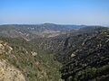
Aliso Canyon from near the summit of Niguel Hill, looking northward towards Temple Hill
-
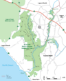
Trail map (click to enlarge)
-
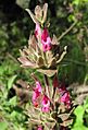
Hummingbird sage is native to southern California and flourishes in the park.
-
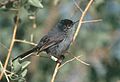
The California gnatcatcher inhabits undergrowth throughout the park.
-
Sign in Aliso and Wood Canyons Park

