
Monterey Formation facts for kids
Quick facts for kids Monterey FormationStratigraphic range: Miocene |
|
|---|---|

Outcrop of Monterey Formation, Gaviota State Park, California
|
|
| Type | sedimentary |
| Overlies | Rincon Formation |
| Location | |
| Region | California |
| Country | United States |
| Type section | |
| Named for | Monterey, California |
The Monterey Formation is a huge layer of rock found in California. It formed during the Miocene epoch, millions of years ago. This rock is very important because it contains a lot of oil. You can see parts of it sticking out of the ground (these are called outcrops) in different areas of California, including its coastal mountains and islands. It's named after the city of Monterey, California, where it was first studied.
This rock layer is the main source for most of California's known oil. Geologists have studied and mapped the Monterey Formation a lot to understand where oil might be found. Its rocks are mostly rich in silica, and their makeup and history can vary a lot.
In 2014, experts estimated that the Monterey Formation might hold about 600 million barrels of oil that could be taken out using special methods. However, this number has changed over time, and it's still uncertain how much oil can actually be produced from it. Even with a lot of effort from oil companies, it has been hard to get oil from the Monterey Formation, unless the rock is already naturally broken up.
The rocks in the Monterey Formation are not all the same. Older parts show signs of ocean water rising from below, bringing nutrients. This led to fossils and rocks made from tiny sea creatures like diatoms. Newer parts of the formation have even more of these tiny creatures. They formed unique rocks like diatomite (which is used in many products) and chert.
Contents
Oil in the Monterey Formation
The Monterey Formation has long been known as the main source of oil found in other rock layers in Southern California. The Monterey itself has produced a lot of oil where its rocks are naturally broken or cracked. Since 2011, there has been a lot of talk about whether a method called hydraulic fracturing (or "fracking") could help get oil from the Monterey Shale over large areas.
In 2011, the US Energy Information Administration (EIA) said that the Monterey Shale Formation, which covers about 1,750 square miles, held more than half of the United States' total estimated tight oil (oil trapped in shale rock). They thought it might contain about 15.4 billion barrels of oil that could be recovered. By 2012, this estimate was lowered to 13.7 billion barrels.
As of 2013, new ways of fracking and high oil prices made oil companies very interested in getting rights to drill in the Monterey Formation. The oil is found deep underground, between 6,000 and 15,000 feet below the surface.
A study in 2013 suggested that if fracking in the Monterey Formation was very successful, it could create many jobs and a lot of tax money for California. However, others pointed out that it has been hard to make fracking in the Monterey Shale profitable, except in places where the rock is already naturally fractured.
Experts like Richard Behl, a geology professor, explained that the Monterey Formation is much thicker and wider than other shale oil areas. But it is also much more complex and twisted geologically. This makes it harder to get the oil out.
Where the Oil Comes From
The Monterey Formation is believed to be the source of 84% of the oil in known oil fields in the San Joaquin Basin. This adds up to 12.2 billion barrels of oil. About 112 million barrels of oil from known fields are actually produced directly from the Monterey Formation itself.
The Monterey Formation is the source for huge oil fields like Kern River, Elk Hills, and Midway-Sunset Oil Field. It is also likely the source for the nearby North and South Belridge Oil Fields.
History of Oil Discovery
Oil from the Monterey Formation was first found at the Orcutt Oil Field in Santa Barbara County in 1901. Soon after, more oil was discovered in the Monterey Formation nearby, including at the Cat Canyon Oil Field and Lompoc Oil Field. These early discoveries relied on the natural cracks in the Monterey rock.
The Monterey Formation is also one of the rock layers that holds oil in the Elk Hills Oil Field in Kern County. Large amounts of Monterey oil were also found in offshore oil fields, such as the South Ellwood Oil Field and the Point Arguello Field.
New oil fields that produce mainly from the Monterey Formation were found in Kern County in 1983. However, getting the oil out of these fields has not been very profitable. Some companies have tried new drilling methods, but it's still a challenge.
Oil companies are also trying different methods to get more oil out. Some use acidizing, which involves injecting acids into the rock to help oil flow. Others are experimenting with different mixes of acids. Some believe that acidizing might be enough to open up the rock in the Monterey Shale, without needing fracking.
Environmental Concerns
The Monterey Formation lies under the southern part of the San Joaquin Valley, which is a very important farming area. Because of this, some farmers are worried about possible environmental damage from oil drilling and fracking. They want strict rules for these activities.
People also worry that fracking could be risky in California, which has many earthquakes.
In September 2013, the California legislature passed a law to regulate fracking. This law required oil companies to share what chemicals they use, test nearby water wells, and study environmental and safety issues. Some environmental groups felt the law was not strict enough, while oil companies thought it was too strict.
In Santa Barbara County, an energy company proposed drilling 136 wells in the Monterey Formation. They planned to use a method called cyclic steam injection to get the oil. In 2013, the local planning group asked for more studies because of concerns about greenhouse gas emissions. However, the project was later approved in November 2013.
Images for kids
-
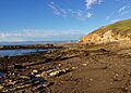
Upper Miocene Migeulito member exposed at Hazard Reef, Montana de Oro State Park. This is the first onshore outcrop of the Monterey Formation south of the Monterey Peninsula. Large exposures continue south along the coast, often associated with important oilfields.
-
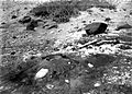
Tar "volcano" in the old Carpinteria Asphalt mine. Heavy oil exudes from joint cracks in the upturned Monterey shale forming the floor of mine. 1906 photo, U.S. Geological Survey Bulletin 321
-
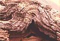
Fold in Monterey Formation
-
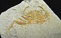
Fossil crab (Pinnixa galliheri), Monterey Formation, Pacific Grove, California. Carapace is about 3 cm. wide.
-
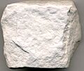
Diatomite (diatomaceous earth), Monterey Formation, from a diatomite quarry just south of Lompoc
-
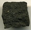
Heavy oil saturated sandstone from a unit of the Monterey Formation.


_Monterey_Formation_at_a_diatomite_quarry_just_south_of_Lompoc.jpg)

