Aliso Canyon facts for kids
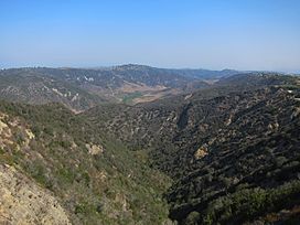
Aliso Canyon is a long valley, about 6.5-mile (10.5 km) (10.5 km) long, located in Orange County, California, in the United States. This canyon was carved by Aliso Creek through the San Joaquin Hills. It might have formed during the last Ice Age.
The canyon is in a semi-arid (dry) area. It is home to many different plants and animals. These include chaparral and coastal sage scrub plants. Some of the animals living here are even endangered.
Long ago, the northern part of the canyon was a border between two Native American tribes, the Acjachemen and the Tongva. Many old sites from the Acjachemen people have been found here. The rich soil and grasslands of Aliso Canyon were used for farming and grazing animals from the time of Spanish rule until the early 1900s. Since the 1970s, the canyon has been a main part of Aliso and Wood Canyons Wilderness Park.
However, Aliso Canyon has also faced environmental problems. As cities grew upstream, more urban runoff (rainwater from developed areas) flowed into Aliso Creek. This has caused a lot of erosion (wearing away of soil) in the valley. Pollution has also harmed the areas along the creek. There are plans to fix these issues, often by building special structures to control the erosion.
Contents
About Aliso Canyon
Geography of the Canyon
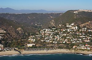
Aliso Canyon is a large opening through the middle of the San Joaquin Hills. These hills are a small coastal mountain range in Orange County. They are about 20 miles (32 km) (32 km) long and 5 miles (8.0 km) (8 km) wide. Aliso Canyon stretches about 6.5 miles (10.5 km) (10.5 km) from near Laguna Niguel Regional Park to the ocean at Laguna Beach.
The canyon is usually about 800 feet (240 m) (240 m) deep. At its widest, it is about 1.5 miles (2.4 km) (2.4 km) across. This makes it one of the biggest gaps through the San Joaquin Hills. Other large canyons nearby include Laguna Canyon and San Juan Creek canyon.
The valley has three main parts:
- The first part, upstream, is wide and not very deep. It is about 400 feet (120 m) (120 m) deep and 1.3 miles (2.1 km) (2.1 km) wide.
- The second part is the longest. It is about 1.5 miles (2.4 km) (2.4 km) wide and 800 to 900 feet (240 to 270 m) (240 to 270 m) deep. This section stretches about 4.5 miles (7.2 km) (7.2 km).
- The last part, closer to the ocean, is a narrow and steep gorge. It is about 0.8 miles (1.3 km) (1.3 km) wide and 700 feet (210 m) (210 m) deep.
Most of the valley floor is filled with deep alluvium (silt, sand, and gravel deposited by flowing water). This layer can be up to 300 feet (91 m) (90 m) thick. From the valley floor, the hills rise sharply to the canyon rim. Many short, steep side canyons cut into these hills.
Wood Canyon Creek flows through Wood Canyon, which is a major branch of Aliso Canyon. Wood Canyon is about 2.8-mile (4.5 km) (4.5 km) long and 600-to-800-foot (180 to 240 m) (180 to 240 m) deep. It joins Aliso Canyon about 5 miles (8.0 km) (8 km) upstream from the ocean. The cities around the canyon are Laguna Beach, Laguna Niguel, and Aliso Viejo.
How the Canyon Formed
Even though Aliso Canyon is large, it probably formed quite recently. This happened during the Wisconsinian glaciation, which was a cold period from about 60,000 to 10,000 years ago. During this time, the San Joaquin Hills began to rise.
The Wisconsinian glaciation changed the weather across North America. It brought cold, rainy weather to California. The sea level was also much lower than it is today. This new rainy climate meant Southern California got a lot of rain each year. This made the rivers and streams very powerful, causing them to erode (wear away) the land strongly.
Aliso Creek carved a V-shaped river valley through the San Joaquin Hills during this period. By the end of this cold era, the canyon was already very deep. When the glaciers melted, sea levels rose to their current height. Water then flowed into Aliso Canyon and Wood Canyons, turning them into saltwater inlets. Over time, the creeks filled these inlets with sediment, creating the flat valley floor we see today. This is why the canyon looks like a U-shaped glacial valley, even though it was carved by a river.
Changes Made by People
In the past, the floor of Aliso Canyon had a wide Aliso Creek that often changed its path. Even though the creek through the canyon is not fully controlled by walls, it has been affected by more water runoff and pollution. As cities grew upstream, more water with less natural dirt flowed into the creek. This has caused the creek to dig a deeper channel, about 20-foot (6.1 m) (6 m) deep and 50-to-100-foot (15 to 30 m) (15 to 30 m) wide, along the whole valley. The creek is still digging deeper into the soft soil. Also, a non-native plant called giant reed has grown widely throughout the valley.
There are two roads in Aliso Canyon, one on each side of the creek. One is the paved Aliso Creek trail. The other is a private, unpaved road that goes to a wastewater treatment plant near the canyon's mouth. There is also one dam and one small wall (weir) across the creek. A sewer line also runs along most of the canyon.
Most of Aliso Canyon is still undeveloped. However, there is some private development near the mouth of the canyon. This includes a hotel and a golf course. This part of the canyon, which is the steepest and narrowest, can flood during very rainy years.
Wildlife and Plants
Aliso Canyon has four main types of plant areas: riparian (along the creek), chaparral, coastal sage scrub, and grassland. In the past, there were salt marshes at the mouth of Aliso Creek. These marshes were home to many tidewater goby fish. However, these marshes are now gone because a sewage treatment plant was built there.
Oak and sycamore trees are the main large plants along Wood Canyon Creek. Alder trees (which gave the canyon its name), live oak, and other plants grow along Aliso Creek. Most of the rest of the valley floor is grassland. The side canyons and slopes have chaparral and coastal sage scrub plants. Some plants that are not native to the area have started to grow from nearby neighborhoods.
Large mammals like Bobcats, mountain lions, lynx, and coyotes live in the Aliso Canyon area. More than 100 types of birds also live here. Some, like the California gnatcatcher and sometimes the bald eagle, are endangered. Carp are the only fish left in the lower Aliso Creek. It is known that the endangered Southern steelhead trout used to live and spawn (lay eggs) in the creek until the early 1970s. Bald eagles and Native American tribes used to eat these trout.
History of the Canyon
It is believed that Aliso Creek was once the border between the Acjachemen and Tongva tribes. However, Aliso Canyon itself was likely fully on Acjachemen land. The mountains to the north and west of the canyon are steeper and higher than those to the south and east. The northern edge of the canyon marked the tribal boundary here. The Acjachemen people lived in small villages all along the valley floor. Aliso Creek flowed all year round, fed by springs. It supported a rich riparian ecosystem with many tall trees and smaller plants.
When the Spanish built missions nearby in the 1770s, they made most Native Americans live at the missions. Aliso Canyon was then left empty for many years. In 1842, Juan Avila became the owner of the canyon. It was part of his Rancho Niguel, which covered about 13,500 acres (55 km2) (55 km²) of the canyon area. The rich soil and large grasslands of the canyon floor were mainly used for grazing cattle. Some old cattle pens (corral) can still be seen in the Wood Canyon area today.
In 1871, a pioneer named Eugene Salter settled at the canyon mouth. A year later, he sold it to the Thurstons, who grew fruit trees in the area where the golf course is now. When the city of Laguna Beach was founded in 1926, the area at the mouth of Aliso Canyon became a popular place for camping. The inn and golf course started in the 1960s and grew over the years. A plan to make the golf course bigger was eventually stopped.
In the 1960s, Orange County started to become very urbanized (more cities and buildings). To protect the canyon from more development, Aliso and Wood Canyons Regional Park was created in 1979. It grew to its current size by 1990.
Later, a project called the Aliso Creek Wildlife Habitat Enhancement Project (ACWHEP) tried to restore the natural areas along the creek. It involved building a dam and pipes to water new plants. It also aimed to stop erosion from urban runoff. However, there was a problem with the design. The dam actually caused more erosion, and the irrigation pipes are now broken.
Old Discoveries
Marine Fossils
The Pecten Reef, located in the northeast part of the canyon, is a place where you can see rocks from the Miocene period. This period was millions of years ago. Thousands of fossils of sea animals, fish, reptiles, and coastal birds have been found here. This tells us that this area was once under the ocean.
Scientists have also found well-preserved invertebrates (animals without backbones), tiny plankton, small sea creatures called bryozoa, and rare red, blue, and brown algae. Much of what we know about how life evolved, what ancient environments were like, and what the climate was like during the Miocene period in Orange County comes from the fossils found at Pecten Reef.
Signs of Human Life
About 70 old sites where humans once lived have been found along the canyon. These sites give us clues about the people who lived there long ago.
 | Calvin Brent |
 | Walter T. Bailey |
 | Martha Cassell Thompson |
 | Alberta Jeannette Cassell |


