
Wood Canyon Creek facts for kids
Quick facts for kids Wood Canyon Creek |
|
|---|---|

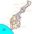
Map of the Aliso Creek watershed with Wood Canyon Creek subwatershed highlighted
|
|
| Country | United States |
| Physical characteristics | |
| Main source | Wood Canyon Emergent Wetland 600 ft (180 m) |
| River mouth | Aliso Creek 0 ft (0 m) 33°32′28″N 117°44′14″W / 33.54117228483748°N 117.73727830022864°W |
| Length | 2.8 mi (4.5 km) |
Wood Canyon Creek is a small river, about 2.8 mi (4.5 km) long. It flows all year round through the beautiful Aliso and Wood Canyons Wilderness Park in Orange County, California. This creek is like a smaller branch that feeds into a bigger river called Aliso Creek. It flows through a quiet, natural valley near the city of Aliso Viejo.
Long ago, the Acjachemen tribe lived in the Wood Canyon area. We know this because many old sites along the creek show where they used to live. Later, in the 1700s, Spanish explorers and settlers came. They built missions and large ranches, including one that covered the area around Aliso Creek.
Wood Canyon was first used for grazing cattle. After California became part of the United States, people used it to graze sheep. Since the 1960s, the creek's flow has been greatly changed by urban runoff. This is water from cities and towns that flows into the creek.
The Wood Canyon area is part of the San Joaquin Hills. These are coastal mountains that started to form about 1.22 million years ago.
Contents
Where Does Wood Canyon Creek Flow?
Wood Canyon Creek is about 2.8-mile (4.5 km) long. Today, it starts a little south of California State Route 73. The original start of the creek was filled in and now flows through pipes under neighborhoods.
Starting Point and Early Journey
The creek itself begins at a storm drain in Canyon View Park in Aliso Viejo. From there, it flows into a special artificial wetland. This wetland helps control and clean the water that runs off from the city. For its first 0.8 miles (1.3 km), the creek flows south. It moves through a narrow valley with many trees.
Widening Valley and Historic Sites
Further downstream, the valley gets wider. Here, you can find open grasslands and meadows. You might even see the remains of old sheep corrals built in the 1800s.
Joining Other Waters and Protecting the Trail
About halfway along its path, the creek gets water from the Muirlands Storm Drain. Then, another creek, Mathis Canyon Creek, joins it from the right. Mathis Canyon Creek only flows sometimes.
The creek flows past Temple Hill, a 1,000-foot (300 m) peak in the San Joaquin Hills. It crosses the Wood Canyon Trail three times. Several special structures called drop structures have been built here. These are made of rock and cement and help protect the trail from strong stormwater. Finally, the creek goes under the Aliso Creek Trail through pipes called culverts. It then flows down into Aliso Creek.
What is the Wood Canyon Creek Area Like?
The Wood Canyon area is entirely within the San Joaquin Hills. These are a small mountain range along the Pacific Coast of Orange County.
Size and Location of the Valley
It is a long, narrow valley, about 3 miles (4.8 km) long and 1.2 miles (1.9 km) wide. It is surrounded by dry slopes that are 700 to 1,000 feet (210 to 300 m) high. The whole area covers about 4 square miles (10 km2). Almost 80% of the Wood Canyon area forms the northern part of Aliso Canyon. Wood Canyon Creek is the second largest creek that flows into Aliso Creek, after Sulphur Creek.
Neighboring Areas and Development
Wood Canyon Creek flows almost parallel to Laguna Canyon to the west. The city of Aliso Viejo is to the east and north. Most of the Wood Canyon area is still natural and undeveloped. The Wood Canyon Trail follows the creek for its entire length. This trail is mostly a wide dirt road, but some parts are paved. The Dairy Fork area, another part of the Aliso Creek watershed, is next to Wood Canyon Creek to the northeast.
Human Impact and Nature
People have changed Wood Canyon Creek a lot. They have added things to control water runoff and erosion. Because of this, the Orange County Watershed and Coastal Resources Division calls it the Wood Canyon Channel. Some parts of the creek have banks lined with riprap, which are rocks used to prevent erosion. There are also three grouted riprap drop structures, each 3 to 5 feet (0.91 to 1.52 m) tall.
The area along the creek, called the riparian zone, is very important for plants and animals. It is one of the most noticeable natural areas in the entire Aliso Creek watershed. However, urban runoff has made this natural area less healthy.
Images for kids
-
Map of the Aliso Creek watershed with Wood Canyon Creek subwatershed highlighted
