
Tustin, California facts for kids
Quick facts for kids
Tustin, California
|
|||
|---|---|---|---|
.png)   Clockwise from top: Tustin High School Student Quad, Old MCAS Base Tustin Blimp Hangar, Sherman Stevens House
|
|||
|
|||
| Nickname(s):
City of Trees
|
|||

Location of Orange County, California (left), and of Tustin in Orange County (right)
|
|||

Tustin, California
Location in the United States
|
|||
| Country | United States | ||
| State | California | ||
| County | Orange | ||
| Incorporated | September 21, 1927 | ||
| Named for | Columbus Tustin | ||
| Government | |||
| • Type | Mayor-Council | ||
| Area | |||
| • Total | 11.12 sq mi (28.81 km2) | ||
| • Land | 11.12 sq mi (28.81 km2) | ||
| • Water | 0.00 sq mi (0.00 km2) 0% | ||
| Elevation | 138 ft (42 m) | ||
| Population
(2020)
|
|||
| • Total | 80,276 | ||
| • Density | 7,219.06/sq mi (18,697.28/km2) | ||
| Time zone | UTC−8 (Pacific) | ||
| • Summer (DST) | UTC−7 (PDT) | ||
| ZIP Codes |
92780–92782
|
||
| Area code(s) | 657/714, 949 | ||
| FIPS code | 06-80854 | ||
| GNIS feature IDs | 1661590, 2412117 | ||


Tustin is a city in Orange County, California, USA. It's part of the larger Los Angeles metropolitan area. In 2020, about 80,276 people lived there. The city of Tustin does not include the nearby area called North Tustin, which is a separate community.
Contents
History of Tustin


The first permanent European settlement in this area was Mission San Juan Capistrano, built on November 1, 1776. This was part of New Spain, which later became Mexico.
In 1801, the Spanish Empire gave a huge piece of land, about 62,500 acres (253 km2), to José Antonio Yorba. He called it Rancho San Antonio. This large ranch included the land where many cities like Orange, Santa Ana, and Tustin are today.
After the Mexican–American War, this area became part of the United States. American settlers started to arrive. In 1868, Columbus Tustin, a carriage maker, founded the city on 1,300 acres (5.3 km2) of land. The city officially became a city in 1927, with about 900 people living there.
Tustin in the 20th Century
During World War II, the U.S. Navy built a base for anti-submarine airships near Tustin. This base later became a Marine Corps helicopter station. Two huge wooden hangars were built there. They are among the largest wooden structures ever made and are considered important historical landmarks. Sadly, the north hangar burned down in 2023.
After the war, Tustin grew a lot. More people moved in, and the city expanded. Farmland and orchards were turned into homes and shopping centers.
-
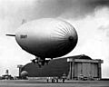
A U.S. Navy blimp in front of one of Tustin's huge blimp hangars in 1943
-
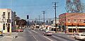
D and Main streets in the 1950s
-
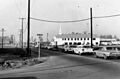
The intersection of Red Hill and San Juan in 1965


Geography and Climate
Tustin covers about 11.1 square miles (28.7 km2). It is next to Irvine to the south and east, Orange and North Tustin to the north, and Santa Ana to the west.
Tustin is sometimes called "The City of Trees." Many Sycamore and oak trees grew here naturally. The city's founder, Columbus Tustin, planted even more trees along the streets.
Neighborhoods in Tustin
Tustin has several distinct neighborhoods, including:
- Aliso
- Columbus Grove
- Columbus Square
- Greenwood
- Old Town Tustin
- Tustin Legacy
- Tustin Meadows/Peppertree/Laurelwood (one of the city's oldest planned areas)
- Tustin Ranch
Tustin's Weather
Tustin has a Mediterranean climate. This means it has warm, dry summers and mild, wet winters.
| Climate data for Tustin | |||||||||||||
|---|---|---|---|---|---|---|---|---|---|---|---|---|---|
| Month | Jan | Feb | Mar | Apr | May | Jun | Jul | Aug | Sep | Oct | Nov | Dec | Year |
| Mean daily maximum °F (°C) | 70 (21) |
71 (22) |
72 (22) |
75 (24) |
77 (25) |
80 (27) |
85 (29) |
87 (31) |
85 (29) |
80 (27) |
76 (24) |
70 (21) |
78 (26) |
| Mean daily minimum °F (°C) | 47 (8) |
48 (9) |
50 (10) |
53 (12) |
58 (14) |
61 (16) |
65 (18) |
67 (19) |
63 (17) |
57 (14) |
50 (10) |
46 (8) |
56 (13) |
| Average precipitation inches (mm) | 2.96 (75) |
3.07 (78) |
2.79 (71) |
.77 (20) |
.28 (7.1) |
.10 (2.5) |
.01 (0.25) |
.14 (3.6) |
.34 (8.6) |
.40 (10) |
1.22 (31) |
1.79 (45) |
13.87 (352) |
| Source: NOAA | |||||||||||||
People of Tustin
| Historical population | |||
|---|---|---|---|
| Census | Pop. | %± | |
| 1880 | 227 | — | |
| 1930 | 926 | — | |
| 1940 | 953 | 2.9% | |
| 1950 | 1,143 | 19.9% | |
| 1960 | 2,006 | 75.5% | |
| 1970 | 22,190 | 1,006.2% | |
| 1980 | 32,248 | 45.3% | |
| 1990 | 50,689 | 57.2% | |
| 2000 | 67,504 | 33.2% | |
| 2010 | 75,540 | 11.9% | |
| 2020 | 80,276 | 6.3% | |
| U.S. Decennial Census 1860–1870 1880-1890 1900 1910 1920 1930 1940 1950 1960 1970 1980 1990 2000 2010 2020 |
|||
In 2020, Tustin had a population of 80,276 people. The city is very diverse, with people from many different backgrounds.
Population Details (2020)
| Race / Ethnicity (NH = Non-Hispanic) | Pop 2000 | Pop 2010 | Pop 2020 | % 2000 | % 2010 | % 2020 |
|---|---|---|---|---|---|---|
| White alone (NH) | 30,264 | 26,317 | 22,901 | 44.83% | 34.84% | 28.53% |
| Black or African American alone (NH) | 1,785 | 1,535 | 1,619 | 2.64% | 2.03% | 2.02% |
| Native American or Alaska Native alone (NH) | 199 | 142 | 95 | 0.29% | 0.19% | 0.12% |
| Asian alone (NH) | 10,008 | 15,147 | 19,043 | 14.83% | 20.05% | 23.72% |
| Pacific Islander alone (NH) | 186 | 244 | 193 | 0.28% | 0.32% | 0.24% |
| Other race alone (NH) | 145 | 185 | 418 | 0.21% | 0.24% | 0.52% |
| Mixed race or Multiracial (NH) | 1,807 | 1,946 | 3,295 | 2.68% | 2.58% | 4.10% |
| Hispanic or Latino (any race) | 23,100 | 30,024 | 32,712 | 34.24% | 39.75% | 40.75% |
| Total | 67,504 | 75,540 | 80,276 | 100.00% | 100.00% | 100.00% |
Economy and Jobs
Tustin has many businesses that provide jobs for its residents. Here are some of the top employers in the city:
| # | Employer | # of Employees |
|---|---|---|
| 1 | Tustin Unified School District | 2,850 |
| 2 | SchoolsFirst Federal Credit Union | 983 |
| 3 | Young's Market Company LLC | 681 |
| 4 | Costco | 658 |
| 5 | New American Funding | 645 |
| 6 | City of Tustin | 409 |
| 7 | Avid Bioservices, Inc. | 230 |
| 8 | Vita Best Nutrition | 215 |
| 9 | Kaiser Permanente/Kaiser Foundation Hospitals | 200 |
| 10 | Logomark Inc. | 196 |
Fun Things to Do

Tustin offers several places for shopping, entertainment, and recreation.
Places to Visit
- The Market Place: A large outdoor shopping center.
- The District: Another popular shopping and entertainment area.
- Tustin Area Museum: Learn about the city's history.
- Enderle Center: A unique shopping village.
- Marconi Automotive Museum: See a collection of cool cars.
- Old Town Tustin: Explore historic buildings and shops.
- Tustin Ranch Golf Course: A place for golf enthusiasts.
Education in Tustin
Schools in Tustin are managed by the Tustin Unified School District. There are several highly-rated high schools in the area:
- Tustin High School: Known as a California Distinguished School. It also has a strong Model United Nations program.
- Foothill High School: Also a California Distinguished School.
- Arnold O. Beckman High School: Recognized as one of the "Best High Schools" by U.S. News & World Report.
Springfield College, a private college, is also located in Tustin.
City Services
Police and Fire Protection

The Tustin Police Department keeps the city safe. It was started in 1928 with just one officer, John Stanton. He was first called "street superintendent" but became "chief of police" two months later. For many years, he was the only officer, taking calls from his home. By 1948, the department had about three officers.
Fire protection services in Tustin are provided by the Orange County Fire Authority.
Famous People from Tustin
Many notable people have lived in Tustin, including actors and athletes.
Actors
- Cuba Gooding Jr., actor
- Rachel Kimsey, actress
- Matthew Lillard, actor
- Caroline Sunshine, actress
Athletes
- Sam Baker, former NFL player
- James Beaumont "Beau" Bell, NFL player
- Heath Bell, MLB player
- Milorad Čavić, swimmer
- Chris Chester, NFL player
- Gerrit Cole, MLB player
- DeShaun Foster, NFL player
- Evelyn Furtsch, swimmer
- Alfonso Gómez, boxer
- Doug Gottlieb, TV sports analyst and host, former college basketball player
- Mark Grace, former MLB player, coach
- Shawn Green, former MLB player
- Rex Hudler, former MLB player
- Phil Hughes, MLB player
- Matt Konan, professional ice hockey player
- Jillian Kraus (born 1986), water polo player
- Caitlin Lowe, former softball player
- Matt McCoy, former NFL player
- Frostee Rucker, NFL player
- Dave Staton, former MLB player
- Richard Umphrey III, former NFL player
- Zack Weiss, American-Israeli MLB pitcher
- Coryn Rivera, professional cyclist
- Bobby Okereke, NFL player
Other Notable People
- Claude Nowell, businessperson
See also
 In Spanish: Tustin (California) para niños
