
Sonora facts for kids
Quick facts for kids
Sonora
|
|||
|---|---|---|---|
|
|||

Location within Mexico
|
|||
| Country | |||
| Capital | Hermosillo | ||
| Municipalities | 72 | ||
| Area
Ranked 2nd |
|||
| • Total | 182,052 km2 (70,291 sq mi) | ||
| Population
(2005)
|
|||
| • Total | 2,394,861 (Ranked 19th) | ||
| HDI (2004) | 0.8163 - high Ranked 10th |
||
| ISO 3166-2 | MX-SON | ||
| Postal abbr. | Son. | ||
| Website | Sonora State Government | ||


Sonora is a Mexican state located in the northwestern part of the country. It shares borders with other Mexican states like Chihuahua to the east and Sinaloa to the south. To the northwest, it borders Baja California.
Sonora also has a long border with the U.S. states of Arizona and New Mexico to the north. To the west, it meets the Gulf of California, also known as the Sea of Cortez.
Contents
What's in a Name? The Origin of Sonora
Have you ever wondered where the name Sonora comes from? There are a few interesting stories about it!
One popular idea says that when the Spanish arrived, they built a small chapel. Inside, they painted a picture of the Virgin Mary on a buffalo skin. The local Opata people started to worship her. They called her "Senora" instead of the Spanish word "Señora" (which means Our Lady). Over time, this word might have changed into "Sonora."
Another story suggests that Sonora comes from the Opata word sonotl, meaning "corn leaf." Legend says an indigenous group near Huépac village used corn leaves to build their homes.
A third idea is that the name comes from a tribe called the Sonora Indians. They lived along the Sonora River, which flows through a large part of the state. Just like Mexico has its national symbols, Sonora has its own special coat-of-arms.
Exploring Sonora's Geography and Environment
Sonora's Natural Regions

Sonora is in northwest Mexico. It is the second largest state in the country, covering about 184,934 square kilometers. It borders Sinaloa, Chihuahua, and Baja California Norte. The United States is to its north, and the Gulf of California is to its west. The border with the United States is 588 kilometers long.
The state's land is divided into three main areas. These were formed by the rise of the Sierra Madre Occidental mountains and the separation of the Baja California Peninsula. All three areas run roughly from north to south. The mountains are mostly in eastern Sonora. The central part has plains and rolling hills. These plains then stretch west to the coast along the Gulf of California.
Central Plains and Coastline

The central plains and coastline were formed millions of years ago. This happened when the Baja California Peninsula pulled away from the mainland. These plains are between 50 and 120 kilometers wide. They are located between the Sierra Madre mountains and the Gulf of California.
Rain from the Pacific Ocean brings moisture to the area. This forms rivers and streams that flow across the plains and into the gulf. These rivers have carried soil from the mountains. This soil has covered most of the hills in the state's center, making them flat plains. The soil here is very rich, making the region fertile. It only needs enough water to grow crops.
Sonora has 816 kilometers of coastline. All of it faces the Gulf of California. The waters here are usually calm and not very deep. There are many beaches along this coast, some with soft, white sand.
Popular Beaches in Sonora

Some of the most famous beaches are San Carlos, Puerto Peñasco, and Bahía Kino. San Carlos is very popular, especially its Los Algodones Beach. "Los Algodones" means "The Cottons." It's named for its white sand dunes that look like cotton balls. San Carlos is great for sports fishing and scuba diving because of its rich sea life. Many Yaquis, Seris, and Guaymas people live near Tetakawi Hill. They earn a living by fishing.
Puerto Peñasco is in the far northwest of the state. It has 110 kilometers of beaches with calm seas. It's located in the Altar Desert, near the El Pinacate biosphere reserve. This area has one of the driest climates in Mexico. Since the 1990s, many new buildings have been built here. However, by late 2013, many were empty or for sale. This was due to economic problems and less tourism.
Bahía Kino is close to San Carlos. Its beaches have white sand and warm, calm waters. Because of this, Bahía Viejo calls itself "the pearl of the Gulf of California." It's a great spot for scuba diving and fishing. Its waters are full of colorful fish, small sea creatures, and even turtles. You can also see sea lions on nearby islands. Off this coast is Isla Tiburón, Mexico's largest island. It's a nature reserve with wild sheep and deer. Indigenous communities, especially at Punta Chueca, still hunt, fish, and gather resources here. They also sell crafts to visitors.
Lesser-Known Coastal Gems
Other beautiful beaches include El Desemboque, El Himalaya, and Huatabampito. El Desemboque is a small Seri village. Its beaches are about 370 kilometers northwest of Hermosillo. You can go scuba diving and swimming on these quiet, undeveloped beaches. The Seri name for the area means "where there are clams."
El Himalaya Beach is 40 kilometers from Guaymas. It's a quiet beach surrounded by mountains. You can find unique plants and animals here, and even cave paintings. The area has large, yellow-red rock formations from a volcanic eruption.
Huatabampito is a beach area in the south of the state. The beaches have delicate sand dunes and clear, green-blue waters. Every year, whales come here to have their babies in the warm waters. This is a big attraction for visitors from Mexico and other countries.
Sierra Madre Occidental Mountains
The eastern part of Sonora is dominated by the Sierra Madre Occidental mountains. This area has milder temperatures and more rainfall due to its high altitude. When moist air from the Pacific Ocean moves inland, it hits the mountains. This causes the air to cool and release moisture as rain, and sometimes snow in the highest areas. This process provides water for rivers and underground water sources that feed the coastal plain.
Sonora's Flora and Fauna: Plants and Animals

The types of plants and animals in Sonora change a lot depending on how high up the land is and how much rain it gets. About 2,230,000 hectares of Sonora are dry grasslands. Forests cover 1,200,000 hectares, and rainforests cover 301,859 hectares. Farmland takes up 1,088,541 hectares.
Most of Sonora, about 70% or 13,500,000 hectares, is covered by desert plants or dry grasslands. The Yécora area in eastern Sonora has many different kinds of grasses. There are eight types of desert plants. Seven of these are native to the Sonora Desert, and one is found where it meets the Chihuahua Desert. Most of these are small bushes or shrubs, usually not taller than 4 meters. Many are cactus plants. Some mangroves and other salt-loving plants also grow here.
Many plants grow leaves and flowers only when it rains. Then they drop their leaves afterward. But you can find some plants flowering at any time of the year. Plants near the coast get more moisture from dew, especially in cooler months. This helps them survive with less water.

Most forests are in the northeast of the state, covering about 6.4% of Sonora. This is the coolest part of the state. Cutting down trees has been a big problem, especially since 1980. For example, many mesquite trees in the lower areas have disappeared. People cut them for fuel and to make charcoal.
Northern Mexico has one of the highest rates of desertification in the world. This means dry and semi-dry areas lose their plant life and become like deserts. Sonora is especially affected. This happens because land is cleared for farming, non-native grasses are planted for animals to eat, forests are cut down, and too many animals graze on natural plants. Also, irrigation can make the soil salty. Studies show that areas where trees have been cut down or too many animals have grazed are hotter. This is because there is no shade from plants, which makes the soil dry out faster and leads to desert conditions.
Sonora is home to 139 types of native mammals. Some important ones include white-tailed deer, mule deer, wild sheep, bats, hares, squirrels, moles, beavers, coyotes, wolves, foxes, jaguars, and mountain lions. Amphibians and reptiles include frogs, toads, desert tortoises, chameleons, gila monsters, and different kinds of rattlesnakes. Many bird species live here too, such as roadrunners, quail, turkeys, buzzards, and doves.
Images for kids
-
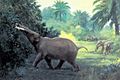
Gomphotheres (reconstructed) were hunted in Sonora by ancient Clovis hunters.
-

Cajemé, Yaqui resistance leader
-

The Cananea miners' strike 1906
-
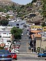
Colonia Centro, calle Pierson, Nogales
-
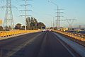
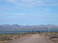
Bridge over the Colorado River in Sonora
-
Picture of the border between Arizona, on the left, and Sonora, on the right
-
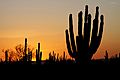
Sunset over the desert in Sonora
-
San Carlos during the wet season
-
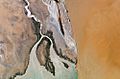
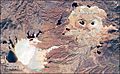
Satellite photo of the Colorado River delta in Sonora
-

Sonoran children visiting the Office of Sonora State Deputy
-
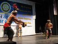
Performance of the Deer Dance
-
Punta Chueca, Sonora
-
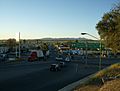
Interchange in Santa Ana near the border with trucks in view
-
Aerial view of mines in Cananea
-
Mission at Cocóspera founded by Padre Kino
-
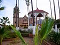
Main plaza in Álamos
-
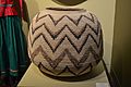
Corita basket on display at the Museo de Arte Popular, Mexico City
-
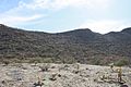
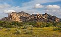
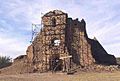
Cerro de Trincheras
-

A very large flour tortilla made in Sonora
-
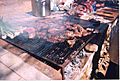
Grilling carne asada
-
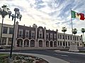
Main building at the University of Sonora, in Hermosillo
-

Entrance to the Hermosillo Airport


See also
 In Spanish: Sonora para niños
