
Border facts for kids

A border is like an invisible line that separates two areas, regions, or countries. Think of it as where one place ends and another begins. When countries share a border, people usually need special documents like a passport or a visa to cross it. A famous example is the Wagah border between Pakistan and India.
Contents
How Borders Have Changed
In the past, borders were not always clear lines. They were often wide areas called borderlands or marchlands. These areas were sometimes claimed by both sides and could be dangerous. It was harder for governments to control areas far from their main city, so outlaws sometimes hid in these borderlands.
Over time, these vague borderlands have been replaced by clear, marked lines. Today, places like airports and seaports are also considered borders because that's where people and goods enter or leave a country. Most countries check who and what crosses their borders to keep things safe and organized.
To cross a border, you might need to show legal papers like passports or visas. If you are a foreigner and want to live or work in a country, you might need special immigration documents or permits. But having these papers doesn't always mean you will be allowed to cross.
Moving goods across a border often means paying a special tax called an excise tax. Customs officials usually collect these taxes. Animals, and sometimes people, might need to go into quarantine when crossing borders. This stops the spread of diseases. Trying to move goods, animals, or people across a border secretly or without permission is called smuggling.
Some borders are not marked at all, especially in wild or forested areas. These are called "porous" borders. In some parts of Africa, people used to move freely across these porous borders to find work, food, or visit family. When colonial powers drew new, stricter borders, it changed how people moved, but many still kept their connections across these lines.
Borders can be created in different ways:
- Two countries might agree on where the border should be.
- One country might force a border on another.
- Other countries or groups might decide on a border, like at a big meeting.
- A border might be left over from an old country, a colonial power, or a noble's land.
- It could be an old border from inside a country, like in the former Soviet Union.
- Sometimes, a border was never officially drawn.
A border can also be a temporary military line, like a ceasefire line after a conflict.
Types of Borders
Political Borders
Political borders are lines that humans create. Even if a border follows a river or a mountain, it's still a political border because people decided it would be there. These borders are often sorted by whether they follow natural features or not.
Natural Borders

Natural borders are geographical features that make it hard to travel or communicate. Many old political borders were made along these natural obstacles.
Here are some natural features that often form borders:
- Oceans: Oceans are very strong natural borders because it's expensive and difficult to cross them. Only a few very large countries are spread across more than one continent.
- Rivers: Many political borders follow rivers. Examples include the Niagara River (between Canada and the U.S.), the Rio Grande (between Mexico and the U.S.), and the Rhine (between France and Germany). If a very exact line is needed, it's often drawn along the deepest part of the river, called the thalweg.
- Lakes: Large lakes can also form natural borders. For example, Lake Tanganyika separates the Democratic Republic of the Congo and Zambia from Tanzania and Burundi. The Great Lakes form a big part of the border between Canada and the United States.
- Forests: Thick jungles or forests can create strong natural borders. The Amazon rainforest is an example, separating Brazil and Bolivia from countries like Peru and Colombia.
- Mountain Ranges: Many countries have borders along mountain ranges, often following the highest ridges. The Pyrenees mountains have separated Spain and France for thousands of years. The Andes separate Chile and Argentina, and the Alps separate Italy, France, Switzerland, and Germany.
Over time, new technologies have made it easier to cross natural borders. This means natural borders are less important now than they used to be. Newer political borders, like those in Africa or the Americas, often don't follow natural features as closely as older borders in Europe or Asia do.
Landscape Borders
A landscape border is a mix of political and natural borders. It's a border that humans have designed using natural features. For example, China's Song Dynasty created a defensive forest in the eleventh century. These borders are political because they are agreed upon by countries, usually in a treaty. But they are not marked by fences. Instead, they use features like forests or water bodies that have been changed by people. Building such a border needs a lot of human effort and money.
Geometric Borders
Geometric borders are straight lines, like lines of latitude or longitude, or sometimes curves. They are drawn without considering the physical land or the people living there. You often find these kinds of political borders in areas that used to be colonies, like in North America, Africa, and the Middle East. For example, part of the Canada–United States border follows the 49th parallel, a straight line, for about 2,175 miles (3,500 km).
Fiat Borders
The idea of "fiat" boundaries is a broader way to think about geometric borders. A fiat boundary is any border that doesn't follow a natural break in the land. The word "fiat" comes from Latin and means "let it be done," showing that it's a human decision. These boundaries are often used to mark things like voting districts or postal zones.
Relic Borders

A relic border is a former boundary that is no longer a legal border. However, you can still see signs of it in the landscape. For example, the old border between East Germany and West Germany is no longer an international border, but you can still see historical markers. It also still affects the culture and economy in Germany. Another example is the Vietnamese Demilitarized Zone between North Vietnam and South Vietnam, which stopped being a border in 1975.
Lines of Control
A Line of Control (LoC) is a military border between two or more countries that is not yet a permanent, official border. LoCs are usually controlled by the military and are not recognized as official international borders. They are often the result of wars, military standoffs, or disagreements over land ownership. The first LoC was created between India and Pakistan after the Simla Agreement.
Maritime Borders
Maritime borders are lines drawn in the ocean that show where a country has special rights over the minerals and living things in that area. These borders define the areas of ocean that belong to a maritime nation. They are recognized by the United Nations Convention on the Law of the Sea.
Maritime borders are used for territorial waters, contiguous zones (areas where a country can enforce its laws), and exclusive economic zones (areas where a country has special rights to explore and use marine resources). However, this term doesn't include lake or river boundaries, which are considered part of land borders.
Some maritime borders are still not clearly defined, often because of regional problems.
Airspace Borders
Airspace is the air above a country's land and sea borders. All sovereign countries have the right to control and protect their airspace under international law. The horizontal lines of airspace are similar to the rules for "high seas" in ocean law. A country's airspace usually extends 12 nautical miles from its coast.
The vertical height of airspace is not officially set by international rules. However, it is generally agreed that airspace ends at the Kármán line. This line is about 62 miles (100 km) above Earth's surface. It marks the boundary between the atmosphere (airspace) and outer space, which has its own set of laws called space law.
Frontier
A frontier is a type of border that is open-ended on one side, meaning it's an expanding borderland. This kind of border can be a bit abstract. It has been seen as a way of thinking about human activity, especially when exploring and claiming new land, sometimes calling it terra nullius (land belonging to no one).
Images for kids
The following pictures show in how many different ways international and regional borders can be closed off, monitored, at least marked as such, or simply unremarkable.
- Borders of the World
-
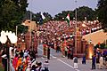
The Wagah border crossing between India and Pakistan along the Radcliffe Line.
-
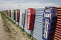
Border at Tijuana, Mexico and San Ysidro, California, United States with memorial coffins for those killed crossing this border. A straight-line border surveyed when the region was thinly populated.
-
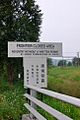
A sign showing the limits of the Frontier Closed Area, a 28-km2 area along the Hong Kong-side of the 30-km-long border between Hong Kong and mainland China.
-
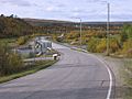
The bridge over the Anarjohka in Karigasniemi, on the border of Finland with Norway
-
The border between Argentina (Puerto Iguazú) and Brazil (Foz do Iguazú) on the Iguazú River. Paraguay (Ciudad del Este) is in the background.
-
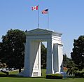
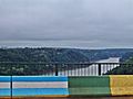
The Peace Arch at the Canada–United States border, the longest common border in the world.
-
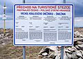
A sign at the Polish-Czech border near Králický Sněžník, indicating that only citizens of the European Union and of five more states may cross. When the Schengen rules became applicable in 2007, the sign became obsolete.
-
Self-illuminating Border flower pot between Burghausen, Salzach in Germany and Ach in Austria.
-
A border within a closely built-up area – near Aachen between Germany and the Netherlands: Germany starts at the red line drawn in the photo.
-
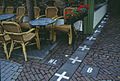
Border between the Netherlands and Belgium next to a street café in Baarle Nassau and Baarle Hertog. Some European borders originate from former land ownership boundaries.
-
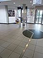
The metal strip within the building of the Eurode Business Centre marks the border between the Netherlands and Germany, in Kerkrade and Herzogenrath.
-
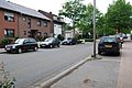
The border between the Netherlands (right) and Germany (left) is located in the center of this residential road, and, nowadays, completely unmarked.
-
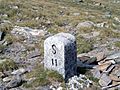
Italy/Switzerland border stone at Passo San Giacomo. Some borders were broadly defined by treaty, and surveyors would then choose a suitable line on the ground.
-
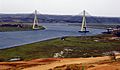
Guadiana International Bridge at the Portugal-Spain border, whose limits were established by the Treaty of Alcañices in 1297. It is one of the oldest borders in the world.
-
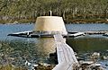
The Treriksröset cairn located at the point where Sweden, Norway and Finland meet.
-
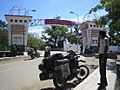
The gate that borders East Nusa Tenggara in Indonesia and East Timor.
-
The marker between the United States and Canada in Waterton-Glacier National Park.
-
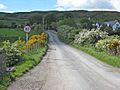
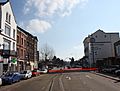
A road crossing the Republic of Ireland-United Kingdom border from the British side. This border is entirely open: the only indication that one is crossing into the Republic of Ireland is a speed limit sign in kilometers per hour (signs in the United Kingdom are in miles per hour).
-
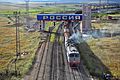
A train crossing the China–Russia border, travelling from Zabaykalsk in Russia to Manzhouli in China.
-
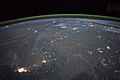
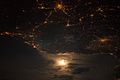
The winding border between Pakistan and India is lit by security lights. It is one of the few places on Earth where an international boundary can be seen at night.
-
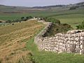
A section of Hadrian's Wall marking the border of Roman Britain


Images for kids
-
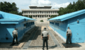
South Korean policemen standing guard at the North Korea-South Korea border. View from South Korea.
-
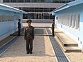
North Korean policemen standing guard at the North Korea-South Korea border. View from North Korea.
-
A photograph of the France–Italy border at night. The southwestern end of the Alps separates the two countries.
-
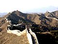
The purpose of the Great Wall of China was to stop people and militaries from crossing the northern border of China. Today it is a relic border.
-
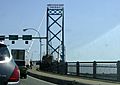
Crossing the bridge into Canada, from the US. This is the Ambassador Bridge
-
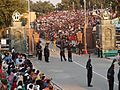
Indian and Pakistan border officers at the Indian-Pakistan border
-
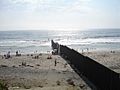
A border wall on a beach separating the United States and Mexico
-
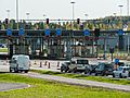
The car traffic on the Finnish side of the Russian border at the Nuijamaa Border Crossing Point in Nuijamaa, Lappeenranta, Finland


.jpg)
See also
 In Spanish: Frontera para niños
