
Niagara River facts for kids
Quick facts for kids Niagara River |
|
|---|---|

September 2001 satellite image of the Niagara River. Flowing from Lake Erie in the south (bottom of image) to Lake Ontario in the north, the river passes around Grand Island before going over Niagara Falls, after which it narrows in the Niagara Gorge. Two hydropower reservoirs are visible just before the river widens after exiting the gorge. The Welland Canal is visible on the far left side of this image. (Source: NASA Visible Earth)
|
|


|
|
| Other name(s) | rivière Niagara |
| Countries | |
| Province / State | |
| Physical characteristics | |
| Main source | Lake Erie 173.43 m (569 ft) |
| River mouth | Lake Ontario 74.1 m (243 ft) 43°04′41″N 79°04′37″W / 43.078°N 79.077°W |
| Length | 58 km (36 mi) |
| Basin features | |
| Progression | Lake Ontario→ Saint Lawrence River→ Gulf of Saint Lawrence |
| Basin size | 684,000 km2 (264,000 sq mi) |
| Tributaries |
|
| Official name: Niagara River Corridor | |
| Designated: | 3 October 2019 |
| Reference #: | 2402 |
The Niagara River (pronounced ny-AG-ər-ə) is a cool river that flows north from Lake Erie to Lake Ontario. It forms part of the border between Canada (on the west side, in Ontario) and the United States (on the east side, in New York State).
People have different ideas about where the river's name came from. Some think Niagara comes from the Niagagarega people, a Native American group who lived there. Others believe it comes from an Iroquois town called Ongniaahra, which means "point of land cut in two."
This river is about 58 kilometers (36 miles) long. It's famous for Niagara Falls, a huge waterfall along its path! Over the last 12,000 years, the falls have slowly moved about 11 kilometers (7 miles) upstream. This created the deep Niagara Gorge below the falls. Today, less erosion happens because much of the river's water is used to make electricity. The river drops a total of 99 meters (325 feet) in height from start to finish. The Niagara Gorge also has the Niagara Whirlpool and other fast-moving parts of the river.
The Niagara River is super important for making electricity! There are big power plants on both sides. On the Canadian side, you'll find the Sir Adam Beck Hydroelectric Generating Stations (built in 1922 and 1954). On the American side, there's the Robert Moses Niagara Power Plant (built in 1961). Together, these plants create a massive 4.4 gigawatts of electricity. The International Control Dam, built in 1954, helps control how much water flows down the river.
Large ships on the Great Lakes use the Welland Canal to get around Niagara Falls. This canal is part of the Saint Lawrence Seaway and is on the Canadian side of the river.
The Niagara River also has two big islands and many smaller ones. Grand Island is on the American side, and Navy Island is on the Canadian side. Goat Island and tiny Luna Island actually split Niagara Falls into its three famous sections: the Horseshoe Falls, Bridal Veil Falls, and American Falls. Another island, Unity Island, is located near the city of Buffalo.
The Niagara River and its smaller rivers, like Tonawanda Creek and the Welland River, were once part of the Erie Canal and Welland Canal systems. These canals helped boats travel safely past the falls and connect to Lake Erie.

Contents
River History
.jpg)
People outside North America learned about the Niagara River and Falls in the late 1600s. This was after Father Louis Hennepin, a French explorer, saw them for the first time. He wrote about his adventures in a book called A New Discovery of a Vast Country in America (1698).
The Niagara River was also home to America's first recorded railway! It was a wooden track built in 1764 by John Montresor, a British engineer. This railway, called "The Cradles," used ropes to pull loaded carts up wooden rails. It helped move goods over the Niagara Escarpment in what is now Lewiston, New York.
Many battles happened along the Niagara River. It was protected by forts like Fort George (Canadian side) and Fort Niagara (American side) at the river's mouth. Fort Erie (Canadian side) was at the start of the river. These forts were important during the French and Indian War and the American Revolutionary War. A big battle, the Battle of Queenston Heights, also took place near the river during the War of 1812.
Before the American Civil War, the river was a very important path to freedom. Many African-Americans escaping slavery used the Underground Railroad to cross the river and find freedom in Canada. The Freedom Crossing Monument in Lewiston remembers the brave people who escaped and the local helpers.
In the 1880s, the Niagara River became the first waterway in North America to be used for making a lot of hydroelectricity.
Today, the Niagara Parks Commission in Canada takes care of the shoreline property, including Fort Erie. They keep it as a public green space. On the American side, the New York State Office of Parks, Recreation and Historic Preservation manages several state parks near Niagara Falls and the river.
Cities and Towns


Many cities and towns are located along the Niagara River:
- Buffalo, USA
- Chippawa, Canada
- Fort Erie, Canada
- Lewiston, USA
- Grand Island, USA
- Niagara Falls, USA
- Niagara Falls, Canada
- Niagara-on-the-Lake, Canada
- North Tonawanda, USA
- Porter, USA
- Queenston, Canada
- Tonawanda (City), USA
- Tonawanda (Town), USA
- Wheatfield, USA
- Youngstown, USA
Pollution Concerns
The Niagara River is listed as a "Great Lakes Area of Concern." This means it's an area that needs special attention for its water quality, as agreed upon by the United States and Canada.
River Crossings
Many bridges cross the Niagara River, both above and below Niagara Falls. Some of these bridges have faced tough conditions like landslides and ice.
Parks Along the River

Several parks are located along the Niagara River, offering beautiful views and outdoor activities:
- Beaver Island State Park, USA
- Bowen Road Park, Canada
- Broderick Park, USA
- Browns Point Park, Canada
- Buckhorn Island State Park, USA
- De Veaux Woods State Park, USA
- Dufferin Islands Natural Area, Canada
- Earl W. Brydges Artpark State Park, USA
- Falkner Park, USA
- Fisherman's Park, USA
- Floral Clock Park, Canada
- Fort George National Historic Site, Canada
- Fort Niagara State Park, USA
- Gratwick Riverside Park, USA
- Griffon Park, USA
- Jayne Park, USA
- Joseph Davis State Park, USA
- King's Bridge Park, Canada
- MacFarland Park, Canada
- Niagara Falls State Park, USA
- Niagara Glen Nature Reserve, Canada
- Niagara Parks Botanical Gardens, Canada
- Niawanda Park, USA
- Nike Base Park, USA
- Queen's Parade Park & Memorial Park, Canada
- Queenston Heights, Canada
- Riverside Park, USA
- Strawberry Island State Park, USA
- Sugar Bowl Park, Canada
- Veterans Memorial Park, USA
- Queen Victoria Park, Canada
- Whirlpool State Park, USA
There's also a plan called the Niagara River Greenway Plan in the United States, which aims to create more green spaces along the river.
Islands of the Niagara River
Many islands are found in the upper part of the Niagara River, upstream from the falls:
- Bird Island (USA) - Now filled in.
- Brig Island (USA) - Part of Niagara Falls State Park.
- Brother Island (USA) - Near Niagara Falls, part of Niagara Falls State Park.
- Buckhorn Island (USA) - A state park at the north end of Grand Island.
- Cayuga Island (USA) - A residential area.
- Cedar Island (Canada) - Now filled in.
- Conners Island (USA) - Now filled in.
- Deer Island (USA)
- Dufferin Islands (Canada) - Man-made islands that are now parkland.
- Frog Island (USA) - Was submerged, now being rebuilt for wildlife.
- Goat Island (USA) - At the edge of the American Falls, part of Niagara Falls State Park.
- Goose Island (USA) - Was man-made, now filled in.
- Grand Island (USA) - The largest island on the river, mostly homes and businesses.
- Grass Island (USA) - Now filled in.
- Green Island (USA) - Part of Niagara Falls State Park.
- Gull Island (Canada) - Near the Old Scow shipwreck.
- Hogg Island (Canada) - Now filled in.
- Little Beaver Island (USA) - Part of Beaver Island State Park.
- Luna Island (USA) - Next to Goat Island, part of Niagara Falls State Park.
- Motor Island (USA) - A wildlife area.
- Navy Island (Canada) - A National Historic Park.
- Rattlesnake Island (USA) - Now filled in.
- Robinson Island (USA) - Part of Niagara Falls State Park.
- Ship Island (USA) - Part of Niagara Falls State Park.
- Stony Island (USA) - No longer exists.
- Strawberry Island (USA) - A small island and wildlife preserve.
- Three Sisters Islands (USA) - Next to Goat Island, part of Niagara Falls State Park.
- Tonawanda Island (USA) - Has a marina and businesses.
- Tower Island (USA) - A man-made island.
- Unity Island (USA) - Has parks and a water treatment plant.
- Willow Island (USA) - Was man-made, now filled in.
Military History
The United States Coast Guard Fort Niagara Station was once a US Army base. There are no Canadian Coast Guard posts along the river. Fort Mississauga, Fort George, and Fort Erie are old British and Canadian military forts. They are no longer used for military purposes and are now parks.
The Navy Island Royal Naval Shipyard was used by the French in the 1700s as a naval base. The Royal Navy also used it as a small shipyard from 1763 until about 1818.
Roads Along the River
On the Canadian side, the Niagara Parkway follows the river from Lake Ontario to Lake Erie.
On the American side, roads like NY 18F, Niagara Scenic Parkway, Niagara Thruway, NY 384, and NY 266 run along different parts of the river.
Images for kids
-
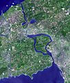
Satellite image of Niagara River flowing north from Lake Erie (bottom) to Lake Ontario (top). The river flows around Grand Island, and then flows over Niagara Falls. It narrows in the Niagara Gorge, where two hydropower reservoirs are visible, and then widens after exiting the gorge. The Welland Canal is visible on the far left.
-
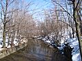
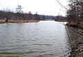
A view of Scajaquada Creek, a tributary of the Niagara River.
-
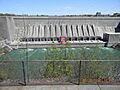
A dam on Tonawanda Creek, which flows into the Niagara River.
-
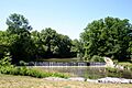
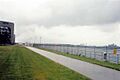
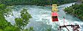
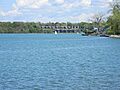
A wider view of the Niagara River.
-
Woods Creek on Grand Island, New York.
-
An image related to the Niagara Tunnel Project.
-
A view upriver from Niagara Falls.
-
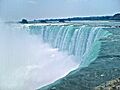
The powerful Horseshoe Falls.
-
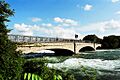
A pedestrian bridge connecting Green Island and Goat Island.
-
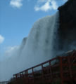
A view of Bridal Veil Falls from below.
-
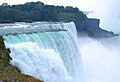
The American Falls, one of the three sections of Niagara Falls.
-
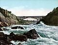
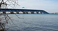
The Whirlpool Rapids Bridge crossing the Niagara River.
-
The Spanish Aero Car over the Niagara Whirlpool.
-
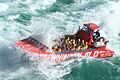
Jet boats in the Devil's Hole Rapids.
-
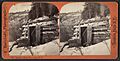
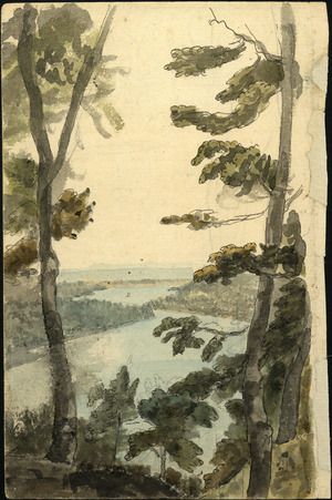
A historic view of Bloody Run, Niagara, N.Y.
-
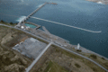
The Robert Moses Niagara Power Plant.
-
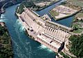
The Sir Adam Beck Hydroelectric Power Stations.
-
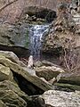
Smeaton Falls, a waterfall along the Niagara Gorge.
-
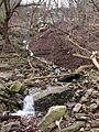
Locust Grove Falls.
-
The mouth of the Niagara River where it meets Lake Ontario.


See also
 In Spanish: Río Niágara para niños
