
Niagara Falls facts for kids
Quick facts for kids Niagara Falls |
|
|---|---|

Niagara Falls seen from the Canadian side of the river, including three individual falls (from left to right): American Falls, Bridal Veil Falls, and Horseshoe Falls.
|
|
| Lua error in Module:Location_map at line 420: attempt to index field 'wikibase' (a nil value). | |
| Location | Niagara River into the Niagara Gorge on the border of New York in the United States and Ontario in Canada |
| Coordinates | 43°04′48″N 79°04′29″W / 43.0799°N 79.0747°W |
| Type | Cataract |
| Total height | 167 ft (51 m) |
| Number of drops | 3 |
| Watercourse | Niagara River |
| Average flow rate |
85,000 cu ft/s (2,400 m3/s) |
Niagara Falls is a group of three amazing waterfalls. They are located at the southern end of the Niagara Gorge. These falls sit right on the border between Ontario, Canada, and New York, United States.
The biggest of the three falls is called Horseshoe Falls. It's also known as the Canadian Falls because it stretches across the border. The two smaller falls, American Falls and Bridal Veil Falls, are entirely within the United States. Bridal Veil Falls is separated from Horseshoe Falls by Goat Island. It's also separated from American Falls by Luna Island. Both of these islands are in New York.
The Niagara River creates these falls. This river flows from Lake Erie into Lake Ontario. Together, the Niagara Falls have the highest water flow of any waterfall in North America. This is true for falls that drop more than 50 m (164 ft). During busy daytime hours, over 168,000 m3 (5.9 million cu ft) of water rushes over the falls every minute! Horseshoe Falls is the most powerful waterfall in North America because of its huge water flow.
Niagara Falls is famous for its incredible beauty. It's also a very important source of hydroelectric power. People have worked hard since the 1800s to balance tourism, business, and power generation.
The falls are about 27 km (17 mi) northwest of Buffalo, New York. They are also 69 km (43 mi) southeast of Toronto. They sit between the cities of Niagara Falls, Ontario, and Niagara Falls, New York. Niagara Falls formed when huge glaciers melted about 10,000 years ago. Water from the newly formed Great Lakes then carved a path through the Niagara Escarpment on its way to the Atlantic Ocean.
Contents
- What Makes the Falls Special?
- How Niagara Falls Was Formed
- Protecting Niagara's Beauty
- Where Did the Name "Niagara" Come From?
- A Look Back at Niagara's History
- Bridges Over the Niagara River
- Power from the Falls
- Daring Feats at the Falls
- Visiting Niagara Falls
- Niagara Falls in Books and Movies
- Niagara Falls in Art
- Panoramic Views
- Facts About the Falls
- See also
What Makes the Falls Special?

The Horseshoe Falls is taller and wider than the others. It is about 57 m (187 ft) high. The American Falls is between 21 and 30 m (69 and 98 ft) high. This height difference is because of large rocks at its base. Horseshoe Falls is about 790 m (2,592 ft) wide. The American Falls is 320 m (1,050 ft) wide. The total distance across all the falls is 1,039 m (3,409 ft).
The most water ever recorded flowing over Horseshoe Falls was 6,370 m3/s (225,000 cu ft/s). On average, about 2,400 m3/s (85,000 cu ft/s) flows each year. The amount of water changes with the level of Lake Erie. It usually flows fastest in late spring or early summer. During summer days, at least 2,800 m3/s (99,000 cu ft/s) of water goes over the falls. About 90% of this water flows over Horseshoe Falls. The rest is sent to power plants and then over American Falls and Bridal Veil Falls. This is done using a special dam called the International Control Dam. It has gates that can be moved upstream from Horseshoe Falls.

At night and during winter, when fewer tourists visit, the water flow is cut in half. It drops to a minimum of 1,400 cubic metres per second (49,000 cu ft/s). The amount of water diverted is controlled by a treaty from 1950. The International Niagara Board of Control manages this. The water in Niagara Falls looks green. This is because about 60 tonnes of dissolved salts and very fine rock dust flow over the falls every minute. This "rock flour" is created by the river's powerful force.
The Niagara River is an important place for birds. Many Bonaparte's gulls, ring-billed gulls, and herring gulls live here. Around 100,000 seagulls spend the winter in this area. It's common to see 20,000 to 30,000 birds daily from November to January. The river and falls are attractive to birds because they are on migration routes. Birds can find food easily, and the river is less likely to freeze than other waters.
How Niagara Falls Was Formed
The features of Niagara Falls were created by the Wisconsin glaciation. This was a huge ice age about 10,000 years ago. When the ice melted, it left a lot of water. This water filled the basins carved by the glaciers, forming the Great Lakes. Scientists believe there's an old valley, St David's Buried Gorge, hidden under glacial dirt. It's near where the Welland Canal is today.

After the ice melted, the upper Great Lakes flowed into the Niagara River. The river followed the new landscape across the Niagara Escarpment. Over time, the river cut a deep gorge through the cliff. The rock layers didn't wear away evenly. The top layer is made of hard limestone and dolomite. This hard rock, called the Lockport Formation, wears away slowly. Below it is a softer layer of shale and thin limestone, called the Rochester Formation. This softer layer also contains old fossils.
The river eroded the soft layer first. This undercut the hard top layer, causing large chunks of rock to break off. This process happened many times, slowly carving out the falls. Hidden deep in the valley is another layer, the Queenston Formation. It's made of shales and fine sandstones. All these rock layers formed in an ancient sea. Their different characteristics come from changing conditions in that sea.
About 10,900 years ago, Niagara Falls was between Queenston, Ontario, and Lewiston, New York. But the falls have moved about 10.9 kilometres (6.8 mi) southward due to erosion. The Horseshoe Falls has changed shape over time. It went from a small arch to a horseshoe bend, and now it's a V-shape. Just upstream from the falls, Goat Island splits the Niagara River. This separates Horseshoe Falls from the American and Bridal Veil Falls. Engineers have worked to slow down this erosion.
What Will Happen to the Falls?
The falls are currently eroding about 30 centimeters (12 inches) each year. This is much slower than the historical average of 0.9 m (3.0 ft) per year. At this rate, in about 50,000 years, Niagara Falls will have eroded all the way back to Lake Erie. At that point, the falls will no longer exist.
Protecting Niagara's Beauty
In the 1870s, it was hard for people to see Niagara Falls. They often had to pay to get a glimpse. Factories and businesses also threatened to take over Goat Island. This led to a movement in the U.S. called Free Niagara. Important people like artist Frederic Edwin Church and landscape designer Frederick Law Olmsted led this effort. Church suggested to the Canadian governor that they create a public park together.
_(14784784605).jpg)
Goat Island was a big inspiration for the American side of the movement. In 1879, New York state asked Olmsted to study the falls. He wrote an important report about preserving Niagara Falls. The report said the state should buy the land around the falls. It called restoring the falls' beauty a "sacred obligation." In 1883, New York Governor Grover Cleveland started a law to buy land for a state park. A group of citizens also campaigned for the park.
Their efforts paid off on April 30, 1885. Governor David B. Hill signed a law creating the Niagara Reservation. This was New York's first state park. Canada also created the Queen Victoria Niagara Falls Park that same year. On the Canadian side, the Niagara Parks Commission manages all the land along the Niagara River.
In 1887, Olmsted and Calvert Vaux made plans to restore the falls. They wanted to "restore and conserve the natural surroundings," not add anything new. They planned a park with scenic roads, paths, and shelters. These designs aimed to protect the landscape while letting many visitors enjoy the falls. Later, statues, shops, restaurants, and an observation tower were added. Today, people still work to balance Olmsted's vision with the needs of a popular tourist spot.
Preservation efforts continued into the 1900s. In 1906, groups like the Sierra Club convinced the United States Congress to pass a law. This law aimed to protect the falls by controlling the Niagara River's water. A treaty in 1909 limited how much water both countries could take from the falls. This limit stayed in place until 1950.

Controlling erosion has always been important. Underwater walls redirect strong currents. The top of the falls has also been strengthened. In June 1969, a temporary dam was built. This completely stopped the Niagara River from flowing over American Falls for several months. During this time, engineers studied the riverbed. They bolted and strengthened any weak spots. This would prevent the American Falls from eroding too quickly. A plan to remove a large pile of rocks at the base was too expensive. In November 1969, the temporary dam was blown up, and water flowed over American Falls again.
Businesses have continued to build around the state park. Many tall hotels have been built on the Canadian side. This has changed the natural landscape quite a bit. One study suggested these tall buildings changed wind patterns. This might have increased the number of misty days from 29 to 68 per year.
In 2013, New York State started to fix up Three Sisters Islands. These islands are south of Goat Island. Money from a power plant helped rebuild walking paths and plant native plants. The state also improved the area around Prospect Point, which is at the edge of American Falls.
Where Did the Name "Niagara" Come From?
There are different ideas about where the name "Niagara" came from. The Native American word Ongiara means thundering water. Some say Niagara comes from the name of a local Native American group, the Niagagarega people. Another idea is that it comes from an Iroquoian town called Onguiaahra, meaning "point of land cut in two." In 1847, an Iroquois interpreter said the name came from Jaonniaka-re, meaning "noisy point or portage." To Mohawks, the name refers to "the neck," meaning the land between Lake Erie and Lake Ontario. The modern Seneca name is Jo’sgöhsodö’, which means "the cliffs are standing."
A Look Back at Niagara's History
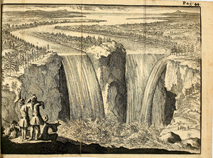
Many people have been suggested as the first European to describe Niagara Falls. The Frenchman Samuel de Champlain visited the area in 1604. His group told him about the amazing waterfalls. The first detailed description is often given to Belgian missionary Father Louis Hennepin in 1677. He traveled with explorer René-Robert Cavelier, Sieur de La Salle. This brought the falls to the attention of Europeans. Other missionaries might have visited earlier. The Finland-Swedish scientist Pehr Kalm explored the area in the early 1700s. He wrote the first scientific description of the falls. In 1762, a British Army officer and artist, Captain Thomas Davies, painted the first eyewitness picture of the falls.

In the 1800s, tourism became very popular. By the middle of the century, it was the main industry in the area. Theodosia Burr Alston and her husband were the first recorded couple to honeymoon there in 1801. Even Napoleon Bonaparte's brother, Jérôme, visited with his bride. In 1825, British explorer John Franklin called them "the first in the world for grandeur."
Frederick Douglass visited Niagara Falls in 1843. He wrote that its power was so great, he couldn't describe it. Because it was on the Canadian border, Niagara Falls was a route for the Underground Railroad. This was a network that helped enslaved people escape to freedom. The falls were also a popular spot for slave owners to visit with their enslaved workers. Sometimes, these workers would use the trip as a chance to escape. This history is remembered at the Niagara Falls Underground Railroad Heritage Center. After the American Civil War, the New York Central Railroad promoted Niagara Falls as a great place for honeymoons.
Around 1840, English chemist Hugh Lee Pattinson took the earliest known photograph of the falls. It was a daguerreotype. The picture shows a small figure with a top hat. This figure is believed to be Pattinson himself. The image was taken from the Canadian side.


On August 6, 1918, an iron scow (a type of boat) got stuck on rocks above the falls. The two men on board were rescued. But the boat is still there today, though it has moved a bit due to storms. Daredevil William "Red" Hill Sr. was praised for his help in the rescue.
After World War I, more people visited the falls because cars made travel easier. The 1900s story of Niagara Falls is about using its energy for hydroelectric power. It's also about controlling development to protect its natural beauty. Before the late 1900s, part of Horseshoe Falls was in the United States. In 1955, land was filled in to create Terrapin Point. In the early 1980s, more land was filled, and dams were built. This pushed water away from Terrapin Point. About 120 m (400 ft) of Horseshoe Falls was removed. Today, most sources say Horseshoe Falls is almost entirely in Canada.
The river and falls completely froze only once, on March 29, 1848. No water flowed for almost 40 hours. Power plants stopped working. In 1912, American Falls froze completely, but the other two kept flowing. The falls often get icy in winter, but they don't usually freeze solid. In some years, a thick "ice bridge" formed at the base of the falls. People used to cross the river on it before bridges were built. This ice could be 12 to 30 metres (40 to 100 ft) thick. In 1912, an ice bridge broke up while people were on it. Three people died in what was called the Ice Bridge Tragedy.
Bridges Over the Niagara River


Many bridges have been built across the Niagara River near the falls. The first was a suspension bridge above the gorge. It opened in 1848. A second, two-level bridge, the Niagara Falls Suspension Bridge, opened in 1855. It had a level for trains and one for other traffic. This bridge was used by conductors on the Underground Railroad to help runaway slaves reach Canada. This bridge was replaced by a new arch bridge in 1897, which is now called the Whirlpool Rapids Bridge. It is still used today. These bridges were some distance from the falls.
Closer to the falls, the first bridge opened in 1869. It was destroyed in a storm in 1889. A replacement was built quickly. To handle more traffic, a second bridge, the Upper Steel Arch Bridge, opened in 1897. It was often called the Honeymoon Bridge. This bridge was very close to the river's surface. In 1938, an ice jam twisted its steel frame, and it collapsed.
Another bridge, the Niagara Cantilever Bridge, was built in 1883 for railways. It was a strong cantilever bridge. As train traffic grew, a new bridge, the Michigan Central Railway Bridge, opened in 1925. The Cantilever Bridge was then removed.
The replacement for the Honeymoon Bridge was a steel bridge. It started being built in 1940. This bridge, named the Rainbow Bridge, opened in 1941. It has two lanes for traffic and is still used today. It offers the closest views of the falls.

Power from the Falls
How Hydroelectric Power Works

People have long known that Niagara Falls could be a great source of power. The first known attempt to use the water was in 1750. A man named Daniel Joncaire built a small canal to power his sawmill. Later, in 1805, Augustus and Peter Porter bought this area. They made the canal bigger to power their mills. In 1853, a company was formed to build canals for electricity. In 1881, the first hydroelectric power station was built. It used water falling 26 metres (86 ft) to create electricity. This power ran local mills and lit up some streets.
In 1890, a group of scientists looked at ideas to expand Niagara's power. In 1893, Westinghouse Electric was hired to design a system for alternating current (AC) power. A large AC power system was created in 1895. The Adams Power Plant Transformer House is a landmark from this original system.

By 1896, rich investors helped build huge underground tunnels. These tunnels led to turbines that generated over 75 megawatts (100,000 hp) of power. This power was sent as far as Buffalo, 32 km (20 mi) away. Canadian companies also started using the falls' energy. The Government of Ontario took control of power distribution in 1906. This helped send Niagara's energy across the province.
More power plants were built along the Niagara River. But in 1956, a big power station was partly destroyed by a landslide. This greatly reduced power and put many jobs at risk. In 1957, Congress passed a law. It allowed the New York Power Authority to fully develop the U.S. share of Niagara's hydroelectric power.
In 1961, the Niagara Falls hydroelectric project opened. It was the largest hydropower facility in the Western world. Today, Niagara is still New York state's biggest electricity producer. It can generate 2.4 gigawatts of power. Up to 1,420 cubic metres per second (50,000 cu ft/s) of water is sent from the Niagara River through tunnels. This water goes to the Lewiston and Robert Moses power plants. This happens far upstream from the waterfalls. The water then goes through turbines to create power for Canada and the U.S. It returns to the river after the falls. When less electricity is needed, the Lewiston plants can pump water back up to a reservoir. This water can then be used again when electricity use is high.

To keep Niagara Falls beautiful, the U.S. and Canada signed a treaty in 1950. It limits how much water power plants can use. More water can be diverted at night during summer and in winter when there are fewer tourists. This treaty ensures an "unbroken curtain of water" over the falls. It says that during the day in tourist season (April 1 to October 31), 2,800 cubic metres per second (100,000 cu ft/s) of water must flow over the falls. At night and in the off-season, 1,400 cubic metres per second (50,000 cu ft/s) must flow. The International Niagara Board of Control monitors this. In winter, power companies work together to prevent ice from causing problems. They use an 8,800-foot-long (2,700 m) ice boom to stop ice buildup.
In August 2005, Ontario Power Generation started a big project. They built a new 12.7-metre (42 ft) wide, 10.2-kilometre-long (6.3 mi) water diversion tunnel. It opened in March 2013. This tunnel helped increase power production by 150 megawatts. It provides new hydroelectricity for about 160,000 homes.
How People Travel Around the Falls

Ships can get around Niagara Falls using the Welland Canal. This canal was improved in the 1950s as part of the Saint Lawrence Seaway. While the seaway changed water traffic, other industries in the Niagara River valley grew. They used the electric power from the river. However, since the 1970s, the region's economy has slowed down.
The cities of Niagara Falls, Ontario (Canada) and Niagara Falls, New York (U.S.) are connected by two international bridges. The Rainbow Bridge is just downstream from the falls. It offers the closest view and is open to cars and people. The Whirlpool Rapids Bridge is 1.6 kilometres (1 mi) north of the Rainbow Bridge. It is the oldest bridge over the Niagara River. The nearby Niagara Falls International Airport and Buffalo Niagara International Airport are named after the waterfall. So are Niagara University and many local businesses.
Daring Feats at the Falls
Jumps, Plunges, and Walks

The first recorded stunt at the falls was in 1827. Hotel owners loaded an old boat with animals and fake people. They let it plunge over the falls. People paid to watch.
In 1829, Sam Patch jumped from a high tower into the gorge below the falls and survived. This started a tradition of daredevils trying to go over the falls. In 1883, Matthew Webb, the first man to swim the English Channel, drowned trying to swim the rapids below the falls.
On October 24, 1901, 63-year-old teacher Annie Edson Taylor was the first person to go over the falls in a barrel. She survived with only minor injuries. She later said, "No one ought ever do that again." Days before her attempt, her cat was sent over in the barrel to test it. The cat survived unharmed! Since then, over a dozen people have intentionally gone over the falls in a device. Some survived, but others were hurt or died. Survivors face fines because it's illegal to try this stunt.
Charles Stephens was the first person to die trying to go over the falls in a barrel in 1920. Bobby Leach went over Horseshoe Falls in a steel barrel in 1911. He needed to be rescued by William "Red" Hill Sr.. In 1928, "Smiling Jean" Lussier went over in a large rubber ball and survived.

In a "Miracle at Niagara" on July 9, 1960, seven-year-old Roger Woodward was swept over Horseshoe Falls. His sister was pulled from the river just 6 m (20 ft) from the edge. Roger was rescued from the water below the falls after grabbing a life ring from the Maid of the Mist boat. Their uncle, who was steering the boat, died.
On July 2, 1984, Canadian Karel Soucek went over Horseshoe Falls in a barrel. He had only minor injuries but was fined for the illegal stunt. In 1985, he died trying to re-create the stunt at the Astrodome.
In August 1985, Steve Trotter became the youngest person (age 22) to go over the falls in a barrel. Ten years later, he did it again with Lori Martin. They both survived.
On September 28, 1989, Peter DeBernardi and Jeffery James Petkovich were the first "team" to go over in a two-person barrel. They survived with minor injuries and were charged with an illegal stunt.

On June 5, 1990, Jesse Sharp, a kayaker, paddled over the falls in a canoe. He didn't wear a helmet or life vest. His boat was found, but his body was never recovered. On October 1, 1995, Robert Douglas "Firecracker" Overacker went over the falls on a Jet Ski. His parachute failed, and he died.
Kirk Jones became the first known person to survive a plunge over Horseshoe Falls without a flotation device on October 20, 2003. He had only minor injuries. Jones tried again in 2017 using an inflatable ball but died.
On March 11, 2009, a man survived an unprotected trip over Horseshoe Falls. He had severe hypothermia and a head wound. His identity was not released. On May 21, 2012, another unidentified man survived an unprotected trip. On July 8, 2019, a man intentionally jumped into the river and went over Horseshoe Falls. He was found alive but injured on the rocks below.
Tightrope Walkers

Tightrope walkers also attracted huge crowds. Their wires stretched across the gorge, not over the waterfalls. Jean François "Blondin" Gravelet was the first to cross Niagara Gorge on a tightrope in 1859. He did it eight more times that year. His most famous crossing was carrying his manager on his back. His last crossing was watched by the Prince of Wales.
Maria Spelterini, a 23-year-old Italian woman, was the first and only woman to cross the Niagara River gorge on a tightrope. She did it on July 8, 1876. She repeated the stunt several times, even blindfolded or with her hands and feet tied.
On June 15, 2012, high wire artist Nik Wallenda was the first person to walk across the falls area in 116 years. He got special permission from both governments. His tightrope was 550 metres (1,800 ft) long. Wallenda crossed near the edge of Horseshoe Falls, unlike earlier walkers who crossed further downstream. He carried his passport and had to show it when he arrived on the Canadian side.
Fish
According to river expert Wes Hill, about 90% of fish that go over the falls actually survive!
Visiting Niagara Falls

The busiest time to visit Niagara Falls is in the summer. The falls are beautiful both day and night. From the Canadian side, bright floodlights light up both sides of the falls for several hours after dark. In 2007, about 20 million people visited. By 2009, this number was expected to reach over 28 million tourists each year.
The oldest and most famous tourist attraction is the Maid of the Mist boat cruise. It has taken passengers into the rapids below the falls since 1846. These boats operate from both the American and Canadian sides.
From the U.S. side, you can see American Falls from walkways at Prospect Point Park. This park also has the Prospect Point Observation Tower and a boat dock for the Maid of the Mist. Goat Island offers more views of the falls. You can reach it by walking or driving over a bridge. From Goat Island, you can take an elevator to the Cave of the Winds. This path leads hikers to a spot right beneath Bridal Veil Falls. Goat Island also has the Three Sisters Islands and a statue of Nikola Tesla. Tesla was an inventor whose work helped harness the falls' power. Most of these attractions are part of the Niagara Falls State Park.

The Niagara Scenic Trolley offers guided tours around American Falls and Goat Island. You can also get amazing panoramic views from a helicopter. The Niagara Gorge Discovery Center teaches about the natural history of the falls. The Seneca Niagara Casino & Hotel is a casino and hotel in Niagara Falls, New York. It's the first new tall building in the city's skyline since the 1920s.
On the Canadian side, Queen Victoria Park has beautiful gardens. It offers platforms with views of American, Bridal Veil, and Horseshoe Falls. There are also underground walkways leading to observation rooms. These rooms make it feel like you are inside the falling water. The Niagara River Recreational Trail runs 56 km (35 mi) along the river. It includes many historical sites from the War of 1812.

The observation deck of the Skylon Tower offers the highest view of the falls. On a clear day, you can even see Toronto. The Whirlpool Aero Car is a cable car that takes passengers over the Niagara Whirlpool on the Canadian side. The Journey Behind the Falls has an observation platform and tunnels near the bottom of Horseshoe Falls. There are also two casinos on the Canadian side: the Niagara Fallsview Casino Resort and Casino Niagara.

Helicopter tours over the falls are still popular. They offer unique views, even though there have been some accidents. These flights have been available since the early 1960s.
Niagara Falls in Books and Movies
Movies and Television

Niagara Falls was already a popular tourist spot. Visits increased greatly in 1953 after the movie Niagara came out. It starred Marilyn Monroe. The 1956 cartoon Niagara Fools showed Woody Woodpecker trying to go over the falls in a barrel. The falls were also a key location in the 1980 movie Superman II. They were also the subject of a popular IMAX movie, Niagara: Miracles, Myths and Magic. Illusionist David Copperfield performed a trick where he seemed to travel over Horseshoe Falls in 1990.
The area around the falls was the setting for the TV show Wonderfalls in 2004. Footage of the falls was used in the 2006 movie Pirates of the Caribbean: At World's End. The 2015 film Chasing Niagara shows kayaker Rafa Ortiz preparing to paddle over the falls.
Kevin McMahon's 1991 documentary The Falls explored how people imagine Niagara Falls.
Literature

The Niagara Falls area is featured in the H. G. Wells novel The War in the Air. Many poets have written about the falls. Cuban poet José Maria Heredia wrote the poem "Niagara." There are plaques on both sides of the falls honoring this poem. In 1818, American poet John Neal published "Battle of Niagara." It was considered the best poem about the falls at that time. In 1835, Letitia Elizabeth Landon wrote "The Indian Girl." It tells the story of an Indian girl who guides her canoe over the falls in despair.
Lydia Sigourney wrote two poems about the falls, "Niagara," in 1836 and 1845. In 1848, Rev. C. H. A. Bulkley published a long poem called Niagara: A Poem. It described the wonders of the falls.
In 1893, Mark Twain wrote a funny story called "The First Authentic Mention of Niagara Falls." In it, Adam and Eve live at the Falls.
Music
Composer Ferde Grofé wrote the Niagara Falls Suite in 1960. He did this to celebrate the completion of the first stage of hydroelectric work at the falls. In 1997, composer Michael Daugherty wrote Niagara Falls, a piece for a concert band.
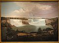
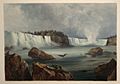
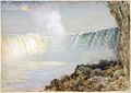
Niagara Falls in Art
Niagara Falls was so popular with landscape artists that it was "the most popular, the most often treated, and the tritest single item of subject matter to appear in eighteenth- and nineteenth-century European and American landscape painting". Author Ginger Strand notes that "Every time there was an advance in picture-making, folks raced to the Falls to try it out." This included engravings, photographs, and early movies.
-
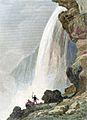
A General View of the Falls of Niagara by Alvan Fisher, 1820
-
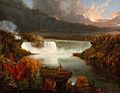
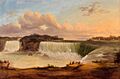
Distant View of Niagara Falls by Thomas Cole, 1830
-
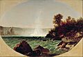
Niagara Fälle. Les chûtes du Niagara. Niagara Falls by Karl Bodmer, around 1832
-
Voute sous la Chute du Niagara – Niagara Falls, Jacques-Hippolyte van der Burch, around 1841
-
As seen from the Canadian side, by Victor de Grailly, 1845
-
Niagara Falls by John Frederick Kensett, around 1852-1854
-
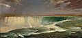
Niagara by Frederic Edwin Church, 1857
-
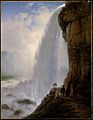
Underneath Niagara Falls by Ferdinand Richardt, 1862
-
Niagara by Louis Rémy Mignot, around 1866
-
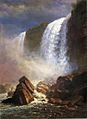
Falls of Niagara from Below by Albert Bierstadt, 1869
-
Niagara Falls by William Morris Hunt, 1878
-
Niagara Falls, Arthur Parton around 1880


.jpg)


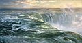
Panoramic Views
.jpg)

Facts About the Falls

The Horseshoe Falls drops about 57 meters (188 feet). The American Falls is a bit different. Its height changes between 21 and 30 meters (70 to 100 feet) because of giant rocks at its bottom. The Horseshoe Falls is about 790 meters (2,590 feet) wide. The American Falls is 320 meters (1,050 feet) wide. The total distance across all the falls from the American side to the Canadian side is about 1,039 meters (3,409 feet).
A lot of water flows over the falls! The most water ever recorded going over Horseshoe Falls was 6,400 cubic meters (226,000 cubic feet) per second. On average, about 2,400 cubic meters (85,000 cubic feet) of water flows per second each year. More water flows in late spring or early summer because of the water level in Lake Erie.
During summer, at least 2,800 cubic meters (99,000 cubic feet) of water flows over the falls every second. About 90% of this water goes over the Horseshoe Falls. The rest is sent to power plants that make electricity. This is done using a special dam with gates upstream from the Horseshoe Falls. At night, the water flow is cut in half. In winter, when fewer tourists visit, the flow stays at a minimum of 1,400 cubic meters (49,000 cubic feet) per second.
The water flowing over Niagara Falls looks green. This is because about 60 tons of dissolved salts and "rock flour" are carried by the river every minute. Rock flour is very finely ground rock that makes the water look cloudy and green.
See also
 In Spanish: Cataratas del Niágara para niños
- List of waterfalls
- List of waterfalls of Canada
- International Control Dam
- International Niagara Board of Control
- Incline railways at Niagara Falls
- Table Rock, Niagara Falls
