Grand Island, New York facts for kids
Quick facts for kids
Grand Island
La Grand Île (French)
|
|
|---|---|
| Town of Grand Island | |
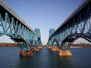
South Grand Island Bridge
|
|
| Nickname(s):
La Grande Île |
|
| Motto(s):
"A Grand Place to Live" |
|
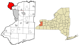
Location in Erie County and New York.
|
|
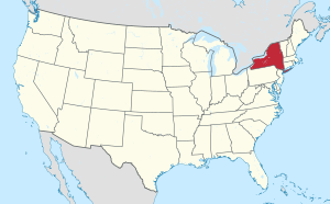
Location of New York in the United States
|
|
| Country | |
| State | |
| County | Erie |
| Incorporated | 1852 |
| Area | |
| • Total | 33.29 sq mi (86.23 km2) |
| • Land | 28.27 sq mi (73.23 km2) |
| • Water | 5.02 sq mi (13.00 km2) |
| Elevation | 591 ft (180 m) |
| Population
(2020)
|
|
| • Total | 21,389 |
| • Density | 736.68/sq mi (284.44/km2) |
| Time zone | UTC-5 (EST) |
| • Summer (DST) | UTC-4 (EDT) |
| ZIP Code |
14072
|
| Area code(s) | 716 |
| FIPS code | 36-029-29828 |
| FIPS code | 36-29828 |
| GNIS feature ID | 0979012 |
Grand Island is an island town in Erie County, New York, United States. In 2020, about 21,389 people lived there. This was a 5% increase from 2010.
The town's name comes from the French phrase La Grande Île, which means "The Big Island." Grand Island is the largest island in the Niagara River. It is also the third largest island in New York State. You can see the phrase La Grande Île on the town's official seal.
Long ago, Grand Island was home to the Neutral Nation of Native Americans. Later, both French and English explorers claimed the island. In 1945, there was a plan to make Grand Island part of a new "World Peace Capital." This capital would have been on the border between Canada and the United States. The idea was to put the United Nations headquarters on nearby Navy Island in Canada. This spot was chosen because it was between two peaceful countries. The plan showed bridges connecting Grand Island to Canada. However, the proposal was not chosen. The UN headquarters ended up in New York City instead.
Grand Island is in the northwest part of Erie County. It is also very close to the border with Canada, but there is no way to cross the river to Canada from the island. The island is northwest of Buffalo and south of Niagara Falls. Major roads like Interstate 190 and New York State Route 324 cross the island.
Contents
History of Grand Island
Early History and Native Americans
When French explorers first arrived, they found Native Americans called the Neutral Nation (also known as the Attawandaron) living on Grand Island. By 1651, the powerful Seneca Nation had taken over the island. They either chased away or absorbed the Neutral people. After that, the Seneca Nation used the island for hunting and fishing.
In 1764, after the French and Indian War, the island became part of the British colonies in North America. This was part of a peace treaty.
Grand Island After the American Revolution
In 1815, New York State bought Grand Island and other small islands in the Niagara River from the Iroquois nation. The state paid $1,000 upfront and agreed to pay $500 every June forever. Important people like Governor Daniel D. Tompkins and Chief Red Jacket signed this agreement. The Seneca people kept their right to hunt and fish on the islands.
In 1824, a journalist named Mordecai Manuel Noah had a unique idea. He wanted to create a "Jewish homeland" on Grand Island. He planned to call it Ararat, like Mount Ararat from the Bible. However, his idea didn't get much support from other Jewish people. It never became more than a special ceremony where a cornerstone was laid.
The town of Grand Island was officially formed in 1852. It was created from a part of the town of Tonawanda.
In 1993, the Seneca Nation went to court. They wanted to get back land on Grand Island that they believed was taken from them unfairly. They argued that New York State's purchase in 1815 was against an old law. This law said Native American lands could not be sold without the U.S. government's permission. The Seneca Nation wanted more than 2,000 property owners on the island to leave.
However, the courts decided that the land had already been given to Great Britain in treaties from 1764. This meant the Seneca did not own the land when the 1794 Treaty of Canandaigua was signed. The courts said New York State's purchase in 1815 was just to avoid problems with the Seneca over land the state already owned. The Seneca Nation tried to appeal this decision, but the higher courts, including the Supreme Court of the United States, agreed with the original ruling.
Geography of Grand Island
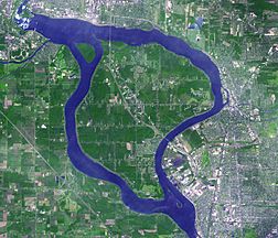
Grand Island covers about 33.29 square miles (86.2 square kilometers). About 28.27 square miles (73.2 square kilometers) is land, and 5.02 square miles (13.0 square kilometers) is water.
The Niagara River splits into two parts at the south end of the island. It then comes back together at the northwest end. This is about 3 miles (5 km) upstream from Niagara Falls.
The town is next to the border between Canada and the United States. However, there are no bridges or ferries directly connecting the island to Canada. This means there are no customs or immigration services here.
Two bridges connect the south end of Grand Island to the town of Tonawanda. Another two bridges connect the northern end to the city of Niagara Falls in Niagara County. These bridges are part of Interstate 190, which is a branch of the New York State Thruway. Also, New York State Route 324 (Grand Island Boulevard) joins I-190 at the southern bridges. It ends in the northern part of Grand Island.
Neighboring Areas
- Niagara Falls, Ontario, Canada – to the west
- Fort Erie, Ontario, Canada – to the southwest
- Town of Tonawanda, New York – to the southeast
- City of Tonawanda, New York - to the east
- City of North Tonawanda, New York – to the east
- Town of Wheatfield, New York – to the northeast
- City of Niagara Falls, New York – to the northwest
Main Roads and Highways
 Interstate 190 (Niagara Thruway): This highway crosses the island from north to southeast. It uses the North and South Grand Island Bridges.
 New York State Route 324 (Grand Island Blvd.): This road goes east-west through the middle of town. It joins I-190 as it goes towards Tonawanda.
- Beaver Island Parkway: This road goes north-south from I-190 to Beaver Island State Park.
- West River Parkway: This road used to run along the western side of the island next to the Niagara River. It was closed in 2017 and turned into a path for bikes and walking in 2018.
People and Population
| Historical population | |||
|---|---|---|---|
| Census | Pop. | %± | |
| 1860 | 954 | — | |
| 1870 | 1,126 | 18.0% | |
| 1880 | 1,156 | 2.7% | |
| 1890 | 1,048 | −9.3% | |
| 1900 | 1,036 | −1.1% | |
| 1910 | 914 | −11.8% | |
| 1920 | 728 | −20.4% | |
| 1930 | 626 | −14.0% | |
| 1940 | 1,055 | 68.5% | |
| 1950 | 3,090 | 192.9% | |
| 1960 | 9,607 | 210.9% | |
| 1970 | 13,977 | 45.5% | |
| 1980 | 16,770 | 20.0% | |
| 1990 | 17,561 | 4.7% | |
| 2000 | 18,621 | 6.0% | |
| 2010 | 20,374 | 9.4% | |
| 2020 | 21,389 | 5.0% | |
| U.S. Decennial Census | |||
In 2000, there were 18,621 people living in Grand Island. There were 6,898 households and 5,221 families. The town had about 653 people per square mile.
Most of the people in Grand Island were White (95.80%). There were also African American (3.17%), Native American (0.25%), and Asian (1.17%) residents. About 1.09% of the population was Hispanic or Latino.
About 35.8% of households had children under 18. Most households (64.8%) were married couples. The average household had 2.68 people. The average family had 3.13 people.
The population was spread out by age. About 26.7% were under 18. About 11.3% were 65 or older. The average age was 39 years old.
In 2000, the average income for a household in Grand Island was $60,432. The average income for a family was $70,521. About 3.0% of the population lived below the poverty line. This included 3.3% of those under 18 and 5.1% of those 65 or older.
Communities and Places on Grand Island
- Fairview Court – A small community on the southwest side of the island.
- Falconwood – A community on the southeast shore. It is named after the Falconwood Club.
- Ferry Village – A community near Beaver Island State Park.
- Grandyle Village – A neighborhood near Beaver Island Parkway and the South Grand Island Bridge.
- Hennepin Road – A road in Grandyle Village. It is named after French explorer Louis Hennepin. He was the first to describe Niagara Falls in 1677.
- North Grand Island Bridge – This bridge goes north to the city of Niagara Falls.
- Oakfield – A place north of Beaver Island State Park.
- Sandy Beach – A community on the northeast shore of the island.
- Sheenwater – A place on the west shore of the island.
- Edgewater – A place on the northeast shore of the island.
- Sour Springs Grove – A place by the shore in the southeast part of the town.
- South Grand Island Bridge – This bridge goes southeast to Tonawanda, which is a suburb of Buffalo.
Fun Places to Visit
- Beaver Island State Park – A large park at the south end of the island. It has many activities, including a golf course.
- Buckhorn Island State Park – A park at the north end of Grand Island. It is known for protecting the local environment.
- Grand Island Nike Base – This is now a town park and senior citizen center. It used to be a US Army missile site in the 1950s and 1960s.
- Grand Island Rod and Gun Club – A place for shooting rifles, trap and skeet, and archery. It also has a small pond for fishing.
- Niagara Amusement Park & Splash World – A large amusement park that opened in 1961.
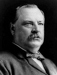
- River Lea Farmhouse – An old Victorian farmhouse built in 1873. It was once owned by Grover Cleveland's uncle. Cleveland, who later became president, had his first job working on this farm.
- Spaulding-Sidway Boathouse – This historic boathouse was added to the National Register of Historic Places in 1998.
- Veterans Park – A park in the northern part of town. Many local children's sports events are held here.
- Woods Creek – A small stream that flows into the Niagara River at Buckhorn Island Park.
Famous People from Grand Island
- Jimmy Arias, a retired tennis player.
- Carly Beth, a singer-songwriter.
- Dale Brown, a best-selling author of military thrillers. He graduated from Grand Island High School in 1974.
- Stacy Clark, a singer/songwriter. She graduated from Grand Island High School in 1998.
- Grover Cleveland, the 22nd and 24th U.S. president. He owned a home in Beaver Island.
- Charles N. DeGlopper, a World War II hero who received the Medal of Honor. He was born and grew up on Grand Island.
- Carlin Hartman, an assistant basketball coach for the Oklahoma Sooners.
- Thom Hatch, an award-winning author and historian.
- Brett Kern, an NFL player for the Tennessee Titans.
- Mohamed Abdullahi Mohamed, a former President of Somalia.
- Mordecai Manuel Noah, an American writer and diplomat. He tried to create a Jewish homeland on Grand Island.
- Larry Playfair, a retired NHL hockey player.
- Paul Schenck, an Episcopal priest.
- Rob Schenck, an evangelical minister.
- Bill Scherrer, a retired Major League Baseball player.
- Ramblin' Lou Schriver, a country musician and radio broadcaster.
- Leonard F. Walentynowicz, a former United States Assistant Secretary of State.
Schools on Grand Island
Public Schools
These schools are part of the Grand Island Central School District.
- Grand Island High School
- Veronica E. Connor Middle School
- William M. Kaegebein Elementary School
- Huth Road Elementary School
- Charlotte Sidway Elementary School
Private Schools
- St. Stephen School
See also
 In Spanish: Grand Island (Nueva York) para niños
 | Tommie Smith |
 | Simone Manuel |
 | Shani Davis |
 | Simone Biles |
 | Alice Coachman |


